
Mount Kanaga facts for kids
Quick facts for kids Mount Kanaga |
|
|---|---|

View, looking west to Kanaga Volcano in 1994 eruption.
|
|
| Highest point | |
| Elevation | 4,288 ft (1,307 m) |
| Geography | |
| Location | Kanaga Island, Alaska, U.S. |
| Parent range | Aleutian Range |
| Topo map | USGS Adak C-4 |
| Geology | |
| Mountain type | Stratovolcano |
| Volcanic arc/belt | Aleutian Arc |
| Last eruption | February 2012 |
Mount Kanaga is a tall volcano located on Kanaga Island in Alaska. This island is part of the Aleutian Islands. Mount Kanaga is known as a stratovolcano. This means it's a cone-shaped volcano built up by many layers of hardened lava, ash, and rocks.
The volcano sits inside a large bowl-shaped area called a caldera. This caldera was formed when the ground collapsed after a big eruption. There's even a crater lake inside the caldera. The very top of Mount Kanaga has a crater. This crater has fumaroles, which are vents that release steam and gases from inside the Earth.

Mount Kanaga is about 25 kilometers (16 miles) west of Adak Island. Adak Island has a U.S. Navy base and port.
Volcanic Activity
Mount Kanaga has erupted several times. One important eruption happened throughout much of 1994. During this time, the volcano released fine ash. This ash even reached the community of Adak at least once. The last known eruption of Mount Kanaga was in February 2012.
Images for kids
-
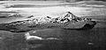
Aerial photograph of Kanaga Island produced in 1952 by the United States Navy
-
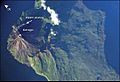
Kanaga Island with Mount Kanaga seen from space
-
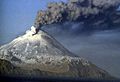
Kanaga Volcano, Kanaga Island, Aleutians
-
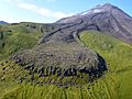
Lava flow formed by 1906 eruption of Mount Kanaga


.jpg)
See also
 In Spanish: Monte Kanaga para niños
