
Mount Maxwell facts for kids
Quick facts for kids Mount Maxwell |
|
|---|---|

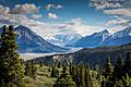
Mount Maxwell and Kaskawulsh Glacier
|
|
| Highest point | |
| Elevation | 3,020 m (9,910 ft) |
| Prominence | 509 m (1,670 ft) |
| Parent peak | Mount Leacock (3100 m) |
| Geography | |

Mount Maxwell
Location in Yukon
|
|
| Location | Yukon, Canada |
| Parent range | Saint Elias Mountains |
| Topo map | NTS 115.B.10 |
| Climbing | |
| Easiest route | Mountaineering |
Mount Maxwell is a tall mountain in Yukon, Canada. It stands at about 3,020-metre (9,910-foot) high. This impressive peak is part of the Saint Elias Mountains. You can find it inside Kluane National Park and Reserve, a beautiful protected area. The mountain is located right at the edge of the huge Kaskawulsh Glacier.
About Mount Maxwell
You can't see Mount Maxwell from any roads. But if you visit the Slims River valley, you might catch a glimpse of it. The closest taller mountain is Mount Leacock, which is about 9.2 km (5.7 mi) to the south.
The climate around Mount Maxwell is called a subarctic climate. This means it has very long, cold, and snowy winters. The summers are usually mild.
How Mount Maxwell Got Its Name
The mountain was named by John Oliver Wheeler. He was a Canadian geologist who worked for the Geological Survey of Canada. Wheeler climbed Mount Maxwell in 1954.
The name "Maxwell" was officially approved in 1960. It became fully official in 1981, thanks to the Geographical Names Board of Canada. However, it's still a mystery who Maxwell was. We don't know if it was named after a person, a place, or something else.
There's a small mix-up on some maps. The name "Mt Maxwell" is sometimes placed about five kilometers northeast of where the actual mountain summit is.
Images for kids
-
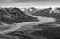
Mount Maxwell centered in the distance
-
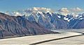
Mount Maxwell centered on horizon
-
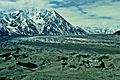
West aspect
-
Mount Maxwell with Kaskawulsh Glacier
.jpg)


