
Mount Raimer facts for kids
Quick facts for kids Mount Raimer |
|
|---|---|
| Highest point | |
| Elevation | 2,572 ft (784 m) |
| Geography | |
| Location | Williamstown, Massachusetts and Rensselaer County, New York |
| Parent range | Taconic Mountains |
| Geology | |
| Age of rock | Ordovician |
| Mountain type | Thrust fault; metamorphic rock and sedimentary rock |
| Climbing | |
| Easiest route | Taconic Crest Trail |
Mount Raimer is a tall mountain, about 2,572 feet (784 m) high, in the Taconic Mountains. It sits on the border between western Massachusetts and New York. The top of the mountain and its western side are in New York, while the eastern slopes are in Massachusetts.
The top of Mount Raimer has both open meadows and wooded areas. You can find trees like red spruce, balsam fir, and other hardwood trees there. The mountain is famous for its amazing views of the Hoosic River valley and the Hudson River Valley. A long hiking path called the 35 mi (56 km) Taconic Crest Trail goes right over the mountain. Much of the upper parts of Mount Raimer are protected land. The mountain was also once home to a ski area that is now closed.
Where is Mount Raimer Located?
Mount Raimer is found in Williamstown, Massachusetts, and in the New York towns of Petersburgh and Berlin. To the south, the Taconic Mountains continue with Berlin Mountain. To the north, they extend as the White Rock ridgeline.
On its east side, Mount Raimer is surrounded by smaller hills. These hills lead down to the Hoosic River Valley and the town of Williamstown. Water from the west side of the mountain flows into the Little Hoosic River, then into the Hoosic River, and finally into the Hudson River. Water from the east side drains directly into the Hoosic River.
A place called Petersburg Pass is located on New York Route 2/ Massachusetts Route 2. This pass cuts through the mountains between Mount Raimer and Smith Hill, which is the next peak to the north. Petersburg Pass is about 1,650 feet (500 m) high and is only about .75 miles (1.21 km) north of Mount Raimer's summit.
History of Skiing at Mount Raimer
|
||||||||||
Mount Raimer used to have a ski area with lifts for almost 20 years. It was first known as Petersburg Pass Ski Area. The main building and parking areas were right next to New York State Route 2.
The ski area opened in 1962. It had many different ski trails. A Poma double chairlift took skiers up the mountain. In 1964, a smaller surface lift was added for beginners near the bottom.
The ski area faced many challenges. It was hard for people to drive up the steep Route 2. Also, there wasn't enough water to make artificial snow. Because of these problems, the ski area often closed for several seasons in the 1970s. To try and improve its image, Petersburg Pass Ski Area changed its name twice. After a short time as Taconic Trails, it was last known as Mount Raimer.
There was an effort to make the ski area much bigger in its final years. New trails were cut on the western side of the mountain. However, this expansion was never finished, and the ski area closed down in 1980.
Recently, since about 2010, people have become interested in the area again. They use some of the old, unused trails for backcountry skiing. The double chairlift from Mount Raimer was later sold to another ski resort called Ski Butternut.
Images for kids
-
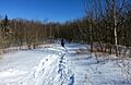
A 2014 photo of one of the backcountry ski trails near the summit of Mount Raimer

- Massachusetts Trail Guide (2004). Boston: Appalachian Mountain Club.
