Mount Schank, South Australia facts for kids
Quick facts for kids Mount SchankSouth Australia |
|||||||||||||||
|---|---|---|---|---|---|---|---|---|---|---|---|---|---|---|---|

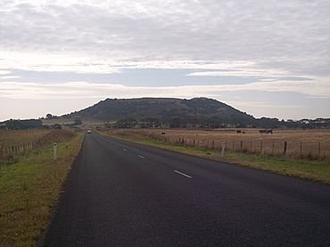
View of Mount Schank from the road to Port MacDonnell.
|
|||||||||||||||
| Established | 31 October 1996 | ||||||||||||||
| Postcode(s) | 5291 | ||||||||||||||
| Time zone | ACST (UTC+9:30) | ||||||||||||||
| • Summer (DST) | ACST (UTC+10:30) | ||||||||||||||
| Location |
|
||||||||||||||
| LGA(s) | District Council of Grant | ||||||||||||||
| State electorate(s) | Mount Gambier | ||||||||||||||
| Federal Division(s) | Barker | ||||||||||||||
|
|||||||||||||||
|
|||||||||||||||
| Footnotes | Locations Climate Adjoining localities |
||||||||||||||
Mount Schank is a place in the Australian state of South Australia. It is about 385 kilometers (239 miles) south-east of Adelaide, the state capital. It's also about 14 kilometers (9 miles) south of Mount Gambier.
Discovering Mount Schank
Mount Schank is a special area in South Australia. It is known for its interesting history and unique natural features. The area is named after the nearby Mount Schank, which is a dormant (sleeping) volcano.
Early History and Settlement
British settlement in the Mount Schank area began in 1842. Two brothers, Edward and Fortescue Arthur, started a large sheep farm called the Mount Schank Station. They were the sons of Sir George Arthur.
Setting up the sheep station was very challenging for the Arthur brothers. They faced many difficulties, including their shepherds leaving and losing sheep. The brothers worked hard to keep their farm going.
Changes in Ownership
The Arthur brothers found it too difficult to continue running the sheep station. In 1844, they sold it to Robert Leake, who owned a nearby farm called Glencoe station.
After Robert Leake, the Clarke family owned Mount Schank station for about 140 years. Then, in 2005, Ron Evans bought the property. He was once the chairman of the AFL. By 2017, the property was worth around fifty million dollars.
How Mount Schank Was Formed
The boundaries for the area called Mount Schank were officially set on October 31, 1996. This made it a recognized "locality" (a specific place) in South Australia.
Mount Schank is located on both sides of the Riddoch Highway. This highway connects Mount Gambier in the north to Port MacDonnell in the south.
Natural Wonders of Mount Schank
The area has some amazing natural features. The most famous is the dormant volcano, Mount Schank, which is on the east side of the highway. There are also several sinkholes filled with water, like the Little Blue Lake. These are found on the west side of the highway.
Most of the land in Mount Schank is used for agriculture, like farming. There is also a special area zoned for industrial businesses.
Protecting History and Nature
Several places in Mount Schank are listed on the South Australian Heritage Register. This means they are important historical sites that need to be protected. These include the Mount Salt Limestone Track and the Mount Schank state heritage area.
Government and Representation
Mount Schank is part of different government areas. It is in the federal division of Barker. For state government, it is in the electoral district of Mount Gambier. Locally, it is managed by the District Council of Grant.
 | Jewel Prestage |
 | Ella Baker |
 | Fannie Lou Hamer |


