Mount Selkirk facts for kids
Quick facts for kids Mount Selkirk |
|
|---|---|

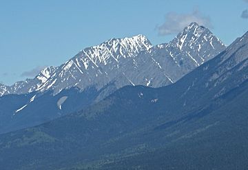
Mount Selkirk seen from Kootenay Valley Overlook along Highway 93
|
|
| Highest point | |
| Elevation | 2,930 m (9,610 ft) |
| Prominence | 320 m (1,050 ft) |
| Parent peak | Catlin Peak (2941 m) |
| Geography | |
| Location | Kootenay National Park British Columbia, Canada |
| Parent range | Mitchell Range Canadian Rockies |
| Topo map | NTS 82J13 |
| Geology | |
| Age of rock | Cambrian |
| Type of rock | Limestone |
Mount Selkirk is a tall mountain in British Columbia, Canada. It stands about 2,930 meters (9,613 feet) high. You can find it in the Vermilion River Valley. This mountain is right on the edge of Kootenay National Park. Many visitors to the park can see Mount Selkirk from Highway 93. This road is also called the Banff–Windermere Highway. Mount Selkirk is part of the Mitchell Range. This range is a smaller part of the huge Canadian Rockies. The mountain's closest taller neighbor is Catlin Peak, about 1.6 kilometers (1 mile) away.
Mountain's Name and History
Mount Selkirk got its name in 1886. George Mercer Dawson named it after Thomas Douglas, 5th Earl of Selkirk. He was a Scottish man who helped people move to Canada. He supported new settlements in what is now Manitoba. The official name for the mountain was accepted in 1924. This was done by the Geographical Names Board of Canada.
What Mount Selkirk is Made Of: Geology
Mount Selkirk is mostly made of a type of rock called Ottertail limestone. This rock formed a very long time ago. It was laid down during the Precambrian and Cambrian periods. Later, during an event called the Laramide orogeny, these rocks were pushed up. They moved east and even slid over younger rocks.
Weather Around Mount Selkirk: Climate
Mount Selkirk is in a subarctic climate zone. This means it has very cold and snowy winters. The summers are usually mild. Temperatures can drop below -20 °C (-4 °F). With wind, it can feel even colder, below -30 °C (-22 °F). Rain and melting snow from the mountain flow into streams. These streams eventually join the Vermilion River.
 | William L. Dawson |
 | W. E. B. Du Bois |
 | Harry Belafonte |


