
Mount Shand facts for kids
Quick facts for kids Mount Shand |
|
|---|---|

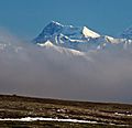
Mount Shand from the south
|
|
| Highest point | |
| Elevation | 12,660 ft (3,860 m) |
| Prominence | 1,560 ft (480 m) |
| Isolation | 2.23 mi (3.59 km) |
| Parent peak | Mount Moffit (13,020 ft) |
| Geography | |

Mount Shand
Location in Alaska
|
|
| Location | Southeast Fairbanks Census Area Alaska, United States |
| Parent range | Alaska Range Hayes Range |
| Topo map | USGS Mount Hayes C-5 |
Mount Shand is a tall, icy mountain peak in the eastern Alaska Range in the United States. It stands about 12,660 feet (3,859 meters) high. This makes it the third-highest peak in the Hayes Range, which is part of the larger Alaska Range.
Mount Shand is a remote mountain, meaning it's far away from cities. It's about 9.8 miles (15.8 kilometers) east-southeast of Mount Hayes. The city of Fairbanks is about 93 miles (150 kilometers) to its southeast. The mountain has three large, sweeping sides: the East, West, and South faces. It is not climbed very often.
Contents
Why is it Called Mount Shand?
This mountain is named after William Shand Jr. (1918–1946). He was a mountaineer, which is someone who climbs mountains. William Shand Jr. was the first person to successfully climb nearby Mount Moffit in August 1942. He also made the first climb of Mount Hayes on August 1, 1941.
How the Name Was Chosen
After William Shand Jr. passed away in a car accident, another mountaineer named Bradford Washburn suggested naming a mountain after him. Washburn had been part of the first team to climb Mount Hayes with Shand.
At first, the name "Mount Shand" was suggested for what is now called Mount Moffit. However, in 1961, the U.S. Geological Survey stepped in. They suggested applying the name "Mount Shand" to the current peak to avoid confusion, as two different names were being used for the same place. The name and the mountain's location were officially approved in 1962 by the U.S. Board on Geographic Names.
Climate Around Mount Shand
Mount Shand is located in a subarctic climate zone. This means the area has very long, cold, and snowy winters. The summers are usually mild, not too hot.
Glaciers and Weather
This type of climate helps support the large glaciers around the peak, like the Trident Glacier and Black Rapids Glacier. Temperatures on the mountain can drop below −4 °F (−20 °C). With wind, it can feel even colder, sometimes below −22 °F (−30 °C).
The best time to visit or try to climb Mount Shand is usually from May through June. During these months, the weather is often more favorable. The water from melting snow and ice on the mountain eventually flows into the Tanana River.
Images for kids
-
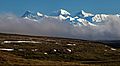
Mt. Shand (left), Mt. Moffit (center), McGinnis Peak (right)
-
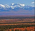
Mt. Shand from Denali Highway
-
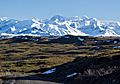
Mt. Shand centered in the distance
-
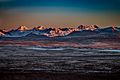
Left to right: Hayes, Moby Dick, Shand, Moffit
-
Mount Shand from the southeast


.jpg)

