Moby Dick (Alaska) facts for kids
Quick facts for kids Moby Dick |
|
|---|---|

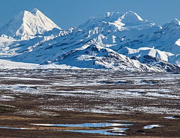
Moby Dick from the south
(Mount Hayes to left) |
|
| Highest point | |
| Elevation | 12,360 ft (3,770 m) |
| Prominence | 2,860 ft (870 m) |
| Isolation | 4.6 mi (7.4 km) |
| Parent peak | Mount Hayes (13,832 ft) |
| Geography | |
| Location | Southeast Fairbanks Census Area Alaska, United States |
| Parent range | Alaska Range Hayes Range |
| Topo map | USGS Mount Hayes C-6 |
| Climbing | |
| First ascent | 1964 |
Moby Dick is a tall, icy mountain peak in the eastern Alaska Range in the United States. It stands about 12,360 feet (3,767 meters) high. This mountain is covered in glaciers, which are like huge, slow-moving rivers of ice. It's located at the very top of the Trident Glacier.
Moby Dick is the fourth-highest peak in the Hayes Range, which is a part of the larger Alaska Range. This mountain is quite remote, meaning it's far away from towns. It's about 5.7 miles (9.2 kilometers) southeast of Mount Hayes and 92 miles (148 kilometers) southeast of Fairbanks. Another high mountain, Mount Shand, is about 4.7 miles (7.6 kilometers) to the east.
The first time people successfully climbed this mountain was in 1964. The team included Christopher Goetze, Lydia Goetze, Tom Knott, and Larry Muir. At that time, the mountain didn't even have an official name!
Mountain Climate
Moby Dick is in a subarctic climate zone. This means it has very long, cold, and snowy winters. The summers are usually mild, not too hot. This type of climate helps keep the big glaciers around the mountain, like the Trident, Susitna, and Black Rapids Glaciers, frozen and active.
Temperatures on the mountain can drop very low, sometimes even below −20 °C (−4 °F). When you add the wind, it can feel even colder, below −30 °C (−22 °F). The best time to visit or try to climb Moby Dick is usually from May through June. During these months, the weather is often more favorable. The water from melting snow and ice on the mountain flows into rivers like the Susitna and Tanana River.
 | William L. Dawson |
 | W. E. B. Du Bois |
 | Harry Belafonte |


