Mount Silverthrone (Alaska) facts for kids
Quick facts for kids Mount Silverthrone |
|
|---|---|

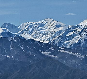
Mount Silverthrone from the north
|
|
| Highest point | |
| Elevation | 13,220 ft (4,030 m) |
| Prominence | 3,240 ft (990 m) |
| Listing |
|
| Geography | |
| Parent range | Alaska Range |
| Topo map | USGS Denali A-2 |
| Climbing | |
| First ascent | 1945, Bradford Washburn |
Mount Silverthrone is a tall, icy mountain peak in Denali National Park and Preserve, Alaska. It stands about 13,220 feet (4,030 meters) high. This impressive mountain is part of the Alaska Range and is located about 10.8 miles (17.4 km) east of Denali, North America's highest peak.
The first time someone successfully climbed to the top of Mount Silverthrone was on April 23, 1945. This historic climb was made by Bradford Washburn, a famous American explorer and mountaineer. The mountain got its name from a group of U.S. Army soldiers. They were testing cold weather gear and thought the mountain looked like a grand, silver "throne" at the head of the Brooks Glacier.
Contents
Mountain Climate and Weather
Mount Silverthrone is located in a very cold area known as a subarctic climate zone. This means it has long, snowy winters and cool summers. The weather here is greatly influenced by its high elevation and location in Alaska.
Temperatures and Wind Chill
During winter, temperatures on Mount Silverthrone can drop below −20 °C (which is about −4 °F). When the wind blows, it can make it feel even colder, with wind chill factors going below −30 °C (about −22 °F). These extreme conditions make the mountain a challenging place to visit.
Glaciers and Water Flow
The cold climate helps keep glaciers on the mountain's slopes, including the Brooks Glacier. When snow and ice melt, the water flows down the mountain. This water eventually drains into the McKinley River, which then joins the larger Tanana River system.
Best Time to Visit
If you want to see Mount Silverthrone or try climbing it, the months of May and June usually offer the best weather. During this time, the temperatures are a bit milder, and there's less chance of severe storms.
 | George Robert Carruthers |
 | Patricia Bath |
 | Jan Ernst Matzeliger |
 | Alexander Miles |


