
Mount Stimson facts for kids
Quick facts for kids Mount Stimson |
|
|---|---|

Mount Stimson
|
|
| Highest point | |
| Elevation | 10,147 ft (3,093 m) |
| Prominence | 4,382 ft (1,336 m) |
| Geography | |

Mount Stimson
Location in Montana

Mount Stimson
Location in the United States
|
|
| Location | Flathead County, Montana, U.S. |
| Parent range | Lewis Range |
| Topo map | USGS Mount Stimson |
| Climbing | |
| First ascent | J. Gordon Edwards and Alice Edwards (1951) and likely earlier |
| Easiest route | Hike/scramble (Class 3/4) |
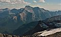
Mount Stimson is a very tall mountain in Glacier National Park, Montana, United States. It stands at about 10,147 feet (3,093 meters) high. This makes it the second highest peak in the entire park!
Mount Stimson is part of the Lewis Range, a long chain of mountains that runs through much of Glacier National Park. It's found in a quiet, faraway part of the park. The mountain is about 5 miles (8 kilometers) west of the Continental Divide. The Continental Divide is like a giant line across North America. It separates which ocean the rainwater flows into. Water on one side flows to the Pacific Ocean, and water on the other side flows to the Atlantic Ocean.
The mountain gets its water from Pinchot Creek on its south side and Nyack Creek on its other sides. Both of these creeks flow into the Middle Fork of the Flathead River.
Mount Stimson is named after Henry L. Stimson (1867–1950). He was an important person in the U.S. government. He served as the Secretary of State and twice as the Secretary of War. Mr. Stimson explored the area around Glacier National Park in the 1890s. He even helped George Bird Grinnell survey the land. He also strongly supported the idea of making this beautiful area a national park.
Why Mount Stimson is Special
Mount Stimson is known for how much it rises above the land around it. For example, its northwest side climbs over 6,200 feet (1,890 meters) from Nyack Creek in just 1.8 miles (2.9 kilometers). This makes it seem like a truly huge mountain!
It's also special because it's so far away from roads. Mount Stimson is one of the most isolated peaks in Glacier National Park. This means it's a quiet and wild place to visit.
Exploring Mount Stimson
The first climb of Mount Stimson that was officially recorded happened in 1951. J. Gordon Edwards and Alice Edwards were the climbers. However, they found signs that someone else had likely climbed it before them.
The most common way to climb Mount Stimson is called the West or Northwest Face Route. This path starts from Nyack Creek. There's a trail along Nyack Creek that hikers can use to get closer to the mountain.
The National Park Service warns that this trail is more wild and isolated than others in the park. You might find more bushes and trees along the path. There are also many streams to cross that do not have bridges. It's also important to be aware of wildlife like grizzly bears in this area, just like in the rest of the park.
The climbing route itself can be challenging. It starts with a long uphill hike through thick bushes. This part can take about three hours. After that, climbers face a mix of slopes and rocky cliffs. Other ways to climb the peak include the Southeast Spur and the Pinchot Creek Route from the south.
Images for kids
-
Aerial view of Mount Stimson's north side

