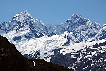
Mount Wilbur (Alaska) facts for kids
Quick facts for kids Mount Wilbur |
|
|---|---|

Mts Orville and Wilbur
|
|
| Highest point | |
| Elevation | 10,821 ft (3,298 m) |
| Prominence | 3,963 ft (1,208 m) |
| Geography | |
| Parent range | Fairweather Range, Saint Elias Mountains |
| Topo map | USGS Mount Fairweather C-4 Quadrangle |
| Climbing | |
| First ascent | 1975 by D. Jones, C. Gerhardt, C. McKibben |
| Easiest route | snow/ice climb |
Mount Wilbur is a tall mountain located in Glacier Bay National Park and Preserve in Alaska, U.S. It's part of the Fairweather Range, which is the southernmost section of the huge Saint Elias Mountains. This peak is about 14 miles (22 km) southeast of Mount Fairweather and 8 miles (13 km) northwest of Mount Crillon.
Mount Wilbur is one of two peaks, the other being Mount Orville. These mountains were named after the famous Wright Brothers, Orville and Wilbur, who invented the airplane. Even though Mount Wilbur isn't the tallest mountain in the world, it stands out a lot from the land around it. This is because it's very close to the ocean. The top of the mountain is only about 7.5 miles (12 km) from the water at the end of Lituya Bay to the southwest.
Contents
Exploring Mount Wilbur's Location
Mount Wilbur is found inside Glacier Bay National Park and Preserve. This park is a huge area of wilderness in southeastern Alaska. It's known for its amazing glaciers, tall mountains, and beautiful coastline.
Where is the Fairweather Range?
Mount Wilbur is part of the Fairweather Range. This mountain range is a sub-range of the larger Saint Elias Mountains. The Saint Elias Mountains stretch across parts of Alaska, Canada's Yukon Territory, and British Columbia. They are some of the highest coastal mountains in the world.
How High Does Mount Wilbur Stand?
Mount Wilbur reaches an elevation of 10,821 feet (3,298 meters) above sea level. While other mountains might be taller, Mount Wilbur looks very impressive because it rises sharply from the nearby flat land and the ocean. This makes it a very noticeable landmark in the area.
The Story Behind the Name
Mount Wilbur, along with its nearby peak, Mount Orville, got their names to honor two very important people in history.
Who Were the Wright Brothers?
The mountains are named after Orville and Wilbur Wright. These brothers were American pioneers of aviation. They are famous for inventing and building the world's first successful airplane. They made their first flight in 1903. Naming mountains after them celebrates their incredible achievement and their spirit of exploration.
Climbing Mount Wilbur
Mount Wilbur is a challenging climb, mostly covered in snow and ice. It attracts experienced climbers who are looking for an adventure.
When Was the First Ascent?
The first time anyone successfully climbed to the top of Mount Wilbur was in 1975. A team of climbers named D. Jones, C. Gerhardt, and C. McKibben made this historic climb. They used a route that involved climbing over snow and ice to reach the summit.
 | Georgia Louise Harris Brown |
 | Julian Abele |
 | Norma Merrick Sklarek |
 | William Sidney Pittman |


