
Mount William (Mount Duwil) facts for kids
Quick facts for kids Mount William(Mount Duwil) |
|
|---|---|

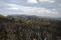
Looking east from Mount William, towards Ararat
|
|
| Highest point | |
| Elevation | 1,167 metres (3,829 ft) AHD |
| Geography | |

Mt William
Location in Victoria
|
|
| Location | Victoria, Australia |
| Parent range | Grampians |
| Topo map | Geoscience Australia Mount William |
| Climbing | |
| First ascent | Thomas Mitchell (European explorer) |
Mount William (also known as Mount Duwil) is a tall mountain in Australia. It is located in the state of Victoria, within the beautiful Grampians National Park. This mountain is about 250 kilometers (155 miles) west of Melbourne. It is a popular spot for visitors who want to see amazing views of the surrounding area.
Exploring Mount William
Mount William is the highest point in the entire Grampians National Park. It stands at 1,167 meters (3,829 feet) above sea level. This makes it a great place to see far and wide.
History of the Mountain
In 1836, a European explorer named Sir Thomas Mitchell was the first known European to reach the top of Mount William. Later, in 1840, a settler named Horatio Wills started a sheep farm near the mountain. He named a nearby peak Mount Ararat, which is now the name of a town.
Horatio's son, Tom Wills, grew up in this area. Tom became famous as a cricket player and a pioneer of Australian rules football. He spent his childhood living among the Djab Wurrung Aboriginal tribes of Mount William.
Visiting the Summit
At the very top of Mount William, you can see three tall towers. These are used for sending signals, including for amateur radio. There is a special road that goes all the way to the summit, but it is only for official vehicles and not for the public.
If you want to visit Mount William, you can drive to a car park partway up the mountain. From there, you will need to walk about 1.8 kilometers (1.1 miles) to reach the summit. This walk usually takes about 45 minutes for someone who is reasonably fit. You do not need a special permit to climb the mountain.
Gallery
-
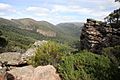
Western view from Mount William
-
Another western view from Mount William
-
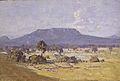
Mount William shown in Arthur Streeton's 1926 painting Land of the Golden Fleece


