Ararat, Victoria facts for kids
Quick facts for kids AraratVictoria |
|||||||||
|---|---|---|---|---|---|---|---|---|---|
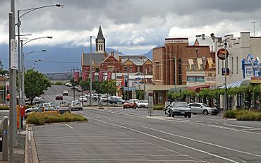
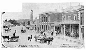
Barkly Street, looking east towards Mt Langi Ghiran
|
|||||||||
| Population | 8,500 (2021 census) | ||||||||
| • Density | 625/km2 (1,620/sq mi) | ||||||||
| Established | 1857 | ||||||||
| Postcode(s) | 3377 | ||||||||
| Elevation | 295 m (968 ft) | ||||||||
| Area | 13.6 km2 (5.3 sq mi) | ||||||||
| Location | |||||||||
| LGA(s) | Rural City of Ararat | ||||||||
| State electorate(s) | Ripon | ||||||||
| Federal Division(s) | Wannon | ||||||||
|
|||||||||
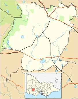
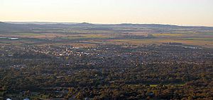
Ararat (also known as Tallarambooroo by the local Aboriginal people) is a town in Victoria, Australia. It is about 198 kilometres (123 miles) west of Melbourne. The town sits on the Western Highway, nestled among hills and valleys.
Ararat is the biggest town in the Rural City of Ararat area and serves as its main centre. In 2021, about 8,500 people lived in the town itself.
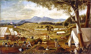
Ararat grew very quickly after gold was found there in 1857 during the Victorian gold rush. It was officially named a city on May 24, 1950. After a period of fewer people living there, the population has started to grow again. New projects, like the Hopkins Correctional Facility, are helping the town develop.
The town is named after Mount Ararat, which is 10 kilometres (6 miles) south-west. A politician named Horatio Wills gave the mountain its name in 1841. Interestingly, Ararat is the only city in Australia that was founded by Chinese people.
Contents
History of Ararat
Before Europeans arrived in Australia, the Djab wurrung Aboriginal people lived in the Ararat area. Many places around Ararat have names from their language. For example, 'Karangajaruk' means the valley where gold was found, and 'Butingitch' refers to the town site itself.
Europeans first settled in the Grampians region in the 1840s. Explorer Thomas Mitchell had passed through the area in 1836. In 1841, Horatio Wills was exploring and wrote in his diary that his group "rested like the Ark." He named a nearby hill Mt Ararat, and that's where the town's name comes from. The first post office opened in 1856.
In 1857, a group of Chinese miners were on their way to other gold fields when they discovered gold in Ararat. This discovery, called the Canton Lead, led to a huge boom for the town. The Chinese community became very important in Ararat. Today, the Gum San Chinese Heritage Centre celebrates their history.
Because of its fast growth, Ararat became an official town (a borough) on September 24, 1858. After the gold rush, Ararat became known for its large hospital, which opened in 1865. Later, a special part of the hospital, called J Ward, was created in 1887. This hospital closed in 1997, but you can now take tours there to learn about its past.
Swiss settlers started planting grapevines in Ararat in 1863, beginning the region's winemaking history.
Traditional Owners
The land where Ararat is located has been home to Aboriginal people for thousands of years.
- North-west of Campbell Street and the Pyrenees Highway, and north-east of the Western Highway and Lambert Street, the traditional owners are the Wotjobaluk, Jardwadjali, Wergaia, and Jupagalk nations. They are represented by the Barengi Gadjin Land Council Aboriginal Corporation.
- South-east of Campbell Street and the Pyrenees Highway, the traditional owners are the Djab Wurrung people.
- South-west of the Western Highway and Lambert Street, the Eastern Maar people are working with the Victorian Government to have their traditional ownership formally recognised.
Economy and Jobs
Ararat's economy relies on farming, especially wool and beef. The area is also known for its wine region, called the Grampians Wine Region.
- There are several wind farms nearby, like the Challicum Hills Wind Farm. These farms create a lot of clean, renewable energy.
- Ararat is also home to AF Gason Pty Ltd, a big Australian company that makes farm machinery and wood heaters.
The town also has many jobs in health and community services. It's a regional centre for shopping and business. The Hopkins Correctional Centre, a large prison, is located just outside the town.
Tourism is also growing in Ararat. Many visitors come to see the nearby Grampians National Park and visit local wineries. Key places to visit include:
- The Ararat Regional Art Gallery
- Mount Langi Ghiran winery
- Tours of Aradale, a historic hospital
- The Gum San Chinese Heritage Centre
- J Ward, a historic facility that offers tours.
Geography and Climate
Ararat is surrounded by beautiful mountain ranges. These include the Grampians National Park, Mount Langi Ghiran, Mount Cole, Mount Buangor, and the Pyrenees Ranges. Cemetery Creek flows through the northern part of the town, and Green Hill Lake is on the eastern edge.
Weather in Ararat
Ararat has a mild climate with warm summers and cool, often rainy, winters. It's known as a temperate Mediterranean climate.
| Climate data for Ararat Prison, elev. 295 m (968 ft), (1991–2020, extremes 1969–present) | |||||||||||||
|---|---|---|---|---|---|---|---|---|---|---|---|---|---|
| Month | Jan | Feb | Mar | Apr | May | Jun | Jul | Aug | Sep | Oct | Nov | Dec | Year |
| Record high °C (°F) | 43.1 (109.6) |
44.7 (112.5) |
39.0 (102.2) |
33.5 (92.3) |
26.2 (79.2) |
20.4 (68.7) |
21.0 (69.8) |
24.5 (76.1) |
28.9 (84.0) |
34.7 (94.5) |
39.8 (103.6) |
43.3 (109.9) |
44.7 (112.5) |
| Mean daily maximum °C (°F) | 27.8 (82.0) |
27.3 (81.1) |
24.4 (75.9) |
20.0 (68.0) |
15.7 (60.3) |
12.8 (55.0) |
12.1 (53.8) |
13.3 (55.9) |
15.7 (60.3) |
19.0 (66.2) |
22.3 (72.1) |
25.4 (77.7) |
19.7 (67.5) |
| Mean daily minimum °C (°F) | 11.6 (52.9) |
11.6 (52.9) |
9.7 (49.5) |
7.1 (44.8) |
5.3 (41.5) |
4.0 (39.2) |
3.4 (38.1) |
3.7 (38.7) |
5.1 (41.2) |
6.1 (43.0) |
7.9 (46.2) |
9.7 (49.5) |
7.1 (44.8) |
| Record low °C (°F) | 0.6 (33.1) |
0.3 (32.5) |
−0.9 (30.4) |
−5.7 (21.7) |
−5.2 (22.6) |
−6.4 (20.5) |
−7.3 (18.9) |
−6.2 (20.8) |
−4.0 (24.8) |
−4.5 (23.9) |
−4.5 (23.9) |
−1.0 (30.2) |
−7.3 (18.9) |
| Average rainfall mm (inches) | 37.5 (1.48) |
29.4 (1.16) |
23.6 (0.93) |
37.0 (1.46) |
48.6 (1.91) |
59.9 (2.36) |
57.8 (2.28) |
66.8 (2.63) |
58.2 (2.29) |
44.7 (1.76) |
44.6 (1.76) |
40.4 (1.59) |
548.6 (21.60) |
| Average rainy days (≥ 0.2 mm) | 6.8 | 5.8 | 7.8 | 9.6 | 13.5 | 16.7 | 17.5 | 17.3 | 14.4 | 11.9 | 9.9 | 8.3 | 139.5 |
| Average afternoon relative humidity (%) | 36 | 38 | 41 | 48 | 61 | 70 | 69 | 63 | 59 | 51 | 46 | 39 | 52 |
| Source: Australian Bureau of Meteorology | |||||||||||||
People of Ararat
In 2021, the town of Ararat had a population of 7,015 people. Across the whole Rural City of Ararat area, there were 11,880 residents.
- Most people (88%) living in Ararat were born in Australia.
- About 62% of people in Ararat identify as Christian. The Anglican and Catholic churches each have about 18% of the population.
How Ararat is Governed
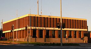
Ararat is the main town for the Rural City of Ararat local government area. This means the local council offices are located here.
- For national government, Ararat is part of the Division of Wannon.
- The town has a police station, a magistrates court, and a children's court, all on Barkly Street.
Education in Ararat
Ararat has several schools for different age groups:
- Primary Schools: Ararat Primary, Ararat West Primary, Ararat North Primary, and St Mary's Catholic Primary School. There are also several kindergartens.
- Secondary Schools: Ararat College and Marian College (a Catholic secondary school).
- Higher Education: Ararat also has campuses for Federation University Australia and Melbourne Polytechnic, offering university and vocational courses.
Culture and Fun
Art and Performance
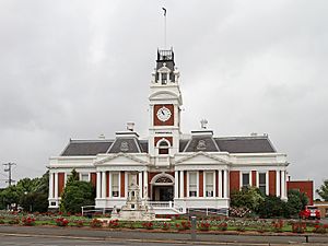
The old Ararat Town Hall is a beautiful building with a clock tower, built in 1899. It is now home to the Ararat Regional Art Gallery and the Ararat Performing Arts Centre. This is where people can enjoy art and live shows.
Sports in Ararat
Sports are very popular in Ararat:
- Australian Rules Football: The Ararat Football Club (formed in 1871) is a founding club of the Wimmera Football League. They won a championship in 2023! Another club, the Ararat Eagles, plays in the Mininera & District Football League.
- Netball: Like many country towns, netball is a popular sport for women. The Ararat Rats represent the city in the Wimmera Netball Association.
- Horse Racing: The Wimmera Racing Club holds several horse races each year at Ararat, including the Ararat Cup in November.
- Harness Racing: The Ararat Harness Racing Club also has regular races at its track.
- Golf: Golfers can play at the Aradale Golf Club or the Chalambar Golf Club.
- Motocross: This sport is growing in the area, and the Ararat Motorcycle Club hosts events.
- Gliding: The Grampians Soaring Club is a recreational gliding club that encourages young people and girls to learn to glide.
- Soccer: Soccer is played at a junior level through a school competition.
Festivals and Events
Ararat has two main festivals:
- Golden Gateway Festival: This community festival started in 1958 to celebrate 100 years since the city was founded.
- Jailhouse Rock Festival: Since 1994, this festival has celebrated the 1950s with a retro theme.
Places to Visit
Some popular places for tourists to visit in Ararat include:
- The Gum San Chinese Heritage Centre
- Aradale Lunatic Asylum Tours (historical tours)
- Langi Morgala Museum
- The Astor Cinema
- J Ward (historical tours, including ghost tours)
Transport and Services
Getting Around Ararat
Most people in Ararat travel by car. The town is located where several main roads meet:
- The Western Highway goes east to Ballarat and Melbourne, and west to Horsham and Adelaide.
- The Pyrenees Highway goes east to Avoca and Maryborough.
- Other roads connect to places like Halls Gap, Hamilton, Warrnambool, and Geelong.
- Ararat's streets are set up in a grid pattern.
Public Transport:
- Buses: Ararat Transit provides bus services on three routes, six days a week. These buses connect with train services.
- Taxis: Ararat Cabs offers taxi services, including a special bus for wheelchairs or larger groups.
Trains:
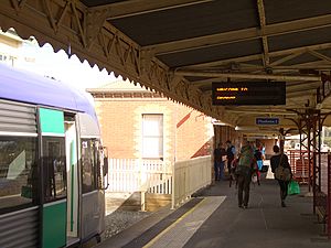
- Ararat has a railway station which is the end point for the Ararat V/Line rail service.
- Trains run twice a day to Ballarat (about 53 minutes) and on to Melbourne (about 2 to 2.5 hours).
- The long-distance train called The Overland also stops in Ararat twice a week, connecting Melbourne and Adelaide.
Airport:
- Ararat Airport (YARA) is located 5 kilometres (3 miles) south of the city. It is used for general aviation, which means smaller planes.
Water and Utilities
Water and wastewater services in Ararat are managed by GWMWater. The town gets its water from Mt Cole Reservoir and Lake Fyans, with other smaller reservoirs also part of the system.
Notable People from Ararat
Many interesting people have come from Ararat:
- Rob Borbidge – A politician who was the Premier of Queensland.
- Shane Kelly – An Olympic cyclist who won silver and bronze medals.
- Rene Kink – A famous Australian Rules footballer.
- Neil Murray – A singer-songwriter born in Ararat.
- Air Chief Marshal Sir Frederick Scherger – A high-ranking officer in the Royal Australian Air Force, born in Ararat in 1904.
- James Scobie – A well-known jockey and racehorse trainer.
- Geoff Todd – An artist.
- Ella Wood – An Australian Women's Rules footballer.
See also
 In Spanish: Ararat (Australia) para niños
 | Jessica Watkins |
 | Robert Henry Lawrence Jr. |
 | Mae Jemison |
 | Sian Proctor |
 | Guion Bluford |


