
Djab Wurrung people facts for kids
| Regions with significant populations | |
|---|---|
| Languages | |
| Djab Wurrung, English | |
| Religion | |
| Australian Aboriginal mythology | |
| Related ethnic groups | |
| Dja Dja Wurrung, Jardwadjali, Dhauwurd Wurrung and Wada wurrung see List of Indigenous Australian group names |
The Djab Wurrung people are Aboriginal Australians from central Victoria. Their traditional lands are volcanic plains, stretching from the Mount William Range in Gariwerd in the west to the Pyrenees range in the east. This area includes the Wimmera River and the start of the Hopkins River.
Towns like Ararat, Stawell, and Hamilton are located within their country. The Djab Wurrung Heritage Protection Embassy is a special place set up to protect important cultural sites near Ararat. Before European settlement, 41 Djab Wurrung clans formed strong alliances with the nearby Jardwadjali people. They shared culture, traded goods, and often married each other. Their lands were settled by Europeans but were never officially given away.
Contents
Understanding Djab Wurrung Language
The word "Djab Wurrung" means "soft language." It is part of the Western branch of the Kulin languages family. This language is spoken in the southernmost part of the Kulin language area.
To the east, people spoke Dja Dja Wurrung. To the north, from Casterton to Donald, people spoke Jardwadjali. Djab Wurrung shares many words with these languages. For example, it shares 85% of its vocabulary with Jardwadjali.
It is thought that a northern dialect called Knenknen Wurrung was once spoken by a different group. This group lived east of the Pyrenees and across northern Gariwerd. Later, their land and language became part of the larger Djab Wurrung territory.
Djab Wurrung Country
The Djab Wurrung lands cover a large area, about 2,700 square miles (7,000 square kilometers). They stretch from Mount Rouse in the west to Hamilton. To the east, their land reaches the Hopkins River and Wickliffe. The northern border is near Mount William, Stawell, Ararat, and the Great Dividing Range.
Important parts of Djab Wurrung country include the eastern ranges of Gariwerd, also known as the Grampians National Park. This area has always been very important to Djab Wurrung society and culture. Their territory extends from the Serra Range onto the plains south and east of the Gariwerd mountains.
Many different groups lived in specific parts of this land. For example, the Neetsheere balug lived at Mount William. The Kolorer gundij lived at Mount Rouse, an ancient volcano. The Djab Wurrung name for Mount Rouse is Kolorer, which means "lava." This shows their deep connection to the volcanic landscape.
Djab Wurrung Society and Culture
At the time Europeans arrived in the 1800s, there were about 41 Djab Wurrung clans or groups. Each group lived on its own smaller piece of land. They all spoke the Djab Wurrung language. Each group usually had between 40 and 60 people.
The total Djab Wurrung population was estimated to be between 2,460 and 4,920 people. Language and land connections were passed down from fathers. However, a special system based on two groups, the wirran (yellow-tailed black cockatoo) and grugidj (white cockatoo), was also very important. This system was passed down from mothers.
Clans often married people from other groups like the Dja Dja Wurrung and Dhauwurd wurrung. After European settlement, family relationships and connections to the wider land became even more important. This also meant that senior women gained more significance in the community.
Overall, Djab Wurrung society was organized in a way that connected people to their land. It also linked them to their families and other communities across the region. This allowed different groups to come together, for example, for seasonal hunting.
Trading Networks
The Djab Wurrung people worked together with other Aboriginal communities in western Victoria. This helped them use natural resources across the whole region. Goods of all kinds were traded between individuals and groups. This ensured that different resources from across south-east Australia could be shared as needed.
This trading system was based on a deep understanding of local environments. Different groups had special knowledge about their own areas. Eels were a very important trade item, but many other resources were also exchanged.
Bunjil's Shelter
Bunjil is a very important creator spirit or ancestor in Djab Wurrung culture. More than 90% of Aboriginal rock art in Victoria is found on Djab Wurrung and Jardwadjali country. Many of these sites are in the Grampians National Park.
One of the most important rock art sites is Bunjil's Shelter. It is located on Djab Wurrung country in the Black Range Scenic Reserve, near Stawell. Europeans knew about this site in the 1800s, but few had seen it. Its location became widely known in 1957.
For a while, some people thought the artwork might have been made by Europeans. However, scientific tests later confirmed that the paintings were made with traditional Aboriginal ochres. This proved that the rock art was indeed created by Aboriginal people.
Burial Rites
Some Djab Wurrung clans used to bury their dead in trees. Recent discoveries west of Ararat have shown examples of this practice. These discoveries include secondary tree burials, where the remains of two or more people were re-buried. A child was also found buried in a hollow tree near Stawell.
Land Management and Ecological Knowledge
The Djab Wurrung people had excellent ways of managing their land. This allowed them to have reliable natural resources. They often lived in permanent or semi-permanent villages with strong huts. These villages were usually near creeks, streams, or swamps. People lived there based on the seasons and what food was available.
In 1836, explorer Thomas Mitchell saw these huts near Mount Napier. He noted how well-built they were and how comfortable they could be in bad weather. Another explorer, George Augustus Robinson, described seeing many large, abandoned hut bases in 1841. Some were as big as 31 yards long.
Aquaculture
Aquaculture, which is like farming fish or eels, was a big part of Djab Wurrung life. They were among the first humans to practice aquaculture. They built fish traps and weirs (small dams) across rivers. These structures were common in the region.
In 1853, Charles Browning Hall described seeing many fish weirs near the Grampians. He saw low earth banks across shallow parts of the river with openings. In these openings, they placed long, circular nets made of rushes.
During early autumn, large groups of up to 1,000 people would gather. They would meet at the Mount William swamp or Lake Bolac for the yearly eel migration. Near Mount William, an amazing system of channels, weirs, and eel traps was built. This showed that people lived a settled life, and eels were important for food and trade.
Fire Management
The Djab Wurrung used fire to manage their land. This helped them grow plant foods like Murnong. They would carefully burn certain areas of land. This removed unwanted plants, fertilized the soil with ash, and allowed sunlight to reach the ground. This ensured a good harvest by spring.
The rich pasture created by these controlled burns also attracted animals for hunting. This careful use of fire was a key part of their land management. When European settlement disrupted these practices, it may have contributed to an increased risk of bushfires in the region.
History of the Djab Wurrung
.jpg)
The ancestors of the Djab Wurrung people have lived on their lands for a very long time, possibly up to 40,000 years. The oldest known site of human activity in Gariwerd is about 22,000 years old.
The Djab Wurrung likely knew about European settlers from other coastal Aboriginal groups. Their first recorded direct contact was in September 1836. Major Thomas Mitchell met two women and their children near Mount Cole. Two years later, in 1838, European settlers and their sheep began to arrive on Djab Wurrung country.
The Djab Wurrung people resisted this settlement. They sometimes drove off or took sheep. Settlers often responded with violence. Between 1840 and 1859, there were reports of many conflicts and killings of Djab Wurrung people. Most of these happened before the end of 1842. Few settlers were brought to court for these actions.
Despite the challenges, the Djab Wurrung continued to connect with their land and culture. On the Campbell brothers' farm, settled in 1840, some clans were allowed to stay. They were given food and clothing, which helped reduce conflict. Evidence shows these clans kept their connection to their land, culture, and traditional foods into the 1860s.
By 1845, the Djab Wurrung population had dropped significantly. Many people died from new diseases, lack of traditional foods, and conflicts. During the gold rush, many Europeans and Chinese people came to their land. Djab Wurrung people often found work on farms during this time.
In the 1870s, many Djab Wurrung people were moved to special reserves. For example, people from Hamilton went to Lake Condah, and those from Mount Cole went to Framlingham mission and Coranderrk station.
Djab Wurrung Football
It is believed that a traditional Aboriginal ball-kicking game, like Marn Grook, might have influenced the creation of Australian rules football. James Dawson, a pastoralist and Aboriginal rights activist, described how the Djab Wurrung played their game.
They used a ball made from stitched possum skin. Fifty to one hundred players would join in. The players were divided into two teams, often based on their "cockatoo" groups (white cockatoo against black cockatoo). Each team tried to keep the ball, tossing it a short distance by hand and then kicking it in any direction. The team that kicked it most often and furthest won. The player who kicked it highest was considered the best.
Tom Wills, a key figure in Australian Rules football, grew up near Ararat around 1840. He often played with local Aboriginal children and learned their language. He later helped create and set the rules for Australian Rules football. Whether Marn Grook directly influenced the game is still discussed today.
Djab Wurrung Today
Gariwerd and the Grampians National Park
In 1989, there was a plan to rename many places in the Gariwerd area using Djab Wurrung names. Many people in the community disagreed with this. The Brambuk centre, which represents five Aboriginal communities linked to the area, suggested using both names, like Gariwerd/Grampians.
Some of the proposed changes included:
- Grampians to Gariwerd (mountain range)
- Mount Zero to Mura Mura (little hill)
- Halls Gap to Budja Budja.
After a two-year discussion, the park was renamed Grampians (Gariwerd) National Park in 1991. However, this was changed back in 1992. Later, a system of using both names for geographical features was brought back. Now, the Australian National Heritage List refers to "Grampians National Park (Gariwerd)."
The Brambuk National Park and Cultural Centre in Halls Gap is owned and run by Jardwadjali and Djab Wurrung people. It represents five Aboriginal communities with historical ties to the Gariwerd-Grampians ranges.
Sacred Trees and Djab Wurrung Embassy
In 2012, road authorities planned to upgrade the Western Highway. An Aboriginal group, Martang, approved the project. However, it was later found that many important roadside trees, considered sacred by Djab Wurrung people, were not protected.
Protesters set up the Djab Wurrung Heritage Protection Embassy in 2018. They camped near the roadworks to stop the removal of these culturally significant trees. In October 2020, a court ordered a temporary halt to the work.
The Eastern Maar Aboriginal Corporation, which now represents Djab Wurrung interests, has worked to save 16 culturally important trees. These include two "birthing trees" and other special trees. However, some people, like Senator Lidia Thorpe, believe that the processes for protecting Aboriginal heritage need to be more open and fair.
In 2020, a 350-year-old Yellow Box tree, known as the Directions Tree, was cut down during the road upgrade. This caused further concern and discussion about protecting sacred sites.
Alternative names
- Bolagher
- Bolakngat
- Buninjon, Buninyong
- Girriwurra
- Hopkins River Tribe
- Knindowurong
- Kolor, Kolor Kuurndit, Kooloor, Kolorer
- Nutcheyong
- Pirt-kopan-noot
- Punoinjon
- Purteet-chally
- Tyapwuru, Tyapwurru, Chaap Wuurong, Chaapwurru, Djabwuru
Images for kids
-
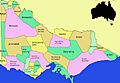
Map of Victorian Aboriginal language territories
