
Mount Williwaw facts for kids
Quick facts for kids Mount Williwaw |
|
|---|---|

Mount Williwaw seen from Mt. Elliott
|
|
| Highest point | |
| Elevation | 5,445 ft (1,660 m) |
| Prominence | 3,245 ft (989 m) |
| Geography | |

Mount Williwaw
Location in Alaska
|
|
| Location | Chugach State Park Anchorage Municipality, Alaska United States |
| Parent range | Chugach Mountains |
| Topo map | USGS Anchorage A-7 |
| Climbing | |
| First ascent | 1965 |
| Easiest route | Scrambling class 3 |
Mount Williwaw is a very tall mountain in the Chugach Mountains of Alaska, a state in the United States. It stands at 5,445-foot (1,660 m) high. This impressive peak is the highest point in the Chugach Front Range.
You can find Mount Williwaw inside Chugach State Park, about 12 mi (19 km) southeast of downtown Anchorage. It's also 1.4 mi (2 km) northeast of a place called The Ramp. Below the mountain, on its north and west sides, are the beautiful Williwaw Lakes. These lakes are great spots for campers who want to break up their climb to the summit.
The mountain got its name in 1964. The United States Geological Survey officially adopted it after the Mountaineering Club of Alaska suggested it. The name comes from a powerful, sudden wind called a williwaw. In May 1962, an army group from nearby Fort Richardson was caught in a severe williwaw near this mountain. The conditions were extremely tough, and some members of the group became very ill before they were rescued.
The very first time someone successfully climbed Mount Williwaw was on June 11, 1965. The climbing team included David Judd, M. Judd, Myers, and Parker. They reached the top by following the South Ridge.
Weather and Climate
Mount Williwaw is located in a subarctic climate zone. This means the area has long, very cold, and snowy winters. Summers are usually mild. During winter, temperatures can drop below −20 °C (which is about -4 °F). With the wind chill, it can feel even colder, sometimes below −30 °C (about -22 °F).
Water from the melting snow and ice on the mountain flows into Ship Creek and Campbell Creek.
Images for kids
-
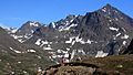
Mt. Williwaw to right
-
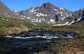
Mt. Williwaw in background
-
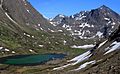
Williwaw Lake with Mt. Williwaw to right
-
Mt. Williwaw seen from Mount Elliott
.jpg)
.jpg)
.jpg)
.jpg)
