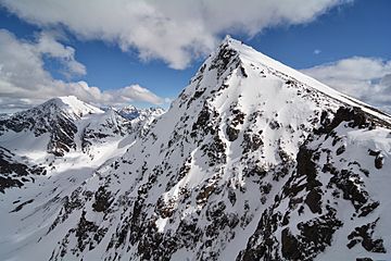
The Ramp (Alaska) facts for kids
Quick facts for kids The Ramp |
|
|---|---|
 |
|
| Highest point | |
| Elevation | 5,240 ft (1,600 m) |
| Prominence | 740 ft (230 m) |
| Parent peak | Mount Williwaw |
| Geography | |
| Location | Chugach State Park Anchorage Municipality, Alaska United States |
| Parent range | Chugach Mountains |
| Topo map | USGS Anchorage A-7 |
| Climbing | |
| Easiest route | Hiking class 2 |
The Ramp is a cool mountain in Alaska, standing tall at 5,240 feet (about 1,597 meters). It's part of the amazing Chugach Mountains and is located near Anchorage. This mountain got its official name in 1981. It's a popular spot for hikers and adventurers!
The Ramp is a mountain that reaches 5,240 feet (which is about 1,597 meters) into the sky. It's located in the Chugach Mountains in Anchorage Municipality, Alaska. The name "The Ramp" was officially chosen and adopted in 1981 by the United States Geological Survey. This means it's the recognized name on maps and for official records.
This mountain is found inside Chugach State Park. It is about 12 miles (19 kilometers) southeast of downtown Anchorage. The Ramp is also about 1.42 miles (2.29 kilometers) southwest of Mount Williwaw, which is a taller peak nearby. You can reach The Ramp by using the Powerline Trail, which is a path often used by hikers.
Mountain Climate
The climate at The Ramp is known as a subarctic climate. This means it has very long, cold, and snowy winters. The summers, however, are usually mild and pleasant.
Winter Weather
During winter, temperatures can drop below −20 °C (which is −4 °F). With the wind chill, it can feel even colder, sometimes below −30 °C (−22 °F). Wind chill makes the air feel colder than the actual temperature because of the wind.
Water Flow
When it rains or snows, the water from the top of The Ramp flows down the mountain. This water eventually drains into two nearby streams: Ship Creek and Campbell Creek.
 | Claudette Colvin |
 | Myrlie Evers-Williams |
 | Alberta Odell Jones |


