Mousa facts for kids
| Norse name | Mósey (Norwegian: Mosøy) |
|---|---|
| Meaning of name | Old Norse: moor or mossy island |
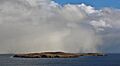
.jpg) A snow shower over Mousa |
|
| OS grid reference | HU460240 |
| Coordinates | 60°00′N 1°10′W / 60.00°N 1.17°W |
| Physical geography | |
| Island group | Shetland |
| Area | 180 hectares (0.69 sq mi) |
| Area rank | 115= |
| Highest elevation | 55 metres (180 ft) |
| Administration | |
| Sovereign state | United Kingdom |
| Country | Scotland |
| Council area | Shetland Islands |
| Demographics | |
| Population | 0 |
Mousa (Old Norse: Mosey, meaning "moss island") is a small island in Shetland, Scotland. No one has lived on the island since the 1800s. Mousa is famous for the Broch of Mousa, an ancient round tower from the Iron Age. It is also a special protected area for storm-petrels, which are small seabirds that nest there.
Contents
Exploring Mousa's Geography

Mousa is located about one mile off the east coast of Mainland Shetland. It's about 15 kilometers (9 miles) south of Lerwick. The island is nearly split in two by two narrow inlets called East and West Hams. Mousa is about 2.4 kilometers (1.5 miles) long and almost 1.6 kilometers (1 mile) wide.
The island's ground is made of hard sandstone and muddy limestone. This mix creates very fertile soil. In the past, a quarry on Mousa provided flat stones for building in Lerwick.
Plants and Nature on Mousa
Mousa's rich soil helps many different plants grow. You can find plants like sheep's-bit and creeping willow. These grow well in the grassy areas, even with strong winds and salty sea spray. Sheep also graze on the island, which helps keep the plants healthy.
How the Norse Saw Mousa
The Norse people used to think of an island as something they could sail all the way around. This included being able to drag a boat over land if needed. Because of this, they thought Mousa was actually two islands. They called them North Isle and South Isle.
Mousa is located exactly on the 60th parallel north. This means it is 60 degrees north of the equator. It is also 30 degrees south of the North Pole.
Mousa's Ancient History


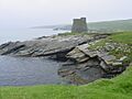
The Broch of Mousa is the best-preserved Iron Age fort in all of the British Isles. This round tower is 2,000 years old. It stands tall above the rocky shoreline. It was one of two brochs that guarded Mousa Sound. These brochs might have been part of a chain of towers in Shetland. They could have been used as beacons, visible from one to another. The other broch, at Burland on the Mainland, is not as well preserved.
Many brochs were the center of a settlement. However, archaeologists have not fully explored Mousa Broch to confirm this. It was cleared out in 1860 and again in 1919. Mousa Broch has stayed almost perfectly intact. It is thought to be nearly as tall today as it was when it was first built. It was lucky because its stones were not taken to build nearby walls or houses.
Mousa in Old Stories
Mousa is mentioned in the Orkneyinga Saga. This old Norse story tells how the island was used. People used it as a safe place during invasions. It was also a secret hideout for lovers.
Inside the Broch of Mousa
The entrance passage into Mousa Broch is very long. This shows how incredibly thick its walls are. At its base, the broch is 15 meters (49 feet) across. But the inside space is only 6 meters (20 feet) wide. Inside the huge walls, there are many small rooms. These were probably used for storage. Higher up, passages run between the inner and outer parts of the wall.
On the inside, a steep set of steps leads to the top of the wall. Halfway up, there is a landing. This landing probably gave access to an upper floor inside the broch. This floor would have been built on a ledge around the inside of the tower.
Protecting Mousa's Wildlife

Mousa is a great place to see many animals. You can find grey seals and common seals here. Many birds also live on the island. These include black guillemots, Arctic terns, and storm-petrels.
Storm-Petrel Breeding and Conservation
Mousa is home to about 6,800 pairs of European storm-petrels that come to breed. This is about 8% of all storm-petrels in Britain. It's also about 2.6% of the world's population! Because of this, the island is a Special Protection Area (SPA). It is also a Site of Special Scientific Interest (SSSI). These protections are managed by NatureScot. The island is also run as a nature reserve by the RSPB.
Protecting the Seas Around Mousa
The seas around Mousa are also very important. They have a large population of sandeels. Sandeels are small fish that are food for many other animals. These include bigger fish, seabirds, seals, whales, and dolphins. The seas around Mousa are thought to have the most reliable sandeel population in all of Shetland. Because of this, these seas are also protected. They are a Special Area of Conservation (SAC) and a Nature Conservation Marine Protected Area (NCMPA).
Storm-petrels can also be found at the nature reserve of Haaf Gruney.
Getting to Mousa
You can easily visit Mousa by taking a ferry. This ferry is for passengers only. It runs from Leebitton, Sandwick on the Shetland Mainland. The ferry operates during the summer months.
See also
 In Spanish: Mousa para niños
Images for kids
-
A snow shower over Mousa
-
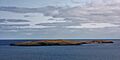
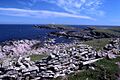
Mousa as seen from the mainland; the broch is visible on the right.
-
A misty day at Mousa Broch.
-
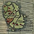
Shetland and Mousa on the Carta Marina in 1539.
-
The east coast of Mousa towards the Peerie Bard.
-