Municipal Borough of Barking facts for kids
| Barking Barking Town (1882–1931) |
|
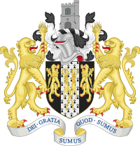
| Motto: Dei gratia sumus quod sumus (By the grace of God we are what we are) |
|
 |
|
 |
|
| Geography | |
| Status | Local board district (1882–1894) Civil parish (1888–1965) Urban district (1894–1931) Municipal borough (1931–1965) |
| 1911 area | 3,805 acres (15.4 km2) |
| 1931 area | 3,809 acres (15.4 km2) |
| 1961 area | 3,877 acres (15.7 km2) |
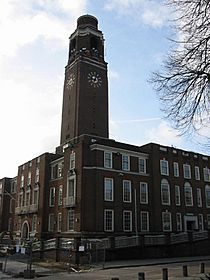
| HQ | Barking Town Hall, Clockhouse Avenue |
| History | |
| Origin | Barking ancient parish |
| Created | 1882 |
| Abolished | 1965 |
| Succeeded by | London Borough of Barking London Borough of Newham |
Quick facts for kids Demography |
|
|---|---|
| 1911 population - 1911 density |
31,294 8.2/acre |
| 1931 population - 1931 density |
51,270 13.5/acre |
| 1961 population - 1961 density |
72,293 18.6/acre |
| Politics | |
| Governance | Barking Town Local Board (1882–1894) Barking Town Urban District Council (1894–1931) Barking Borough Council (1931–1965) |
 |
|
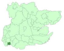
Barking was an area in Essex, England, that had its own local government from 1882 to 1965. For part of this time, from 1882 to 1931, it was known as Barking Town. This area included the main town of Barking, the eastern part of Beckton, and a section of the Becontree housing estate.
Barking was part of the Metropolitan Police District, which meant it was policed by the same force as London. Its population grew steadily over the years. Today, the former area of Barking is split between two parts of Greater London: the western side of the London Borough of Barking and Dagenham and the very eastern edge of the London Borough of Newham.
Contents
Barking's Early History and Divisions
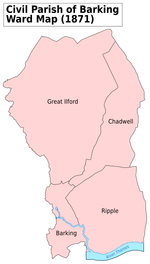
The old area of Barking was very large, covering about 12,307 acres (around 50 square kilometers). It was the biggest parish in Essex. A "parish" is an old term for a local area, often linked to a church.
This large area was divided into four smaller parts, called wards:
- Town ward: This covered the land right next to the River Roding.
- Ripple ward: This stretched from Longbridge Road in the north down to the River Thames in the south. It included Creekmouth and part of the modern Becontree estate.
- Chadwell ward: This was to the northeast and included places like Goodmayes and parts of Chadwell Heath.
- Great Ilford ward: This was to the northwest and included areas like Barkingside, Clayhall, and Ilford.
How Barking's Government Was Formed
In 1882, a special group called a "local board" was set up for the Town ward. This board helped manage local services like health and sanitation. By 1885, its area was expanded to include the Ripple ward.
In 1888, the large Barking parish was made smaller. The Chadwell and Great Ilford wards left to form a new parish called Ilford. Barking's size then matched the area managed by its local board.
Later, in 1894, a new law called the Local Government Act 1894 changed things. The area managed by Barking's local board officially became the Barking Town Urban District within Essex. At the same time, the Ilford parish became the Ilford Urban District.
Becoming a Borough
In 1931, Barking Town Urban District gained a higher status and became a "municipal borough." This meant it had more power to manage its own affairs. At this point, its name was shortened to just Barking.
The borough even ran its own tram services, known as the Barking Town Urban District Council Light Railways. However, in 1933, these trams became part of the larger London Passenger Transport Board.
Barking Borough shared borders with several other areas:
- To the west, it bordered East Ham.
- To the north, it bordered Ilford.
- To the east, it bordered Dagenham.
- To the south, the borough met the River Thames. Across the river was the Metropolitan Borough of Woolwich, which was part of the County of London.
The End of Barking as a Separate District
In the 1920s, a huge housing area called the Becontree estate was built across parts of Ilford, Barking, and Dagenham. Because of this, people often discussed how local government in the area should be organized.
By 1957, Barking and its neighbors were considered part of the larger London area. A group called the Royal Commission on Local Government in Greater London was set up to review how London's local governments worked. In 1960, this group suggested that Barking and Dagenham should join together to form one new area.
Following these recommendations, a new law, the London Government Act 1963, was passed. In 1965, this law officially ended the municipal boroughs of Barking and Dagenham. Their areas were moved from Essex to Greater London. Most of the former Barking borough joined with Dagenham to create the London Borough of Barking and Dagenham. However, the part of Barking west of the River Roding, near Beckton, became part of the London Borough of Newham.
 | Bayard Rustin |
 | Jeannette Carter |
 | Jeremiah A. Brown |


