Municipal Borough of Hendon facts for kids
| Hendon | |
| Motto: Endeavour | |
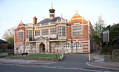
 Hendon Town Hall |
|
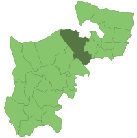
 Hendon within Middlesex in 1961 |
|
| Geography | |
| Status | Urban district (1894-1932) Municipal borough (1932-1965) |
| 1894 area | 8,382 acres (34 km2) |
| 1965 area | 10,369 acres (42 km2) |
| HQ | Hendon Town Hall |
| History | |
| Created | 1894 |
| Abolished | 1965 |
| Succeeded by | London Borough of Barnet |
Quick facts for kids Demography |
|
|---|---|
| 1901 population | 22,450 |
| 1961 population | 151,843 |
 |
|
Hendon was once a large area in England, covering about 8,250 acres (33.4 km²). It included places like Mill Hill, Golders Green, and Childs Hill. For a long time, it was known as a "civil parish," which is a local area with its own government.
In 1894, Hendon became an "urban district" in Middlesex. This meant it had its own local council to manage things like roads and public health. Later, in 1932, it became an even bigger area called a "municipal borough." This gave it more power to make decisions for its residents. However, in 1965, the municipal borough of Hendon was officially ended. Its area then became part of the new London Borough of Barnet, which is how it is known today.
Contents
Hendon's Past: A Look Back
Early History of Hendon
The name Hendon might come from old words meaning "high hill" or "old hill." The earliest time we know of the name being used was in the year 1005, when it was called "Heandunigna." Hendon was part of a larger area called the Hundred of Gore, located in the county of Middlesex.
For many years, local churches and landowners managed most things in the area. But over time, the government took over more responsibilities. In 1894, Hendon became an "urban district," meaning it had its own local council. Then, in 1932, it joined with the nearby area of Edgware to form a "municipal borough." This new borough had its own special symbol, a coat of arms, to represent it.
What Was the Poor Law Union?
Between 1835 and 1930, Hendon was part of something called a "Poor Law Union." This was a group of parishes (local areas) that worked together to help people who were very poor and needed support. It was a way for communities to look after those who couldn't support themselves. Many different parishes, including Hendon, were part of this union.
How Hendon Grew Over Time
People have lived in Hendon for a very long time. There's even proof of Roman activity here, and an old Roman road called Watling Street runs along its western side. In 1087, the area of Hendon Manor was recorded in the Domesday Book, showing it belonged to Westminster Abbey.
For centuries, much of the local economy involved woodlands, which provided wood and a place for pigs to live. An old road leading out of London, passing through places like Hampstead and Mill Hill, was also very important for travel and trade. In the 17th century, Hendon became known for its hay.
A big change happened in 1868 when a train station opened in Hendon. This made it easier for people to travel and encouraged new homes to be built in the 1880s and 1890s. The first factory in Hendon, the Pyramid and Fairy light works, opened in 1885.
Even more growth came between 1906 and 1924 with the arrival of trams and the underground train (tubes). This meant people could easily travel to work in central London, and workers could also come into Hendon for jobs. By the 1930s, Hendon was a busy industrial area. Famous companies like Schweppes (known for drinks), Johnson's Photographic Ltd, and Handley Page (who made airplanes) had factories here.
After World War II, many new houses were needed. This led to industries moving out of Hendon, and the area became mostly residential, a place where people lived rather than worked in factories.
Hendon is also famous for Hendon Aerodrome, an airfield started by Claude Grahame-White in 1911. It was an important place for early aviation.
Hendon's Population Growth (1801–1961)
| Population changes in Hendon 1801–1961 | |||||||||||||||||||||||||||||||||||||||||||||||||||||||||||
|---|---|---|---|---|---|---|---|---|---|---|---|---|---|---|---|---|---|---|---|---|---|---|---|---|---|---|---|---|---|---|---|---|---|---|---|---|---|---|---|---|---|---|---|---|---|---|---|---|---|---|---|---|---|---|---|---|---|---|---|
|
|
|
|||||||||||||||||||||||||||||||||||||||||||||||||||||||||
| Source(s): Hendon CP/AP 1801–1961. Hendon MB/UD 1911–1961. | |||||||||||||||||||||||||||||||||||||||||||||||||||||||||||
Hendon's Coat of Arms
When Hendon became a municipal borough in 1932, it was given its own Coat of arms. A coat of arms is a special design that represents a family, city, or organization. Hendon's coat of arms had:
- A blue shield with a lamb on a green hill.
- A gold band at the top with two windmill sails.
- A special symbol above the shield: a two-bladed airplane propeller with wings. This showed Hendon's connection to aviation and the Hendon Aerodrome.
- Two creatures on the sides: a griffin (a mythical creature with the body of a lion and wings of an eagle) and a pegasus (a mythical winged horse). These creatures also had crowns around their necks.
Areas Within Hendon
Hendon included many different areas that you might know today:
- Brent Street (Hendon)
- The Burroughs (Hendon)
- Childs Hill
- Church End (Hendon)
- Clitterhouse
- Colindale
- Edgware
- Golders Green
- Grahame Park
- Hendon Central (Hendon)
- Holders Hill
- Mill Hill
- Parson Street (Hendon)
- Temple Fortune
- West Hendon
Some areas were shared with other parishes (local districts):
 | Aaron Henry |
 | T. R. M. Howard |
 | Jesse Jackson |


