
Munroe Island facts for kids
|
Native name:
Munrothuruthu
|
|
|---|---|

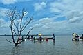
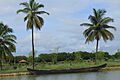
Lake Ashtamudi at Munroe Island
|
|

Munroe Island
Location in Kerala
Location in Kerala, India
|
|
| Etymology | In honour of Col. John Munro |
| Geography | |
| Location | Ashtamudi Lake in India |
| Coordinates | 9°0′0″N 76°37′0″E / 9.00000°N 76.61667°E |
| Archipelago | Islands of Kollam |
| Adjacent bodies of water | Lake Ashtamudi |
| Total islands | 8 |
| Major islands | Munroe Island,Perungalam, Pattamthuruth, Pezhumthuruth |
| Area | 13.37 km2 (5.16 sq mi) |
| Administration | |
| Largest Metropolis | Kollam (Quilon) (pop. 397419) |
| Demographics | |
| Population | 10380 (2011) |
| Pop. density | 776 /km2 (2,010 /sq mi) |
| Ethnic groups | Malayali |
| Additional information | |
| Time zone |
|
| The nearest Railway Station is Munroturuttu railway station. | |
Munroe Island (also called Mundrothuruthu) is a beautiful group of islands in Kerala, South India. It is located where the Ashtamudi Lake and the Kallada River meet. This area is part of the Kollam district.
The island group is made up of eight small islands. Together, they cover about 13.4 square kilometers. You can reach the island by road, train, or boat. It is about 25 kilometers from Kollam city. In 2011, about 9,599 people lived in the main village of Mundrothuruth. Sometimes, people call this place the "Sinking Island of Kerala."
The island is named after Colonel John Munro, who was an important British official. He worked for the old Princely State of Travancore.
Contents
Discovering Munroe Island's Past
In 1795, the British took control in South India. The state of Travancore then came under their rule. From 1800, a British official called a "Resident" managed Travancore.
Colonel John Munro was one of these Residents. During his time, he helped create new land where the Kallada River meets Ashtamudi Lake. This new land became the island, and it was named after him.
The Historic Dutch Church
Munroe Island is home to the Dutch Church. This is one of the oldest churches in Kerala. It was built by the Dutch in 1878. The church is made of red bricks. It mixes Dutch and Kerala building styles. It sits on the pretty banks of Ashtamudi Lake.
For a long time, many villagers made a living by making coir from coconuts. Coir is a strong fiber used for ropes and mats. After the 2004 Indian Ocean tsunami, things changed for the people living here.
Exploring Munroe Island: A Tourist's Guide
Munroe Island is a popular place for visitors. It offers many interesting sights and activities. You can learn about how coir is made. You can also watch people weaving coir.
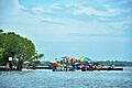
Visitors can see local fishing activities. They can also watch prawns being fed. The island is a great spot for seeing migratory birds. You can explore narrow canals and waterways by boat. There are also beautiful coconut farms along the lake. You will find lagoons and mangrove plants. The tiny islands of Pathupara are also a lovely sight.
The Famous Kallada Boat Race
The Kallada Boat Race is one of Kerala's most famous boat races. It takes place near Munroe Island. The race is held at Karuvathrakadavu-Muthiraparambu nettayam. It is an exciting event to watch.
Understanding the "Sinking Island" Idea
Some people worry that parts of Munroe Island are sinking. This is because low-lying areas sometimes get covered by high tides. In 2016, experts from a college in Kollam started studying this. They wanted to understand why this was happening.
What Scientists Found
Later, scientists from the National Centre for Earth Science Studies (NCESS) did a two-year study. They used special satellite tools and GPS stations. Their findings were interesting. They said that the island itself is not sinking.
They found that only very heavy buildings might have sunk a little. This happened if they were not built correctly. The railway lines and station platforms also showed some sinking. This is likely because many trains (up to 150 a day) pass over them.
The scientists also found that global warming is not the main problem here. A very high tide on the coast does not cause a very high tide on Munroe Island.
Challenges for Residents
Even though the island is not sinking, people have faced challenges. Many people have moved away from the island. They find it hard to live there. This has caused land prices to drop.
The Indian Ocean tsunami in 2004 might have made things worse. It changed the water system in the backwaters. This led to more salt in the soil. This makes it harder for plants to grow and affects farming.
Gallery
-
Saambranikkodi of Munroe Island
-
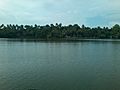
Munroe island in Ashtamudi Lake
-
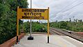
Munroe island railway station
-

Saambranikkodi boat jetty
-
Saambranikkodi at Munroe island
-

-
-
Uninhabited island in Munroe
-
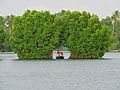
Tourism in Munroe Island.


See also
 In Spanish: Isla Munroe para niños
