
Namchi district facts for kids
Quick facts for kids
Namchi district
|
|
|---|---|
|
District of Sikkim
|
|
.jpg)
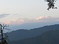
Mountain view at Ravangla in Namchi district, Sikkim
|
|
| Country | |
| State | |
| Headquarters | Namchi |
| Area | |
| • Total | 750 km2 (290 sq mi) |
| Population
(2011)
|
|
| • Total | 146,850 |
| • Density | 195.8/km2 (507/sq mi) |
| Time zone | UTC+05:30 (IST) |
| ISO 3166 code | IN-SK |
| Vehicle registration | SK-04, SK-05 |
Namchi District is a special area, or district, in the Indian state of Sikkim. Its main office, or headquarters, is in the town of Namchi.
Contents
Exploring Namchi District
Namchi district is located in the southern part of Sikkim. Most of the year, it has a mild climate. This is because it sits at an altitude of 400 to 2000 meters (about 1,300 to 6,500 feet).
Some of the main towns you can find here are Namchi, Ravangla, Jorethang, and Melli.
Nature's Special Places
The district is home to the Maenam Wildlife Sanctuary. This is a protected area where animals and plants can live safely.
How Namchi District Makes Money
Namchi district is the most developed area in Sikkim when it comes to industries. This is because it has more flat land available. The ground here is also very stable. This means the roads are usually in good condition. Other parts of the state often have problems with landslides.
The district is also famous for its special Sikkim tea. This tea is grown in gardens near the town of Namchi.
People of Namchi District
According to a survey in 2011, Namchi district has about 146,850 people. This is roughly the same number of people as in the country of Saint Lucia. This makes it one of the less populated areas in Sikkim.
About 196 people live in each square kilometer of the district. Between 2001 and 2011, the number of people living here grew by about 11.57%. For every 1000 males, there are 914 females. Also, about 82 out of every 100 people can read and write.
Most people in Namchi district are of Nepali background. Other groups include the Lepcha and Bhutia communities. Nepali is the most common language spoken here.
Beliefs and Religions
| Religion in Namchi district (2011) | ||||
|---|---|---|---|---|
| Hinduism | 57.60% | |||
| Buddhism | 23.87% | |||
| Christianity | 14.61% | |||
| Islam | 1.29% | |||
| Other or not stated | 2.52% | |||
Most people in Namchi district follow Hinduism. A good number of people also follow Buddhism.
Languages Spoken
In 2011, most people in the district spoke Nepali. Other languages spoken included Sikkimese, Lepcha, Limbu, and Hindi.
Plants and Animals
The Maenam Wildlife Sanctuary was created in 1987. It covers an area of about 35 square kilometers (13.5 square miles). This sanctuary helps protect the many different plants and animals that live there.
How the District is Divided
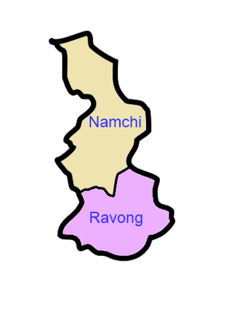
Namchi district is split into two main areas for managing things. These are called sub-divisions.
Administrative Areas


Here are the two sub-divisions:
| Name | Main Town | Number of villages | Location |
| Namchi | Namchi |
 |
|
| Ravong | Ravong |
 |
Villages in the District
- Perbing
Images for kids
-
Mountain view at Ravangla in Namchi district, Sikkim
-
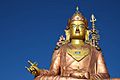
Padmasambhava, the patron saint of Sikkim
-
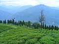
Tea garden
See also
 In Spanish: Distrito de Sikkim meridional para niños
