Nanty Glo, Pennsylvania facts for kids
Quick facts for kids
Nanty Glo, Pennsylvania
|
||
|---|---|---|
|
Borough
|
||

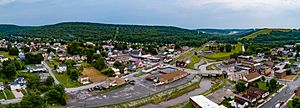
An aerial view of Nanty Glo
|
||
|
||

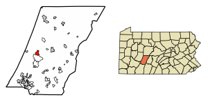
Location of Nanty Glo in Cambria County, Pennsylvania
|
||
| Country | United States | |
| State | Pennsylvania | |
| County | Cambria | |
| Settled | 1890s | |
| Incorporated | 1918 | |
| Government | ||
| • Type | Borough council | |
| Area | ||
| • Total | 1.93 sq mi (5.00 km2) | |
| • Land | 1.93 sq mi (5.00 km2) | |
| • Water | 0.00 sq mi (0.00 km2) | |
| Elevation | 1,709 ft (521 m) | |
| Population
(2020)
|
||
| • Total | 2,511 | |
| • Density | 1,299.69/sq mi (501.75/km2) | |
| Time zone | UTC-5 (Eastern (EST)) | |
| • Summer (DST) | UTC-4 (EDT) | |
| ZIP Code |
15943
|
|
| Area code(s) | 814 | |
| FIPS code | 42-52616 | |
| GNIS feature ID | 1215029 | |
| Website | Nanty Glo,PA | |
Nanty Glo is a small town, called a borough, in Cambria County, Pennsylvania, in the United States. It is part of the larger Johnstown, Pennsylvania area. The town's name comes from the Welsh words Nant y Glo, which mean "stream of coal." This name gives a clue about the town's history. In 2020, about 2,511 people lived here.
Contents
Geography and Location
Nanty Glo is located in the western part of Cambria County. You can find it at coordinates 40°28′20″N 78°50′5″W / 40.47222°N 78.83472°W. The town sits in a valley near the South Branch of Blacklick Creek. This creek flows west and eventually joins the Conemaugh River, which is part of the Ohio River basin.
The county seat, Ebensburg, is about 7 miles (11 km) to the east. The larger city of Johnstown is about 12 miles (19 km) to the southwest. Nanty Glo covers a total area of about 1.9 square miles (4.8 square kilometers). Only a very small part of this area is water.
Population and People
| Historical population | |||
|---|---|---|---|
| Census | Pop. | %± | |
| 1920 | 5,028 | — | |
| 1930 | 5,598 | 11.3% | |
| 1940 | 6,217 | 11.1% | |
| 1950 | 5,425 | −12.7% | |
| 1960 | 4,608 | −15.1% | |
| 1970 | 4,298 | −6.7% | |
| 1980 | 3,936 | −8.4% | |
| 1990 | 3,190 | −19.0% | |
| 2000 | 3,054 | −4.3% | |
| 2010 | 2,734 | −10.5% | |
| 2020 | 2,511 | −8.2% | |
| Sources: | |||
The population of Nanty Glo has changed over the years. In 2010, there were 2,734 people living in the town. This was a decrease from 3,054 people in 2000. About 21% of the people in Nanty Glo were under 18 years old in 2010.
Most residents are White. In 2000, many people in Nanty Glo had family roots from countries like Germany, Italy, Poland, Ireland, and Slovakia. About 29% of households had someone living alone. The average household had about 2.4 people. The median age in Nanty Glo was 42 years old.
Famous People from Nanty Glo
Nanty Glo has been home to several notable people:
- John Brophy, a well-known leader for workers' rights.
- James Anthony "Ripper" Collins, a professional baseball player.
- Charlie Metro, a professional baseball player and manager.
- Boyd David "Buzz" Wagner, the first American flying ace of World War Two.
- Levi Swanson, one of the original founders of the community.
History of Nanty Glo
Nanty Glo started in the 1890s as a place called "Glenglade." By 1896, it was a lumber camp run by Levi Swanson. Houses were built on both sides of the South Branch of Blacklick Creek. This creek forms the border between Blacklick Township and Jackson Township.
A post office opened in Glenglade in 1894. The town's name changed to "Nant-y-glo" in 1901. This change might have been inspired by a town in Wales with the same name. The name "Blacklick" for the creek likely refers to coal found along its banks.
Coal Mining History
By 1899, large amounts of coal were discovered in the area. This brought more settlers to Nanty Glo. The Pennsylvania Railroad even built a special train line to the community that year. Coal mining officially began in 1896. Dr. James W. Dunwiddie opened the first mine, called Nanty Glo No. 1.
In the 1940s, Nanty Glo was known as a "valley coal town." It had four big bituminous coal mines that supported the town. The Heisley Mine, which opened in 1915, was the largest and most successful. It was later sold to Bethlehem Mines and closed in the 1980s. Many other smaller mines also operated in the area.
Schools in Nanty Glo
Formal education started in Nanty Glo around 1898 with a school on the Jackson side of the creek. Later, another school opened on the Blacklick side. Over time, many one-room schoolhouses were built. In 1918, a school district was created. The first high school class graduated in 1925.
Today, Nanty Glo is part of the Blacklick Valley School District. The Blacklick Valley Junior-Senior High School (for grades 7-12) and the Blacklick Valley Elementary Center (for pre-kindergarten to grade 6) are both located in Nanty Glo.
Community Life and Services
The first church in Nanty Glo was the Methodist Episcopal Church, established in 1901. Many other churches were built over the years, including Catholic, Baptist, and Orthodox churches. At one time, Nanty Glo also had several hotels and three movie theaters. One of these theaters, the Liberty, is now being turned into a historical museum.
Besides coal mining, Nanty Glo also had other businesses. These included a chemical factory, a soft drink bottling plant, a plastic factory, and a dress manufacturing company. However, all of these industries and the underground mines have now closed.
Nanty Glo became an official borough in 1918. For much of the 20th century, it was the second-largest town in Cambria County, after Johnstown.
Local Newspaper
The Nanty Glo Journal newspaper started in 1921. It was founded by Herman Sedloff, who wanted to create a newspaper focused on workers' issues. The Journal is still published today.
Fire Department
The Nanty Glo Volunteer Fire Company was formed in 1913. They bought their first hose cart that same year. The fire company is still very active today, with over 100 members. A ladies' group was also started in 1927 to support the fire company.
Public Library
The Nanty Glo Public Library opened in 1980. It has moved several times as it grew. It is now in a large building at 942 Roberts Street.
Historical Society
The Nant-Y-Glo Tri-Area Museum and Historical Society was created in 2000. It works to preserve the history of Nanty Glo and nearby areas. The society is restoring the old Liberty Theater building to display historical items. They also opened the Liberty Cafe, which helps support the Historical Society.
Things to See and Do
Nanty Glo is a great starting point for the Ghost Town Trail. This trail is perfect for biking and walking. It follows old railroad paths through Cambria County and Indiana County. You can find free parking near the trail entrances in the town center.
The Liberty Museum is almost finished. It is located in the former Liberty Theater building at the corner of Shoemaker and Roberts streets.
International Connections
Nanty Glo has a special connection with a town in Wales that shares its name, Nantyglo. They are considered sister towns.
See also
 In Spanish: Nanty Glo para niños


