Ghost Town Trail facts for kids
Quick facts for kids Ghost Town Trail |
|
|---|---|
| Length | 36 mi (58 km) |
| Established | 1991 |
| Designation | |
| Difficulty | Easy |
The Ghost Town Trail is a special path in Western Pennsylvania that used to be a railroad. It stretches for about 36 miles (58 km) between two towns, Black Lick and Ebensburg. This trail was created in 1991 on the old tracks of the Ebensburg and Black Lick Railroad.
As you travel along the trail, it follows the Blacklick Creek. You'll also pass through several ghost towns. These towns were left empty in the early 1900s when the local coal mining industry slowed down. The Ghost Town Trail is open all year for fun activities like cycling, hiking, and even cross-country skiing. It's so special that the United States government has named it a National Recreation Trail.
Contents
Building the Trail
Work on the Ghost Town Trail started in 1991. A company called Kovalchick Salvage Company gave 16 miles (26 km) of the old Ebensburg and Blacklick Railroad to Indiana County. About 12 miles (19 km) of this, between Dilltown and Nanty Glo, became part of the trail.
Later, in 1993, another railroad company, Cambria and Indiana Railroad, donated 4 miles (6.4 km) more. This part connected Rexis, near Vintondale, to White Mill Station. In 2005, the trail grew even more, adding 20 miles (32 km). This extended the trail 12 miles (19 km) west to Black Lick and 8 miles (13 km) east to Ebensburg. In 2016, the trail was made even longer to include the town of Cardiff.
Exploring Historical Sites
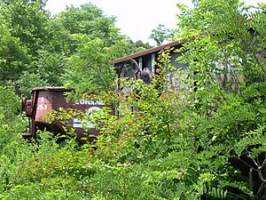
The Ghost Town Trail takes you past many interesting historical spots. You'll see places where old coal mines used to be and where their company towns once stood. These are the "ghost towns" that give the trail its name. Some of these ghost towns include Bracken, Armerford, Lackawanna No. 3, Wehrum, Scott Glenn, Webster, Beulah, and Claghorn.
Wehrum Ghost Town
Wehrum was the biggest of these old towns. It once had 230 houses, a hotel, a company store, a jail, a bank, a post office, a school, and two churches! It was started in 1901 by Warren Delano, who was the uncle of a famous president, Franklin Delano Roosevelt. He built it for a big steel company that opened mines there.
When the mines closed in the 1930s, the town was left empty. Today, only one of the original houses is still standing. You can also see the remains of the bank vault. Another cool leftover from Wehrum is a Russian Orthodox Church cemetery hidden in the woods above the trail. The last people were buried there in 1927. The trail follows the old railroad line that passed by Wehrum, which opened in 1903.
Claghorn Ghost Town
The town of Claghorn began to be built in 1903 by the Lackawanna Coal company. But due to money problems, work stopped in 1904. A different company, Vinton Colliery Company, bought the unfinished town in 1916. They opened six mines nearby.
This company built 84 houses, a big three-story hotel with 22 rooms, a building that was both a school and a theater, and a company store. The old railroad line also went past Claghorn. The mines closed in 1924, and people rented the houses until after World War II. After that, the town was completely abandoned.
Buena Vista Furnace
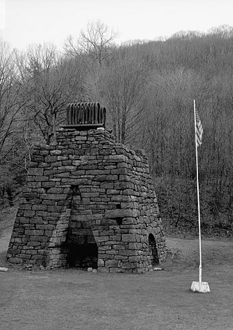
The Buena Vista Furnace was a special kind of blast furnace used to make iron. It was built in 1847 and named after a battle in the Mexican–American War. This furnace was 30 feet tall and used iron ore, limestone, and charcoal found nearby. It could make up to 400 tons of pig iron each year!
The furnace was started by three partners: Henry McClelland, Elias McClelland, and Stephen Johnson. They bought land along the Blacklick Creek. Eventually, their property grew to include a sawmill and houses for more than 60 workers.
By 1850, the furnace was having money problems and had to close. Over the years, it changed owners many times. In 1901, a big steel company bought the property. Later, in 1957, a local history group, the Historical & Genealogical Society of Indiana County, bought it to protect it.
For a long time, it was hard to reach the furnace, and it didn't get many repairs. But when the trail was extended past it in 2005, it became much easier to visit. You can find the furnace along the trail in Brush Valley Township, about half a mile west of PA 56.
Eliza Furnace
|
Eliza Furnace
|
|

Front of Eliza Furnace
|
|
| Location | Vintondale, Pennsylvania |
|---|---|
| Built | 1846 |
| NRHP reference No. | 91001138 |
| Significant dates | |
| Added to NRHP | September 6, 1991 |
| Designated | Structure |
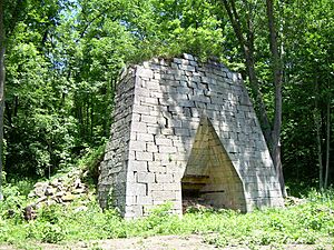
The Eliza Furnace, also known as Ritter's Furnace, made iron between 1846 and 1849. It's one of the best-preserved old iron furnaces in Pennsylvania. It was also one of the first in the area to use a special "hot blast" method. Today, it's listed on the National Register of Historic Places. When it was busiest, the furnace made about 1,080 tons of iron each year. It employed over 90 men and boys, and even used 45 mules!
In the 1830s and 1840s, two partners, David Ritter and George Rodgers, bought a lot of land in the Blacklick Valley. They started building the furnace in 1845. The iron made at Eliza was taken by wagon to other towns like Nineveh (now Seward) or Johnstown. From there, it was shipped on the Pennsylvania Canal to Pittsburgh.
The furnace operation included many buildings like a casting house, twenty-one log homes, a wagon shop, and a store. Workers were often paid with goods instead of money. The furnace never made a profit and had to close for several reasons. The main railroad line didn't come through the Blacklick Valley, the furnace used old technology, and it cost too much to haul the iron to the canal.
The Eliza Furnace is located in Vintondale, which is about halfway along the trail. At the site, you'll also find a picnic area, restrooms, and signs that tell you more about its history.
Trail Access Points
You can get onto the Ghost Town Trail at several different spots. Each access point has a location, mileage marker, and elevation.
| Access | Location | Mileage | Elevation |
|---|---|---|---|
| Saylor Park Black Lick |
1-mile (1.6 km) from U.S. Route 119 |
0 miles (0 km) | 980 feet (300 m) |
| Heshbon | PA Route 259 | 6.5 miles (10.5 km) | 1,260 feet (380 m) |
| Dilltown | PA Route 403 | 13 miles (21 km) | 1,350 feet (410 m) |
| Wehrum | Vintondale Rd. | 16 miles (26 km) | 1,355 feet (413 m) |
| Vintondale Eliza Furnace |
Vintondale Rd. | 19 miles (31 km) | 1,360 feet (410 m) |
| Twin Rocks | PA Route 271 | 22 miles (35 km) | 1,660 feet (510 m) |
| Nanty Glo | PA Route 271 | 25 miles (40 km) | 1,720 feet (520 m) |
| Ebensburg | U.S. Route 422 | 33 miles (53 km) | 2,000 feet (610 m) |
 | May Edward Chinn |
 | Rebecca Cole |
 | Alexa Canady |
 | Dorothy Lavinia Brown |


