
Napranum, Queensland facts for kids
Quick facts for kids NapranumQueensland |
|
|---|---|

Napranum seen from Weipa
|
|

Napranum
Location in Queensland
|
|
| Population | 716 (2021 census) |
| Postcode(s) | 4874 |
| Time zone | AEST (UTC+10:00) |
| Location | |
| LGA(s) | Aboriginal Shire of Napranum |
| State electorate(s) | Cook |
| Federal Division(s) | Leichhardt |
Napranum is a remote town in the locality of Mission River in the Aboriginal Shire of Napranum, Queensland, Australia. It's located on the western coast of the Cape York Peninsula. In 2021, the town of Napranum had a population of 716 Indigenous Australians.
Contents
What's in a Name? The Meaning of Napranum
The name Napranum is a special word. It combines two words from local Aboriginal languages. "Nap" comes from the Trotj language and means "meeting place." "Pranum" comes from the Thaynakwith language and means "meeting of people." So, together, Napranum means "meeting place of the people."
Where is Napranum Located?
Napranum is found on the western coast of the Cape York Peninsula in a very remote part of Far North Queensland. It is right next to the town of Weipa. The town is about 600 kilometers (370 miles) northwest of Cairns if you travel in a straight line. By road, the distance is about 819 kilometers (509 miles).
A Look Back: The History of Napranum
The Alngith people are believed to be the original traditional owners of the land where Napranum is today. Other Aboriginal groups, like the Anathangayth, Peppan, Thanakwithi, Wathyn, and Wik Waya peoples, also lived in this area.
Early Mission Days
Napranum was once known as Weipa South. It was started in 1898 by missionaries from the Moravian Church and the Presbyterian church. The mission was set up inland to keep people safe from lugger boats. These boats were known for taking Aboriginal people to work in diving operations.
A school was opened at the mission in 1900.
Changes in Control
In 1911, new laws were made in Queensland. These laws gave a person called the "Chief Protector of Aborigines" a lot of power. This person could decide where Aboriginal children lived until they were 21. They could also decide where Aboriginal people lived and move them between different areas. This was done to "protect" them, but it also meant they had less freedom.
In 1932, the community had to move to its current location at Jessica Point. This move happened because of malaria, a serious disease spread by mosquitoes. Over time, people from other Aboriginal communities, like Old Mapoon, were also brought to Napranum.
Discovering Bauxite
In 1955, a geologist named Henry Evans made an important discovery. He found huge amounts of bauxite in the red cliffs near the Aboriginal reserve. Bauxite is the main rock used to make aluminium. This discovery led to big changes for the area.
Schooling and Land Changes
In 1964, the Queensland Education Department took over running the school from the Mission Board. The school changed names several times, eventually becoming the Jessica Point State School. Later, in 2002, it became part of the Western Cape College. However, this campus closed in 2005, and students moved to the Weipa Campus.
In 1957, a law called the Comalco Act was passed. This law removed the special status of the Aboriginal reserve land. It gave a mining company, Comalco, a large amount of land for mining bauxite. Mining started in 1960. The mission became a government settlement in 1966. Comalco also built a new town for its workers on the other side of the bay.
Eventually, Napranum gained its own community council. This meant the community had more control over its own affairs.
Population of Napranum
The number of people living in Napranum has changed over the years.
- In 2006, there were 830 people, with 778 (93.7%) being Indigenous Australians.
- By 2016, the population grew to 950 people, with 907 (95.45%) being Indigenous Australians.
- In the most recent census in 2021, the town had a population of 716 Indigenous Australians.
Learning in Napranum
There are no schools directly in Napranum. Students usually attend the nearest government primary and secondary school. This school is the Weipa campus of Western Cape College, located in Rocky Point to the north.
Community Places in Napranum
Napranum has some important community places:
- A Police Citizens Youth Club (PCYC) opened in 2019 on Napranum Road. This club offers activities and support for young people.
- The Mary Ann Coconut Library is an Indigenous Knowledge Centre (IKC). It's named after a respected elder. The library was first opened in 2015 and later moved to the Susie Madua Hall in 2021. It's a place for learning and community gatherings.
Inspiring People: Aunty Mary Ann Coconut
Aunty Mary Ann Coconut is a very important and respected elder from Napranum. She was born in 1943. Her language name is Amomanja, which means 'sugar glider'.
- Early Life and Education: From a young age, she lived at the Weipa Mission School. She was very good at art and even won an award in 1952. She became a teacher aide in 1957. Later, in 2009, she earned a university degree in Community Management.
- Community Leadership: Aunty Mary Ann served many terms as an elected councillor, helping to lead her community. She also worked with other elders to start the first women's shelter in the area.
- Protecting Nature: In the 1980s, she was a key member of a committee that helped create the Uningan Nature Reserve. This reserve protects 2000 hectares (about 4940 acres) of land. She also helped establish the Bicentennial Community Park.
- Recognized Elder: She is featured in the 'Elders Hall of Fame' for her contributions to the Western Cape Communities Co-Existence Agreement.
- Preserving Language: Along with her cousin and other family members, she helped create a dictionary of the Thanikwithi language. This dictionary was published in 2007, helping to keep the language alive.
Images for kids
-
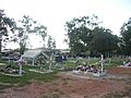
The Napranum community cemetery.
-
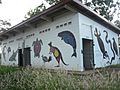
Local artwork on community sports ground building.
-
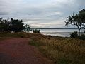
Looking towards the Embley River from the township. A great spot for fishing and boating.


