
National Register of Historic Places listings in Carbon County, Montana facts for kids

Have you ever wondered about the oldest and most special places in your community? In Carbon County, Montana, there's a list of amazing historic spots! This list is called the National Register of Historic Places. It's like a hall of fame for buildings, areas, and even old trails that are super important to American history.
These places are chosen because they tell a story about the past. They might be old homes, schools, bridges, or even places where important events happened. When a place is on this list, it means it's recognized nationally for its historical value. It also helps protect these places for future generations, like you, to learn from and enjoy.
In Carbon County, Montana, there are 65 different properties and historic districts on this special list. Let's explore some of them!
Contents
What is the National Register of Historic Places?
The National Register of Historic Places is the official list of the nation's historic places. It's part of a program by the United States government. This program helps to find and protect historic and archaeological sites across the country. Being on the Register means a place is important for its history, architecture, or even its archaeology.
Why are places listed?
Places get listed for many reasons. Maybe a famous person lived there. Perhaps it's a great example of an old building style. Or it could be a site where ancient people lived. The goal is to keep these places safe so we can always remember and learn from our past.
Historic Places in Carbon County
Carbon County has many interesting places on the National Register. These sites show the rich history of the area. From old trails to unique buildings, each one has a story to tell.
Ancient Trails and Sites
Some of the oldest listings in Carbon County are not buildings at all! They are ancient trails and archaeological sites. These places give us clues about how people lived long ago.
Bad Pass Trail
The Bad Pass Trail is an ancient pathway. It runs along the Bighorn River near Warren, Montana. This trail was used by Native Americans for thousands of years. It's a reminder of the early people who traveled through this land.

Petroglyph Canyon
Imagine finding ancient rock art! Petroglyph Canyon near Warren, Montana is one such place. It has carvings on rocks made by early inhabitants. These carvings, called petroglyphs, are like messages from the past. They show us what was important to these ancient cultures.
Pretty Creek Archeological Site
The Pretty Creek Archeological Site is another important ancient location. It helps scientists understand how people lived in this region a very long time ago. These sites are often kept secret to protect them.
Historic Buildings and Districts
Many listings are historic buildings or groups of buildings called "historic districts." These show us how towns grew and how people lived in more recent times.
Fromberg's Historic Buildings
The town of Fromberg, Montana has several buildings on the list. These include the old Fromberg Opera House, where people once watched shows. There's also the Fromberg Concrete Arch Bridge. This bridge crosses the Yellowstone River and is a cool example of old engineering.

Red Lodge's Commercial District
Red Lodge, Montana has a special area called the Red Lodge Commercial Historic District. This district includes many old shops and buildings downtown. Walking through it is like stepping back in time. You can see how the town looked when it was first growing.

Bearcreek Bank
The Bearcreek Bank in Bearcreek, Montana is another interesting building. It shows the kind of architecture popular in the early 1900s. It reminds us of the town's past as a mining community.

Churches and Homes
Many historic churches and homes are also listed. The Calvary Episcopal Church in Red Lodge is one example. These buildings show the community's faith and how families lived.

Joliet's Historic Spots
The town of Joliet, Montana also has several listed places. These include the old Joliet High School and the Joliet Bridge. There's even a Joliet Residential Historic District. This area has many old homes that show how people lived in Joliet's early days.
Ranches and Farms
Montana is known for its wide-open spaces and ranches. Some historic ranches are also on the list.
Caroline Lockhart Ranch
The Caroline Lockhart Ranch is one such place. Caroline Lockhart was a famous writer and journalist. Her ranch tells a story about life in the American West.

Kero Farmstead Historic District
Near Roberts, Montana, you can find the Kero Farmstead Historic District. This district shows what a working farm looked like long ago. It helps us understand the farming history of Carbon County.
Industrial and Mining History
Carbon County has a strong history of mining. Some listings reflect this important past.
Smith Mine Historic District
The Smith Mine Historic District near Bearcreek, Montana is a very important site. It reminds us of the coal mining industry that shaped the area. It also honors the miners who worked there.

Red Lodge Brewing Company
The Red Lodge Brewing Company-Red Lodge Canning Company building is another industrial site. It shows how local businesses operated in the past. It tells a story of local production and commerce.

Roads and Infrastructure
Even roads can be historic!
Red Lodge-Cooke City Approach Road Historic District
The Beartooth Highway, also known as the Red Lodge-Cooke City Approach Road Historic District, is a famous scenic road. It's listed because of its amazing engineering and beautiful views. This road is a true marvel!

Images for kids
-
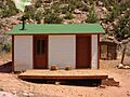
Hulbert's Cabin at Cedarvale
-
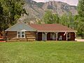
The Ewing-Snell Ranch House
-
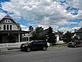
A building in the Hi Bug Historic District


