
National Register of Historic Places listings in Carroll County, Maryland facts for kids

This page is about the amazing historic places in Carroll County, Maryland, that are listed on something called the National Register of Historic Places. Think of it as a special list of buildings, farms, and areas that are super important to American history and culture.
These places are officially recognized by the United States government because they tell a story about the past. They could be old homes, schools, churches, or even entire neighborhoods! When a place is on this list, it means it's worth protecting and remembering for future generations.
In Carroll County, there are 62 different places and areas on this special list. One of them is even a National Historic Landmark, which is an even higher level of importance! You can see where many of these places are located on a map using their latitude and longitude coordinates.
Contents
What is the National Register of Historic Places?
The National Register of Historic Places is like a big honor roll for historic sites across the United States. It's managed by the National Park Service, which is part of the U.S. government.
Why are places added to the list?
Places get added to this list for many reasons. Maybe they are:
- Very old and show how people lived a long time ago.
- Designed in a special way that shows important architecture.
- Connected to important events in history.
- Linked to famous people who made a difference.
Being on the National Register helps protect these places. It also helps people learn about their history and why they are important.
Some Historic Places in Carroll County
Carroll County has many interesting places on the National Register. Here are a few examples:
Historic Homes and Farms
Many of the listings in Carroll County are old homes and farms. These places often show how people lived and worked in the past.
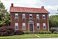
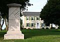
- Antrim (Taneytown): This beautiful old mansion and its gardens are located south of Taneytown. It was added to the list in 1977.
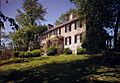
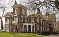
- Branton Manor (Sykesville): Found on Old Liberty Road in Sykesville, this manor was recognized in 1978.
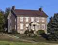
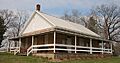
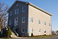
- Moses Brown House (Eldersburg): This historic house is southeast of Eldersburg on Ridge Road and was listed in 1980.
- Christopher Erb House (Silver Run): Located on Flickinger Road in Silver Run, this house became a historic listing in 1985.
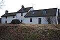
- Hard Lodging (Union Bridge): This interesting place on Ladiesburg Road in Union Bridge was added to the list in 1978.
- Hopewell (Union Bridge): Another historic spot near Union Bridge, found at Pearre and Clemsonville Roads, listed in 1980.
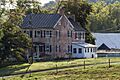
- Jacob Koons Farm (Taneytown): This farm near Taneytown was added to the list in 2011.
- Mt. Pleasant (Union Bridge): Located on West Locust Street in Union Bridge, this site was recognized in 1998.
- Terra Rubra (Keysville): This historic place on Keysville Bruceville Road in Keysville was listed in 1978.
- Trevanion (Uniontown): Found on Trevanion Road in Uniontown, this site was added in 1977.
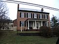
- Ludwick Rudisel Tannery House (Taneytown): This house on Frederick Street in Taneytown was listed in 1980. It might have been part of a tannery, where animal hides were turned into leather.
Historic Districts
Sometimes, it's not just one building that's historic, but a whole area or neighborhood! These are called historic districts.
- Lineboro Historic District: This district includes Main Street, Church Street, and Mill Street in Lineboro. It was recognized in 1996.
- Linwood Historic District: Located on McKinstry's Mill Road in Linwood, this district was added in 1980.
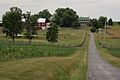
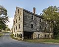
- McKinstry's Mills Historic District: This district near Union Bridge includes several roads and was listed in 1997.
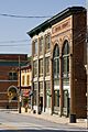
- Mount Airy Historic District: This district in Mount Airy includes several streets like Main, Church, and Maple. It was recognized in 1984.
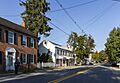
- New Windsor Historic District: This area in New Windsor is bounded by several avenues and roads, and was listed in 1997.
- Sykesville Historic District: This district in Sykesville includes Main Street and several avenues. It was added in 1985.
- Taneytown Historic District: This district in Taneytown includes parts of Maryland Routes 140 and 194. It was recognized in 1986.
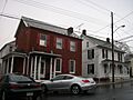
- Union Bridge Historic District: This district in Union Bridge includes streets like Bellevue and Locust, and parts of the Western Maryland Railway tracks. It was listed in 1994.
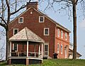
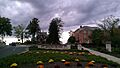
- Union Mills Homestead Historic District: This important district is at the junction of U.S. Route 140 and Deep Run Road near Westminster. It was one of the earliest listings in 1971.
- Uniontown Historic District: This district in Uniontown includes Uniontown and Trevanion Roads. It was added in 1986.
- Western Maryland College Historic District: This district in Westminster includes parts of West Main and College Streets. It was recognized in 1976.
- Westminster Historic District: This large district in Westminster includes parts of Maryland Routes 32 and 97. It was listed in 1980.
Other Notable Sites
Carroll County also has other unique historic places.
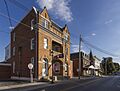
- Hampstead School (Hampstead): This old school building on North Main Street in Hampstead was added to the list in 2002.
- Old National Pike Milestones (Mount Airy): These are old markers along the historic U.S. Route 40 near Mount Airy. They were listed in 1975. Milestones helped travelers know how far they had gone!
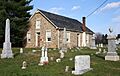
- Pipe Creek Friends Meetinghouse (Union Bridge): This historic meetinghouse on Quaker Hill Road in Union Bridge was recognized in 1976. Meetinghouses are places of worship for Quakers.
- Springfield Presbyterian Church (Sykesville): This church on Spout Hill Road in Sykesville was added to the list in 1986.
- Union Bridge Station (Union Bridge): This old train station on North Main Street in Union Bridge was listed in 1976. It was once operated by the Western Maryland Railway.
- Uniontown Academy (Uniontown): This historic academy building on Uniontown Road in Uniontown was recognized in 1973. Academies were early schools.
- Warfield Complex, Hubner, and T Buildings (Sykesville): These buildings are part of the Springfield Hospital Center in Sykesville and were listed in 2000.
Images for kids
-
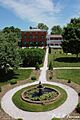
Antrim mansion and garden
-
Branton Manor
-

Moses Brown House
-

Christopher Erb House
-
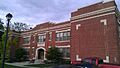
Hampstead School
-
Hard Lodging
-
Hopewell
-
Jacob Koons Farm
-
Franz Farm in the Linwood Historic District
-
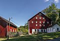
McKinstry's Mill
-
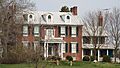
McMurray-Frizzell-Aldridge Farm
-
Downtown Mount Airy
-
Mt. Pleasant in Union Bridge
-
New Windsor, Maryland
-
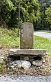
Old National Pike Milestone
-
Pipe Creek Friends Meetinghouse
-

Roop's Mill
-
Ludwick Rudisel Tannery House
-
Slagle-Byers House
-
Springfield Presbyterian Church
-
Stoner-Saum Farm
-
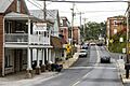
Downtown Sykesville
-
Taneytown Historic District
-
Terra Rubra
-
Trevanion
-
Union Bridge Historic District
-
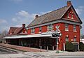
Union Bridge Station
-

Union Mills Homestead Historic District
-
Uniontown Historic District
-

Warfield Complex, Springfield Hospital
-
Wesley Chapel Methodist Episcopal Church
-
Western Maryland College Historic District
-
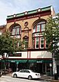
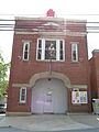
Babylon Building in Westminster
.jpg)


.jpg)


.jpg)


