
National Register of Historic Places listings in Gila County, Arizona facts for kids

Welcome to Gila County, Arizona! This special place is home to many historic sites. These sites are listed on the National Register of Historic Places. This is a list of places in the United States that are important to history. They are worth protecting for future generations.
Gila County has 53 places on this important list. One of them is even a National Historic Landmark. This means it's super important to the whole country! Let's explore some of these amazing historic spots.
Contents
- Ancient Wonders
- Important Buildings and Structures
- Coolidge Dam
- Bullion Plaza School
- Gila County Courthouse
- Gila Valley Bank and Trust Building
- Globe Mine Rescue Station
- Holy Angels Church
- International House
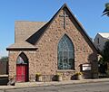
- Miami Community Church
- Our Lady of the Blessed Sacrament Church
- Pryor Miller House
- Natural Bridge Lodge
- Ox Bow Inn
- Pinal Ranger Station
- Pleasant Valley Ranger Station
- Alfred Jason Randall House
- St. John's Episcopal Church
- La Santa Cruz de Globe
- Soderman Building
- Strawberry Schoolhouse
- Theodore Roosevelt Dam National Register District
- US Post Office and Courthouse-Globe Main
- Historic Districts and Other Sites
- Images for kids
Ancient Wonders
Some of Gila County's most fascinating places are very old. They tell us about people who lived here long, long ago.
Besh-Ba-Gowah

Imagine living in a village built from stone! That's what you'll find at Besh-Ba-Gowah. This ancient village is south of Globe. It was built by the Salado people around 1225 AD. You can walk through the ruins and see how people lived. It's like stepping back in time!
Kinishba Ruins

The Kinishba Ruins are a true national treasure. They are so important that they are a National Historic Landmark. These ruins are a large ancient pueblo. A pueblo is a type of village built by Native Americans. The Kinishba Ruins are near Whiteriver. They show us how people lived and built homes centuries ago.
Gila Pueblo Archaeological Foundation

South of Globe, you'll find Gila Pueblo. This place was once a center for studying ancient cultures. It helped us learn a lot about the people who lived in this area. It's a key spot for understanding Arizona's past.
Houston Mesa Ruins
The Houston Mesa Ruins are near Payson. These ruins give us clues about prehistoric life. They show us how early people built and lived in this part of Arizona.
Tonto National Monument Archeological District

The Tonto National Monument Archeological District is a large area. It's near Roosevelt. This district protects many ancient sites. These sites include the Lower and Upper Ruins. They are cliff dwellings built by the Salado people. You can see their homes tucked into the cliffs.
Tonto National Monument Visitor Center

Before exploring the ruins, stop at the Tonto National Monument Visitor Center. It's located on Arizona State Highway 188. Here, you can learn about the Salado people. You can also find out about the monument's history.
Tonto National Monument, Lower Ruin

The Lower Ruin is a well-preserved cliff dwelling. It's part of the Tonto National Monument. You can hike to this ruin and see the ancient rooms. It's an amazing example of early architecture.
Tonto National Monument, Upper Ruin
The Upper Ruin is another impressive cliff dwelling. It's also part of the Tonto National Monument. This ruin is higher up. It offers a different view of how the Salado people lived.
Important Buildings and Structures
Gila County also has many historic buildings and structures. These show us how people lived and worked more recently.
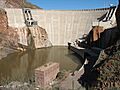
Coolidge Dam

The Coolidge Dam is a huge structure southwest of San Carlos. It was built to control water and provide power. It's an amazing example of early 20th-century engineering. The dam is still an important part of the area today.
Bullion Plaza School

The Bullion Plaza School in Miami is a historic building. It was once a school for many children. Today, it has a new life as the Bullion Plaza Museum. It teaches visitors about the history of the area.
Gila County Courthouse

The Gila County Courthouse is in Globe. It's a beautiful old building. It has been a center for local government for many years. It stands as a symbol of justice and community.
Gila Valley Bank and Trust Building

Also in Globe is the Gila Valley Bank and Trust Building. This building was once a busy bank. It played a big role in the town's economy. It shows us what banks looked like long ago.
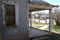
Globe Mine Rescue Station

The Globe Mine Rescue Station was very important for miners. It helped keep them safe. Today, this building is the Gila County Historical Museum. It tells the story of mining and life in Gila County.
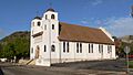
Holy Angels Church

Holy Angels Church is a beautiful church in Globe. It has been a place of worship for many years. Its architecture and history make it a special landmark.
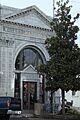
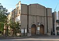
International House
_from_E_1.JPG)
The International House in Globe is another historic building. It shows the unique style of buildings from its time. It adds to the rich history of Globe's downtown area.
Miami Community Church
_from_N_1.JPG)
The Miami Community Church is an important part of the Miami community. It has served as a gathering place for many years. Its history reflects the spirit of the town.
Our Lady of the Blessed Sacrament Church
_from_E_2.JPG)
In Miami, you can also find Our Lady of the Blessed Sacrament Church. This church is known for its beautiful design. It is a significant religious landmark in the area.
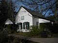
Pryor Miller House

The Pryor Miller House is located on State Route 87 in Pine. This house is a great example of historic homes in the region. It tells a story about the families who lived there.
Natural Bridge Lodge

The Natural Bridge Lodge is off State Route 87 near Payson. This lodge is close to the famous Tonto Natural Bridge. It has welcomed visitors for many years.
Ox Bow Inn

The Ox Bow Inn in Payson is a rustic and charming place. Its design was inspired by the famous Old Faithful Inn in Yellowstone. It's a unique spot with a lot of character.
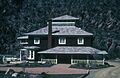
Pinal Ranger Station

The Pinal Ranger Station is south of Globe in the Tonto National Forest. Ranger stations were vital for managing forests. This one shows the history of forest service in Arizona.
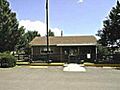
Pleasant Valley Ranger Station

Another historic ranger station is the Pleasant Valley Ranger Station. It's south of State Route 288 in the Tonto National Forest. These stations helped protect our natural lands.
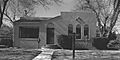
Alfred Jason Randall House

The Alfred Jason Randall House is on State Route 87 in Pine. This house is part of the area's history. It shows the style of homes built by early settlers.
St. John's Episcopal Church
_from_SE_2.JPG)
St. John's Episcopal Church in Globe is a beautiful historic church. It has served the community for many years. Its architecture is a notable part of Globe's landscape.
La Santa Cruz de Globe
_from_S_1.JPG)
La Santa Cruz de Globe is a cross located on a hilltop in Ruiz Canyon. It's a significant cultural and religious landmark for the community of Globe.
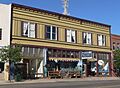
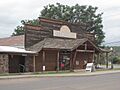
Soderman Building
_from_N_1.JPG)
The Soderman Building in Miami is a historic commercial building. It shows the kind of businesses that thrived in the town's past.
Strawberry Schoolhouse

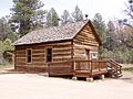
The Strawberry Schoolhouse is near Strawberry. It's a charming old school building. It reminds us of how children learned in the past. It's a great example of a one-room schoolhouse.
Theodore Roosevelt Dam National Register District

The Theodore Roosevelt Dam National Register District is a special area. It's along the shore of Lake Roosevelt. This district includes buildings and structures that helped build the famous Theodore Roosevelt Dam. The dam itself is a marvel of engineering.
US Post Office and Courthouse-Globe Main

The US Post Office and Courthouse-Globe Main is a grand building in Globe. It has served as a post office and courthouse. It's a key part of the city's civic history.
Historic Districts and Other Sites
Some historic listings cover entire areas, not just single buildings. These are called historic districts.
Globe Downtown Historic District

The Globe Downtown Historic District includes many old buildings in Globe. It covers Broad Street between Cedar and Tebbs. Walking through this district is like taking a trip back in time. You can see the historic architecture and feel the old-town charm.
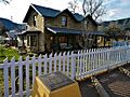
Pine Community Center Historic District

The Pine Community Center Historic District is in Pine. This area includes several historic buildings. They show the development of the community. It's a great place to see how the town grew.
Thompson Draw Summer Homes Unit 1 Historic District
Near Payson, you'll find the Thompson Draw Summer Homes Unit 1 Historic District. This district includes a collection of historic summer homes. These homes were built for people to enjoy the cooler mountain air. They show how people used to vacation.
Images for kids
-
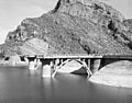
The impressive Coolidge Dam.
-
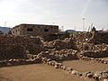
The Gila Pueblo, once a center for studying ancient cultures.
-
The historic Gila County Courthouse in Globe.
-
The Gila Valley Bank and Trust Building.
-
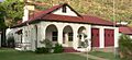
The Globe Mine Rescue Station, now a museum.
-
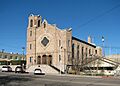
Holy Angels Church in Globe.
-
The International House in Globe.
-
The Miami Community Church.
-
Our Lady of the Blessed Sacrament Church in Miami.
-
The historic Pryor Miller House.
-
The Natural Bridge Lodge near Payson.
-
The rustic Ox Bow Inn in Payson.
-
The Pinal Ranger Station.
-
A historic home within the Pine Community Center Historic District.
-
The Pleasant Valley Ranger Station.
-
The Alfred Jason Randall House.
-
St. John's Episcopal Church in Globe.
-
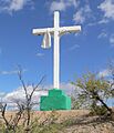
La Santa Cruz de Globe, a cross on a hilltop.
-

The Soderman Building in Miami.
-
The historic Strawberry Schoolhouse.
-
The impressive Theodore Roosevelt Dam.
-
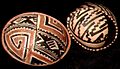
Ancient Salado pottery found at Tonto National Monument.
-
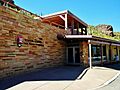
The Visitor Center at Tonto National Monument.
-
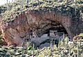
The Lower Ruin at Tonto National Monument.
-
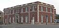
The US Post Office and Courthouse in Globe.
