
National Register of Historic Places listings in Gogebic County, Michigan facts for kids

Have you ever wondered about the oldest and most special buildings or places in your community? In Gogebic County, Michigan, there are 11 amazing spots that are so important, they're listed on the National Register of Historic Places. This is a special list kept by the United States government. It helps protect places that tell us about history, art, or how people lived long ago.
These places are like treasures that show us what life was like in Gogebic County, especially when mining was a huge part of the area. Let's explore some of these cool historic sites!
Historic Places in Gogebic County
Chicago and Northwestern Railroad Depot

This old train station in Ironwood was built way back in 1892. It was first used by a company called the Milwaukee, Lake Shore and Western Railroad. Later, it became part of the famous Chicago and North Western Railway.
Imagine a time when trains were the main way to travel! This station had a long platform, almost a whole city block, where people would get on and off trains. It was used for passengers until 1970 and for carrying goods until 1971. Today, this beautiful red brick and sandstone building is home to the Ironwood Area Historical Society, which helps keep local history alive.
Copper Peak

Get ready for an exciting fact! Copper Peak, located near Ironwood, is super unique. It's the only ski flying hill in the entire Western Hemisphere! Ski flying is like ski jumping, but on a much bigger scale, allowing skiers to fly incredible distances.
This huge structure was built in 1969. It hosted amazing ski flying competitions between 1970 and 1994, bringing athletes from all over the world to Gogebic County. It's a true landmark for sports history!
Solomon S. Curry House

The Solomon S. Curry House in Ironwood is a beautiful old home built for a very important person. Solomon S. Curry was the president of a company that started a lot of mining in the Gogebic Range in the early 1880s. The discovery of iron ore here led to the creation of Ironwood itself, and Curry was one of the city's founders.
After a big fire in 1887, Mr. Curry built this house for his family. It's designed in a style called Queen Anne architecture, which means it has lots of decorative details, different textures, and often a tower or turret. It shows how successful the mining industry made the area back then.
Gogebic County Courthouse

The Gogebic County Courthouse in Bessemer is a grand building with a lot of history. Gogebic County was formed in 1887, separating from Ontonagon County. Right away, the new county decided to build a courthouse.
This rectangular building, made of red sandstone, was finished in 1888. It cost $50,000, which was a huge amount of money back then! The courthouse was designed in the Romanesque Revival style, which uses round arches and sturdy stone, making it look strong and important. It shows how excited and hopeful people were when Gogebic County was new and the mining industry was booming.
Ironwood Carnegie Library

The Ironwood Carnegie Library is a special place for books and learning. It was built in 1901 with a $17,000 grant from Andrew Carnegie. Andrew Carnegie was a very rich businessman who believed in the power of education. He funded the building of thousands of libraries across the United States.
This library was actually the first Carnegie Library ever built in Michigan! It's amazing to think that it's still open and helping people learn and read today, more than 120 years later.
Ironwood Theatre Complex

The Ironwood Theatre is a true gem for entertainment and culture. It first opened its doors in 1928. Back then, it showed the newest movies and also hosted vaudeville shows. Vaudeville was a popular type of entertainment with different acts like singers, dancers, comedians, and magicians.
The theatre continued to show movies until 1982. But don't worry, it didn't stay closed! In 1988, it reopened as a non-profit organization. Now, it offers all sorts of shows and events for the community. Inside, you can find a beautifully restored Barton Organ. This type of organ was used to play music during silent movies or as part of vaudeville shows. There are only four of these organs left in playable condition, making the Ironwood Theatre even more unique!
Main Street – Black River Bridge

The Main Street – Black River Bridge in Bessemer Township is an important part of the area's transportation history. It was built in 1923 to replace an older bridge that was causing traffic jams in the village of Ramsay.
This bridge is a concrete through girder bridge. This design was very common in Michigan between 1913 and 1930, with hundreds built across the state. What makes this bridge special is its unique triple-span design and its tapered concrete piers, which are the supports holding it up. It's a great example of how engineers designed bridges to handle growing traffic almost a century ago.
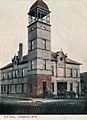
Ironwood Memorial/Municipal Building

The Ironwood Memorial Building is a two-story building in Ironwood that serves many purposes. It was built in the Neoclassical style, which means it looks like ancient Greek or Roman buildings with grand columns and balanced designs.
This building was created to be the city's main office building and also a place for people to gather and have fun. But it's more than just a city hall. It's also a memorial to the brave men from the area who served in the Civil War, the Spanish–American War, and World War I. Inside, you can find beautiful murals, statues, and stained glass windows that honor these veterans. It's a place where history and community come together.
Planter Road – Jackson Creek Bridge

The Planter Road – Jackson Creek Bridge, located in Wakefield Township, is a type of bridge called a steel plate girder bridge. This kind of bridge uses large steel plates to form strong beams that support the road.
While this type of bridge was common in states like Pennsylvania and New York, it's actually quite rare to find one in Michigan. This makes the Planter Road – Jackson Creek Bridge a special example of bridge engineering in the state.
Rice Bay
Rice Bay, found in Watersmeet Township, is a very important natural area. It's located on the Michigan side of Lac Vieux Desert, a large lake. What makes Rice Bay special is its significant stand of wild rice.
This wild rice has been traditionally managed and harvested by the Lac Vieux Desert Band of Lake Superior Chippewa Indians for a very long time. It's not just a plant; it's a vital part of their culture, food, and traditions. This site helps protect both the natural environment and the cultural heritage of the area.
Images for kids
-
The Ironwood City Hall, built in 1890, was demolished in 1989.

