
National Register of Historic Places listings in Jackson County, Missouri facts for kids

Welcome to Jackson County, Missouri! This area is home to many important places listed on the National Register of Historic Places. This special list helps protect buildings, sites, and objects that are important to American history.
Jackson County has 387 places on this list. This includes 4 National Historic Landmarks and 1 National Historic Site. Most of these, about 336, are in Kansas City. Those are listed separately. This article will tell you about 51 other amazing historic places found outside Kansas City.
Contents
Exploring Historic Places in Jackson County
Jackson County is full of history! Let's discover some of the cool places that are protected here. These sites tell stories about how people lived, worked, and shaped the area over many years.
Fort Osage: A Frontier Adventure
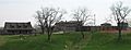
One of the most exciting places is Fort Osage. It's located near Sibley on the Missouri River. This fort was built in 1808 by William Clark (yes, from the Lewis and Clark expedition!). It was an important trading post and military fort on the edge of the American frontier.
Fort Osage helped control trade with Native American tribes. It also protected American settlers moving west. Today, you can visit a rebuilt version of the fort. It looks much like it did over 200 years ago. It's a great place to learn about early American history and frontier life. The area around the fort is also an important archeological district. This means scientists have found many old artifacts there.
Homes with History
Many historic homes in Jackson County are on the National Register. These houses show us different styles of architecture and how families lived long ago.
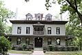
Bingham-Waggoner House
The Bingham-Waggoner House and Estate is in Independence. It was built in 1852. This grand home belonged to George Caleb Bingham, a famous Missouri artist. Later, it was owned by the Waggoner family. Visiting this house is like stepping back in time to the 1800s.
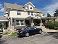
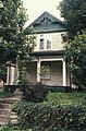
Dr. John S. Jr. and Harriet Smart Bryant House
Also in Independence is the Dr. John S. Jr. and Harriet Smart Bryant House. This house was built in 1890. It shows the style of homes from that time.
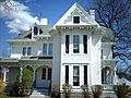
Mollie and Josephine Hughes House
The Mollie and Josephine Hughes House is another historic home in Independence. It was built in 1890. It tells a story about the people who lived there.
Kritser House
The Kritser House in Independence was built in 1878. It is a well-preserved example of homes from the late 1800s.
Lewis-Webb House
The Lewis-Webb House in Independence dates back to 1850. It is one of the older homes on the list.
Charles Minor House
The Charles Minor House was built in 1855 in Independence. It offers another look at the architecture of the mid-19th century.
Owens-McCoy House
The Owens-McCoy House in Independence was built in 1885. It is a beautiful example of a Victorian-era home.
Rice-Tremonti House
In Raytown, you can find the Rice-Tremonti House. This house was built around 1844. It is one of the oldest homes in the county. It shows us what early farmhouses looked like.
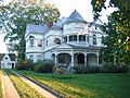
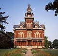
Vaile Mansion
The Vaile Mansion is a very impressive home in Independence. It was built in 1881. This mansion has many unique features, like 10 fireplaces and a huge tower. It's known for its beautiful Victorian architecture.
Woodson-Sawyer House
The Woodson-Sawyer House in Independence was built in 1855. It is another historic home that helps us understand the past.
Important Public Buildings
Jackson County also has historic public buildings. These places were important for the community and government.
Jackson County Courthouse
The Jackson County Courthouse in Independence was built in 1933. It is a grand building where important decisions were made. It's a key part of the city's history.
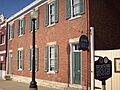
Jackson County Jail and Marshal's House
The Jackson County Jail and Marshal's House in Independence was built in 1859. This old jail gives us a glimpse into the justice system of the past. It also includes the marshal's home.
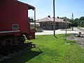
Missouri Pacific Depot
The Missouri Pacific Depot in Independence was built in 1913. This old train station was a busy place. It connected Independence to other cities by rail.
Religious and Community Sites
Some places on the list are important for religious or community history.
Lee's Summit Christian Church Building
The Lee's Summit Christian Church Building in Lee's Summit was built in 1905. It's a beautiful example of church architecture from that time.
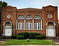
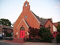
Saint Paul's Episcopal Church
Saint Paul's Episcopal Church in Lee's Summit was built in 1885. It has served the community for over a century.
Temple Site
The Temple Site in Independence is a very important religious site. It is a sacred place for some religious groups. It has been on the National Register since 1970.
Trinity Episcopal Church
The Trinity Episcopal Church in Independence was built in 1882. It is another historic church building.
Unity School of Christianity Historic District
The Unity School of Christianity Historic District is in Unity Village. It was founded in 1889. This district includes many buildings related to the Unity spiritual movement.
Harry S. Truman's Legacy
Jackson County is famous for being the home of President Harry S. Truman. Several places connected to him are on the National Register.
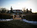
Harry S. Truman Historic District
The Harry S. Truman Historic District in Independence includes the neighborhood where President Truman lived. It gives us a picture of his life before and after his presidency.
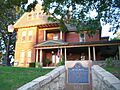
Harry S Truman National Historic Site
The Harry S Truman National Historic Site includes Truman's home at 219 N. Delaware Street. This is where he lived for many years. It also includes other buildings important to his life.
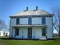
Harry S. Truman Farm Home
The Harry S. Truman Farm Home is in Grandview. This was the family farm where Truman worked as a young man. It shows a different side of his life before he became president.
Other Interesting Sites
Blue Mills
Blue Mills in Independence is a very old site. It was once home to a mill powered by water, then steam. Native Americans lived here first. Later, it became a field hospital during the Civil War. It has a rich and varied history.
Santa Fe Trail-Santa Fe Trail Park, Independence Trail Segments
The Santa Fe Trail-Santa Fe Trail Park, Independence Trail Segments marks parts of the famous Santa Fe Trail. This trail was a major route for trade and travel in the 1800s. It connected Missouri to Santa Fe, New Mexico.
Longview Farm
Longview Farm in Lee's Summit is a large historic farm. It was built in the early 1900s. It was known as "The World's Most Beautiful Farm" because of its modern design and many buildings.
Historic Districts
Many areas are listed as "historic districts." This means a group of buildings or an entire neighborhood is important because of its history or architecture.
- Bailey Family Farm Historic District in Lee's Summit.
- Bayles Addition Historic District in Lee's Summit.
- Andrew Drumm Institute in Independence.
- German Evangelical Pastors' Home Historic District in Blue Springs.
- Grandview Residential Historic District in Grandview.
- Howard Neighborhood Historic District in Lee's Summit.
- Lee's Summit Downtown Historic District in Lee's Summit.
- Morningside Acres Historic Ranch House District in Lee's Summit.
- Northeast Douglas Street Residential Historic District in Lee's Summit.
- Northeast Forest Avenue and Northeast Green Street Residential Historic District in Lee's Summit.
- Northeast Green and 1st Streets Residential Historic District in Lee's Summit.
- Southeast Grand Avenue and Fifth Street Residential Historic District in Lee's Summit.
- Southeast Green Street Historic Cottage District in Lee's Summit.
- Southeast Third Street and Southeast Corder Avenue Ranch House Historic District in Lee's Summit.
- Southeast Third Street Residential Historic District in Lee's Summit.
- Southwest Market Street Historic District in Lee's Summit.
- Southwest Third and Southwest Madison Historic District in Lee's Summit.
These districts help preserve the unique look and feel of these communities. They show how towns grew and changed over time.
Images for kids
-
The Bingham-Waggoner House in Independence.
-
The Dr. John S. Jr. and Harriet Smart Bryant House.
-
Fort Osage, a historic frontier fort.
-
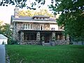
The Todd M. George, Sr., House in Lee's Summit.
-
The John and Adele Georgen House.
-
A building in the Howard Neighborhood Historic District.
-
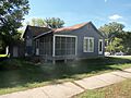
The Mollie and Josephine Hughes House.
-
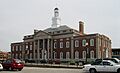
The Jackson County Courthouse.
-
The historic Jackson County Jail and Marshal's House.
-
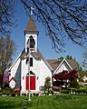
The Lee's Summit Christian Church Building.
-

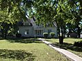
The Kritser House.
-
Longview Farm.
-

The Charles Minor House.
-
The Missouri Pacific Depot.
-

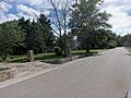
A home in the Northeast Douglas Street Residential Historic District.
-
A building in the Northeast Forest Avenue and Northeast Green Street Residential Historic District.
-
A building in the Northeast Green and 1st Streets Residential Historic District.
-
The Rice-Tremonti House in Raytown.
-
Saint Paul's Episcopal Church.
-
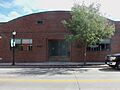
The Sherwood Manufacturing Company Building.
-
A building in the Southeast Grand Avenue and Fifth Street Residential Historic District.
-
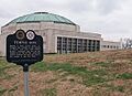
The Temple Site.
-
Trinity Episcopal Church.
-
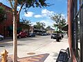
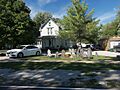
A view of the Harry S. Truman Historic District.
-
The Harry S Truman National Historic Site.
-

The Unity School of Christianity Historic District.
-
The Vaile Mansion.
-
The Harry S. Truman Farm Home.


.jpg)

