Lee's Summit, Missouri facts for kids
Quick facts for kids
Lee's Summit, Missouri
|
||
|---|---|---|

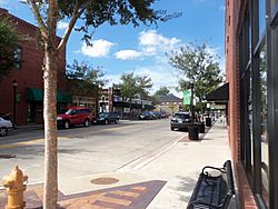
Downtown Lee's Summit
|
||
|
||

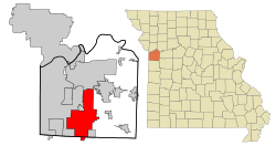
Location of Lee's Summit in Jackson County and the state of Missouri
|
||
| Country | United States | |
| State | Missouri | |
| Counties | Jackson, Cass | |
| Incorporated | October 28, 1865 | |
| Named for | Dr. Pleasant Lea | |
| Government | ||
| • Type | Council–manager | |
| Area | ||
| • Total | 65.91 sq mi (170.71 km2) | |
| • Land | 63.90 sq mi (165.49 km2) | |
| • Water | 2.02 sq mi (5.22 km2) | |
| Elevation | 1,024 ft (312 m) | |
| Population
(2020)
|
||
| • Total | 101,108 | |
| • Rank | 6th in Missouri 314th in the United States |
|
| • Density | 1,582.41/sq mi (610.97/km2) | |
| Time zone | UTC−6 (CST) | |
| • Summer (DST) | UTC−5 (CDT) | |
| ZIP Codes |
64015, 64063, 64064, 64081, 64082, 64083, 64086
|
|
| Area code(s) | 816 | |
| FIPS codes | 29095, 29037 | |
| GNIS feature ID | 2395669 | |
| Website | cityofls.net | |
Lee's Summit is a city in the state of Missouri, USA. It's a suburb located near Kansas City. Most of the city is in Jackson County, but a small part is in Cass County. In 2020, about 101,108 people lived there. This makes Lee's Summit the 6th largest city in Missouri and in the Kansas City area. It's also the biggest city in Missouri that isn't a county seat.
Contents
History of Lee's Summit
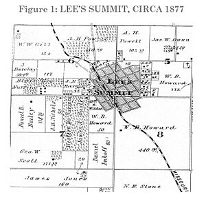
The city was first called "Town of Strother." It was started in October 1865 by William Bullitt Howard. He named it after his wife, Maria D. Strother. Howard came to Jackson County in 1842. During the American Civil War, he went back to Kentucky with his family. After the war, he returned. He knew the Missouri Pacific Railroad was planning a route nearby. So, he created the town in 1865.
In November 1868, the town's name changed to "Town of Lee's Summit." This was probably to honor an early settler, Dr. Pleasant John Graves Lea. Dr. Lea moved to Jackson County in 1849. He was killed in 1862 by a group called Kansas Jayhawkers.
When the railroad surveyors came through, people wanted to name the town after Dr. Lea. His farm was on the highest point along the tracks. Also, he was killed near where the train station would be. So, they chose "Lea's Summit." The "summit" part meant it was the highest point on the railroad between St. Louis and Kansas City.
However, the name was misspelled as "Lees Summit" on a train car used as a station. It was also misspelled on a sign and in the train schedule. This misspelling stuck, and the name has been "Lee's Summit" ever since.
Because the name was already being used with two "e's," the town asked the state government to officially change it. In 1868, it became "Town of Lee's Summit." It's unusual to have an apostrophe in a place name. Most places like Harpers Ferry don't use them.
A famous estate called Longview Farm was built in 1913 by R. A. Long, a lumber company owner. It had a large mansion, barns, and many buildings on 1,700 acres. Today, one of the horse barns is a school called Longview Farm Elementary. The church and mansion are now historic places. Other parts of the farm became Longview Lake and Longview Community College. Lee's Summit is also home to Missouri Town 1855, which shows what a town looked like in the 1850s.
Geography and Location
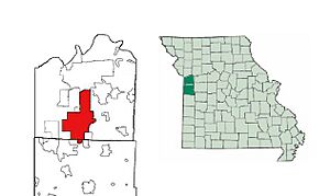
Lee's Summit is located near Missouri's western border with Kansas. It's part of the larger Kansas City area. The city borders Kansas City to the west and north. To the north, it borders Independence, Missouri. Smaller, more rural towns are to its south and east.
The city covers about 65.9 square miles (170.7 square kilometers). Most of this area, about 63.9 square miles (165.5 square kilometers), is land. The rest, about 2.0 square miles (5.2 square kilometers), is water.
Population and People
| Historical population | |||
|---|---|---|---|
| Census | Pop. | %± | |
| 1880 | 693 | — | |
| 1890 | 1,369 | 97.5% | |
| 1900 | 1,453 | 6.1% | |
| 1910 | 1,455 | 0.1% | |
| 1920 | 1,467 | 0.8% | |
| 1930 | 2,035 | 38.7% | |
| 1940 | 2,263 | 11.2% | |
| 1950 | 2,554 | 12.9% | |
| 1960 | 8,267 | 223.7% | |
| 1970 | 16,230 | 96.3% | |
| 1980 | 28,741 | 77.1% | |
| 1990 | 46,418 | 61.5% | |
| 2000 | 70,700 | 52.3% | |
| 2010 | 91,364 | 29.2% | |
| 2020 | 101,108 | 10.7% | |
| 2023 (est.) | 104,638 | 14.5% | |
| U.S. Decennial Census | |||
In 2020, Lee's Summit had 101,108 people living in 37,664 households. About 35% of households had children under 18. Most households (58.6%) were married couples.
The population is diverse. About 78.6% of residents are white, 8.9% are black or African-American, and 2.4% are Asian. About 5.3% of the population is Hispanic or Latino.
The average age in the city is about 38.4 years old. About 25.8% of the people are under 18.
Economy and Jobs
Lee's Summit has many different types of jobs. Here are some of the biggest employers in the city:
| # | Employer | # of employees |
|---|---|---|
| 1 | Lee's Summit R-7 schools | 3,116 |
| 2 | Homeland Security - USCIS | 3,000 |
| 3 | Saint Luke's East Hospital | 1,430 |
| 4 | Truman Medical Center - Lakewood | 1,200 |
| 5 | John Knox Village | 1,000 |
| 6 | GEHA Holdings Inc. | 880 |
| 7 | City of Lee's Summit | 786 |
| 8 | Lee's Summit Medical Center | 730 |
| 9 | ReDiscover | 700 |
| 10 | CVS Caremark Call Center | 450 |
| 11 | Metropolitan Community College - Longview | 406 |
| 12 | Quest Diagnostics | 350 |
| 13 | Unity Village | 325 |
| 14 | Aspen Contracting | 300 |
| 15 | Viracor-Eurofins | 290 |
| 16 | IPL Plastics | 271 |
| 17 | R&D Leverage | 265 |
Education in Lee's Summit
Students in Lee's Summit attend schools in three different public school districts:
- Lee's Summit R-VII School District
- Blue Springs R-IV School District
- Raymore-Peculiar R-II School District
There are also several private schools, including Summit Christian Academy and Our Lady of Presentation Catholic School.
For higher education, Longview Community College is located in Lee's Summit. The Summit Technology Center, a branch of the University of Central Missouri, is also here.
Lee's Summit has three public libraries that are part of the Mid-Continent Public Library system.
Climate
Lee's Summit has four distinct seasons. Winters are cold, and summers are hot and humid.
| Climate data for Lee's Summit Municipal Airport and James A. Reed Memorial Wildlife Area | |||||||||||||
|---|---|---|---|---|---|---|---|---|---|---|---|---|---|
| Month | Jan | Feb | Mar | Apr | May | Jun | Jul | Aug | Sep | Oct | Nov | Dec | Year |
| Record high °F (°C) | 73 (23) |
80 (27) |
87 (31) |
91 (33) |
91 (33) |
103 (39) |
108 (42) |
107 (42) |
107 (42) |
95 (35) |
82 (28) |
73 (23) |
108 (42) |
| Mean maximum °F (°C) | 59 (15) |
65 (18) |
77 (25) |
83 (28) |
88 (31) |
93 (34) |
98 (37) |
98 (37) |
92 (33) |
85 (29) |
73 (23) |
63 (17) |
99 (37) |
| Mean daily maximum °F (°C) | 39.0 (3.9) |
44.3 (6.8) |
55.4 (13.0) |
65.5 (18.6) |
74.8 (23.8) |
84.0 (28.9) |
88.3 (31.3) |
86.9 (30.5) |
79.0 (26.1) |
67.1 (19.5) |
54.0 (12.2) |
43.2 (6.2) |
65.1 (18.4) |
| Daily mean °F (°C) | 30.6 (−0.8) |
35.1 (1.7) |
45.4 (7.4) |
55.5 (13.1) |
65.3 (18.5) |
74.7 (23.7) |
79.0 (26.1) |
77.3 (25.2) |
69.0 (20.6) |
57.2 (14.0) |
45.1 (7.3) |
34.7 (1.5) |
55.7 (13.2) |
| Mean daily minimum °F (°C) | 22.1 (−5.5) |
25.9 (−3.4) |
35.4 (1.9) |
45.5 (7.5) |
55.9 (13.3) |
65.4 (18.6) |
69.7 (20.9) |
67.6 (19.8) |
59.0 (15.0) |
47.2 (8.4) |
36.2 (2.3) |
26.3 (−3.2) |
46.3 (8.0) |
| Mean minimum °F (°C) | −3 (−19) |
2 (−17) |
13 (−11) |
27 (−3) |
39 (4) |
50 (10) |
56 (13) |
54 (12) |
40 (4) |
28 (−2) |
16 (−9) |
2 (−17) |
−6 (−21) |
| Record low °F (°C) | −19 (−28) |
−15 (−26) |
−5 (−21) |
11 (−12) |
28 (−2) |
35 (2) |
48 (9) |
43 (6) |
29 (−2) |
7 (−14) |
0 (−18) |
−25 (−32) |
−25 (−32) |
| Average precipitation inches (mm) | 0.96 (24) |
1.43 (36) |
2.14 (54) |
4.19 (106) |
5.70 (145) |
4.95 (126) |
4.57 (116) |
4.54 (115) |
3.07 (78) |
3.39 (86) |
2.05 (52) |
1.35 (34) |
38.34 (972) |
| Average snowfall inches (cm) | 2.7 (6.9) |
2.8 (7.1) |
1.3 (3.3) |
0.2 (0.51) |
0.0 (0.0) |
0.0 (0.0) |
0.0 (0.0) |
0.0 (0.0) |
0.0 (0.0) |
0.0 (0.0) |
0.5 (1.3) |
1.8 (4.6) |
4.5 (11) |
| Average precipitation days (≥ 0.01 in) | 5 | 5 | 8 | 10 | 12 | 10 | 9 | 9 | 8 | 9 | 7 | 6 | 98 |
| Average snowy days (≥ 0.1 in) | 2 | 2 | 1 | 0 | 0 | 0 | 0 | 0 | 0 | 0 | 0 | 2 | 9 |
| Source: NOAA | |||||||||||||
City Infrastructure
Transportation
The Historic Jefferson Highway runs through Lee's Summit. It was once known as the "Palm to Pine" highway.
Major Roads
 I-470 is a highway that goes through Lee's Summit and into southern Kansas City.
 US 40 forms part of Lee's Summit's northern border with Independence.
 US 50 connects with other major highways and then becomes just US 50 in Lee's Summit.
 Route 150 links southern Lee's Summit and Grandview to areas in Kansas.
 Route 291 connects Lee's Summit to other cities like Harrisonville, Independence, and Liberty. It also goes to the KCI Airport.
 Route 350 is a connector highway that joins other major roads.
Other Ways to Travel
- Lee's Summit (Amtrak station) (train station)
- Lee's Summit Municipal Airport (local airport)
Healthcare
Lee's Summit has two main hospitals that offer emergency services: Lee's Summit Medical Center and Saint Luke's East Hospital.
Media
You can find out what's happening in Lee's Summit through these news sources:
- Lee's Summit Journal
- The Kansas City Star
- The Lee's Summit Tribune
Famous People from Lee's Summit
Many notable people have connections to Lee's Summit, including:
- Megan Anderson, a mixed martial artist
- Evan Boehm, an NFL football player
- Paul Coverdell, a former U.S. Senator
- Mark Curp, a former world record holder in half marathon
- Robert K. Dixon, a Nobel Laureate and scientist
- Forrest Griffith, an NFL football player
- Monte Harrison, an MLB baseball player
- James Krause, a mixed martial artist
- Alex Lange, an MLB baseball player
- KC Lightfoot, an Olympic pole vaulter
- Angela Lindvall, a model and actress
- Audrey Lindvall, a model
- Drew Lock, an NFL football player
- Katherine McNamara, an actress
- Mike Metheny, a jazz musician
- Pat Metheny, a jazz musician
- Trevor Rosenthal, an MLB baseball player
- Sam B. Strother, a former Mayor of Kansas City
- Matt Tegenkamp, an Olympic long-distance runner
- Freddie Williams II, a comic book artist
- Bob Younger, Cole Younger, Jim Younger, and John Younger, members of the James–Younger Gang
- Erik Palmer-Brown, a soccer player
- Felix Anudike-Uzomah, an NFL football player
See also
 In Spanish: Lee's Summit (Misuri) para niños
 | May Edward Chinn |
 | Rebecca Cole |
 | Alexa Canady |
 | Dorothy Lavinia Brown |


