
Raytown, Missouri facts for kids
Quick facts for kids
Raytown, Missouri
|
|
|---|---|
| City of Raytown | |

Aerial view of Raytown
|
|

Location of Raytown in Jackson County and Missouri
|
|
| Country | United States |
| State | Missouri |
| County | Jackson |
| Area | |
| • Total | 9.97 sq mi (25.83 km2) |
| • Land | 9.93 sq mi (25.72 km2) |
| • Water | 0.04 sq mi (0.11 km2) |
| Elevation | 1,014 ft (309 m) |
| Population
(2020)
|
|
| • Total | 30,012 |
| • Density | 3,022.36/sq mi (1,166.99/km2) |
| Time zone | UTC−6 (Central (CST)) |
| • Summer (DST) | UTC−5 (CDT) |
| ZIP codes |
64129, 64133, 64138
|
| Area code(s) | 816 |
| FIPS code | 29-60788 |
| GNIS feature ID | 0735817 |
| Website | The City of Raytown web site |
Raytown is a city located in Jackson County, Missouri, United States. It is a suburb of the much larger Kansas City. In 2020, about 30,012 people lived here. Raytown is part of the wider Kansas City metropolitan area. The current mayor of Raytown is Michael McDonough.
Contents
History of Raytown
Early Settlers and Land Development
The area that is now Raytown started to grow in the 1800s. Pioneers, or early settlers, traveled west along famous routes called the Three Trails. They were looking for good land and water. In 1826, this land became part of the state of Missouri. It cost $800 at the time.
Jackson County was created in 1827. It was named after President Andrew Jackson. A large part of the county, called Township 49, was not sold with the other lands by mistake. Because of this, it was known as "The Lost Township." People moved into this area and lived there without owning the land, a practice called squatting. This continued until the land was properly measured and sold in 1843.
Blue Ridge and Important Homes
The pioneers found an area in Raytown with high, wooded hills. These hills reminded them of the Blue Ridge Mountains where many of them used to live. So, they named this area Blue Ridge. The nearby rivers were called the Big Blue and the Little Blue rivers.
The Rice-Tremonti Home is a historic building that still stands in Raytown today. It was built in 1844 by Archibald Rice and his family. This home was located right on the Santa Fe Trail, a very important path for travelers.
How Raytown Got Its Name
In 1860, people in Jackson County asked for a better road. They wanted to connect the southern part of the county to Independence in the north. This led to the creation of Raytown Road. This road went north from High Grove Road. It crossed the Little Blue River at a rocky crossing. Then, it joined the Santa Fe Trail near William Ray's blacksmith shop. Many parts of the original Raytown Road are still used today.
William Ray opened his blacksmith shop around 1848. It was on the Santa Fe Trail in Jackson County. The small community that grew around his shop was first called "Ray's Town." Later, in 1854, it became known simply as "Raytown." Today, a historical marker shows where William Ray's shop once stood. You can find it at the corner of 63rd Street and Raytown Road.
Geography of Raytown
Raytown covers a total area of about 9.97 square miles (25.83 square kilometers). Most of this area, about 9.93 square miles (25.72 square kilometers), is land. A small part, about 0.04 square miles (0.11 square kilometers), is water.
Population and People
| Historical population | |||
|---|---|---|---|
| Census | Pop. | %± | |
| 1960 | 17,083 | — | |
| 1970 | 33,632 | 96.9% | |
| 1980 | 31,831 | −5.4% | |
| 1990 | 30,601 | −3.9% | |
| 2000 | 30,388 | −0.7% | |
| 2010 | 29,526 | −2.8% | |
| 2020 | 30,012 | 1.6% | |
| U.S. Decennial Census | |||
Raytown's Population in 2020
The 2020 census counted 30,012 people living in Raytown. There were 12,720 households and 7,019 families. The population density was about 3,022 people per square mile.
People of different backgrounds make up Raytown's population:
- About 53.34% were white.
- About 32.68% were black or African-American.
- Smaller groups included Native American, Asian, and Pacific Islander people.
- About 9.17% of people identified as two or more races.
- About 6.6% of the population was Hispanic or Latino.
About 19.8% of the people in Raytown were under 18 years old. The average age was about 41.1 years.
Economy and Jobs
Major Employers in Raytown
Many people in Raytown work for different companies and organizations. Here are some of the top employers in the city:
| # | Employer | Number of Employees |
|---|---|---|
| 1 | Raytown Quality Schools | 1,300 |
| 2 | Wal-Mart | 400 |
| 3 | Hy-Vee Food & Drug Store | 350 |
| 4 | USA 800 | 309 |
| 5 | KCP&L | 300 |
| 6 | Stratford Development Corporation | 235 |
| 7 | KC Chiefs Football Club | 192 |
| 8 | Southeast Enterprises, Inc. | 190 |
| 9 | City of Raytown | 153 |
| 10 | Kansas City Zoo | 151 |
| 11 | H & H Color Lab | 150 |
| 12 | Cosentino's Food Stores | 150 |
| 13 | Blue Ridge Bank and Trust Co. | 150 |
| 14 | Two Rivers Behavioral Health System | 149 |
| 15 | Shamrock Cabinet & Fixtures Corp | 100 |
Education in Raytown
School Districts Serving Raytown
Most of Raytown is served by the Raytown C-2 School District. This district runs public schools for students in the area. A very small southern part of Raytown is part of the Hickman Mills C-1 School District.
The Raytown C-2 School District includes:
- Raytown High School
- Raytown South High School
Public Library
Raytown also has a public library. It is a branch of the Mid-Continent Public Library system. Libraries are great places to read books, study, and learn new things!
Images for kids
-
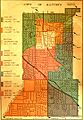
A street map of Raytown showing when different areas were added to the city.

See also
 In Spanish: Raytown (Misuri) para niños
