
National Register of Historic Places listings in Kern County, California facts for kids

Kern County, located in sunny California, is home to many amazing places that have a special spot in history! These places are so important that they are listed on the National Register of Historic Places. This is like a special list kept by the United States government to protect buildings, sites, and objects that tell us about the past.
There are 26 historic places and areas in Kern County that are on this list. Four of these are even more special and are called National Historic Landmarks. They are super important to the history of the entire country!
Historic Places in Kern County
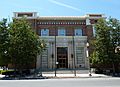
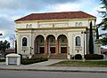
Bakersfield Californian Building
The Bakersfield Californian Building is located in Bakersfield. This building was added to the National Register in 1983. It's a significant part of the city's history.
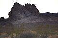
Bandit Rock
Also known as Robbers Roost, Bandit Rock is found southwest of Inyokern. This unique rock formation was listed in 1975. It's a natural landmark with a cool name!
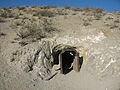
Burro Schmidt's Tunnel
Near Ridgecrest, you can find Burro Schmidt's Tunnel. This amazing tunnel was dug by one person, William "Burro" Schmidt, over 32 years! It was added to the National Register in 2003.
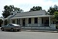
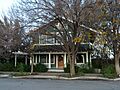
Errea House
The Errea House is a historic home in Tehachapi. It was recognized for its historical importance in 1997.
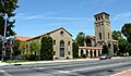
First Baptist Church
The First Baptist Church in Bakersfield is a beautiful old church building. It was added to the National Register of Historic Places in 1979.
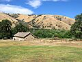
Fort Tejon
Fort Tejon is an old military fort located northwest of Lebec. It was an important place in California's early history and was listed in 1971.
The Fort (Taft)
In Taft, there's a unique building known as The Fort. It was added to the National Register in 1981.
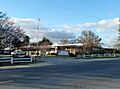
The Forty Acres
The Forty Acres, located in Delano, is a very important place for American labor history. It was a key center for the United Farm Workers movement and was made a National Historic Landmark in 2008.
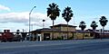
Green Hotel
The Green Hotel in Shafter is a historic hotel building. It was added to the National Register in 1989.
Courtlandt Gross House
The Courtlandt Gross House is another historic home in Tehachapi. It was listed in 1987.
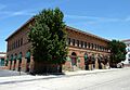
Jastro Building
The Jastro Building is a historic structure in Bakersfield. It was recognized for its historical value in 1983.
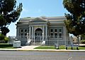
Kern Branch, Beale Memorial Library
This historic library branch in Bakersfield was an important community center. It was added to the National Register in 1981.
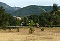
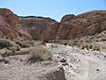
Last Chance Canyon
Last Chance Canyon, near Johannesburg, is a historic district. It was listed in 1972.
Long Canyon Village Site
The Long Canyon Village Site near South Lake is an archaeological site. It was added to the National Register in 1980.
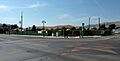
National Farm Workers Association Headquarters
This building in Delano was the headquarters for the National Farm Workers Association. It played a big role in the fight for farm workers' rights and was listed in 2015.
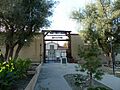
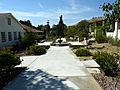
Nuestra Senora Reina de la Paz
Located in Keene, Nuestra Senora Reina de la Paz is also known as the National Chavez Center. It was the home and final resting place of civil rights leader Cesar Chavez. It became a National Historic Landmark in 2012.
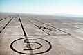
Rogers Dry Lake
Rogers Dry Lake is a large dry lakebed located at Edwards Air Force Base in the Mojave Desert. It's famous for being a landing site for many historic aircraft, including the Space Shuttle. It was designated a National Historic Landmark in 1985.
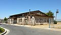
Santa Fe Passenger and Freight Depot
The Santa Fe Passenger and Freight Depot in Shafter was an important train station. It was added to the National Register in 1982.
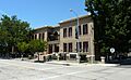
Shafter Research Station
The Shafter Research Station in Shafter is a historic agricultural research facility. It was listed in 1997.
Tehachapi Railroad Depot
The Tehachapi Railroad Depot in Tehachapi was a historic train station. It burned down in 2008 but is being rebuilt to look like the original. It was listed in 1999.
Tevis Block
The Tevis Block is a historic building in Bakersfield. It was added to the National Register in 1984.
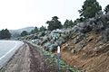
Walker Pass
Walker Pass is a historic mountain pass located northeast of Bakersfield. It was an important route for pioneers and explorers. It became a National Historic Landmark in 1966.
Wasco Union High School Auditorium
The auditorium at Wasco Union High School in Wasco is a historic building. It was listed in 1997.
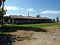
Weedpatch Camp
Weedpatch Camp, located in Bakersfield, is a historic farm labor camp. It was made famous by John Steinbeck's novel The Grapes of Wrath. It was added to the National Register in 1996.
Images for kids
-
Bakersfield Californian Building
-
Bandit Rock
-
Burro Schmidt's Tunnel
-
Errea House
-
First Baptist Church
-
Fort Tejon
-
The Fort (Taft)
-
The Forty Acres
-
Green Hotel
-
Courtlandt Gross House
-
Jastro Building
-
Kern Branch, Beale Memorial Library
-
Last Chance Canyon
-
Nuestra Senora Reina de la Paz
-
Rogers Dry Lake
-
Santa Fe Passenger and Freight Depot
-
Shafter Research Station
-
Tehachapi Railroad Depot
-
Tevis Block
-
Walker Pass
-
Wasco Union High School Auditorium
-
Weedpatch Camp


