
National Register of Historic Places listings in Lamoille County, Vermont facts for kids

Welcome to Lamoille County, Vermont! This beautiful area is home to many special places that are listed on the National Register of Historic Places. This is like a special list kept by the United States government. It helps protect important buildings, bridges, and areas that tell us about history.
When a place is on this list, it means it's really important to our country's past. It helps make sure these places are kept safe for future generations, like you, to learn from and enjoy. In Lamoille County, there are 29 different places on this list. Let's explore some of them!
| Addison - Bennington - Caledonia - Chittenden - Essex - Franklin - Grand Isle - Lamoille - Orange - Orleans - Rutland - Washington - Windham - Windsor |
Contents
Cool Historic Bridges
Lamoille County has many amazing old bridges, especially covered bridges! These bridges are like tunnels made of wood that protect the bridge structure from weather.
Covered Bridges
- Fisher Covered Railroad Bridge: This cool bridge is southeast of Wolcott and crosses the Lamoille River. It was added to the list in 1974.
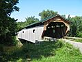
- Gates Farm Covered Bridge: You can find this bridge off Route 15 in Cambridge, crossing the Seymour River. It became historic in 1974.
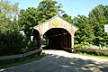
- Gold Brook Covered Bridge: Located south of Stowe, this bridge is also known as Emily's Bridge. It's famous for local legends and was listed in 1974.
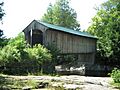
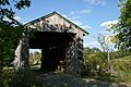
- Grist Mill Covered Bridge: East of Cambridge, this bridge crosses the Brewster River. It's another historic gem from 1974.
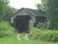
- Jaynes Covered Bridge: Northeast of Waterville, this bridge crosses the North Branch of the Lamoille River. It was added to the list in 1974.
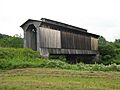
- Mill Covered Bridge: This bridge is off Route 109 in Belvidere, crossing the North Branch of the Lamoille River. It joined the list in 1974.
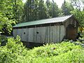
- Montgomery Covered Bridge: Another bridge northeast of Waterville, also over the North Branch of the Lamoille River. It was listed in 1974.
- Morgan Covered Bridge: Off Route 109 in Belvidere, this bridge also crosses the North Branch of the Lamoille River. It became historic in 1974.
- Poland Covered Bridge: You'll find this bridge off Route 15 in Cambridge Junction, over the Lamoille River. It's also called the Cambridge Junction Bridge and was listed in 1974. A judge named Poland helped make sure it was built!
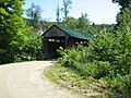
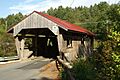
- Power House Covered Bridge: This bridge is off Route 100C in Johnson, crossing the Gihon River. It was added to the list in 1974.
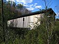
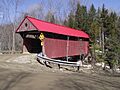
- Red Covered Bridge: Southwest of Morristown, this bridge crosses Sterling Brook. It's a bright red landmark from 1974.
- Scribner Covered Bridge: East of Johnson, this bridge crosses the Gihon River. It was listed in 1974.
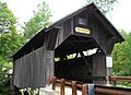
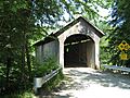
- Village Covered Bridge: This bridge is in Waterville, over the North Branch of the Lamoille River. It became historic in 1974.
Other Bridges
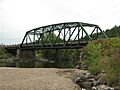
- Bridge 6: This bridge is on Railroad Street in Johnson. It was listed in 2007.
- Jeffersonville Bridge: This bridge was on Route 108 over the Lamoille River in Cambridge. It was listed in 1991 but was replaced in 2014.
- Lamoille River Route 15-A Bridge: This bridge was on Route 15-A over the Lamoille River in Morristown. It was a special type of bridge built in 1928 but was taken down in 2007.
Important Buildings and Districts
Many buildings and even whole parts of towns in Lamoille County are considered historic. These places show us how people lived and worked long ago.
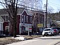
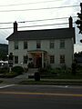
- Cambridge Meetinghouse: Located at 85 Church Street in Jeffersonville, this building used to be a church for different groups. Now, it's the Cambridge Town Offices and a post office! It was listed in 1981.
- Johnson Railroad Depot: This old train station was on Railroad Street in Johnson. It was listed in 1980, but it might have been taken down since then.
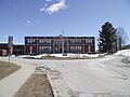
- Lamoille County Courthouse: This important building is on Main Street in Hyde Park. It's where legal decisions for the county are made and was listed in 1996.
- Nye Block: This building was at Main and Railroad Streets in Johnson. It was listed in 1977 but was sadly destroyed by a fire in 1986.
- Peoples Academy-Copley Building, Grout Observatory and Community Bandshell: This group of buildings is at 5 Copley Avenue in Morristown. It includes a school building, an observatory for looking at stars, and a place for outdoor concerts. It was listed in 1996.
Historic Districts
Sometimes, a whole area or neighborhood is considered historic because it has many old buildings that together tell a story.
- Jeffersonville Historic District: This area includes Church, Main, Maple, and School Streets, Carlton Avenue, Route 108, and Brewster Avenue in Cambridge. It was listed in 1987.
- Morrisville Historic District: This district covers Portland, Main, Railroad, and Foundry Streets in Morrisville. It was listed in 1983 and later expanded to include more streets.
- Moscow Village Historic District: This historic area is in Stowe and includes Moscow Road, Shaw Hill Road, Adams Mill Road, and River Road. It was listed in 2008.
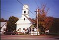
- Stowe Village Historic District: This district covers parts of Route 100 and Route 108 in Stowe. It was listed in 1978.
- Waterville Village Historic District: This area in Waterville includes Route 109, Oakes Road, Church Street, Griffin Road, Fox Hill Road, Beals Hill Road, and Lapland Road. It was listed in 2007.
Parks and Camps
Even natural areas and old camps can be historic!
- Elmore State Park: This beautiful park is at 856 Route 12 in Elmore. It's a great place to enjoy nature and was listed in 2002.
- Stowe CCC Side Camp: This camp was located at 6992 Mountain Road in Stowe. It was part of the Civilian Conservation Corps (CCC), a program during the Great Depression that helped young men find work building parks and other public projects. It was listed in 2002.
Images for kids
-
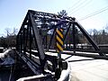
Bridge 6 in Johnson
-
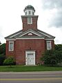
Cambridge Meetinghouse
-
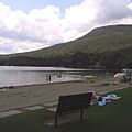
Lake Elmore in Elmore State Park
-
Fisher Covered Railroad Bridge
-
Gates Farm Covered Bridge
-
Gold Brook Covered Bridge, also known as Emily's Bridge
-
Grist Mill Covered Bridge
-
Jaynes Covered Bridge
-
Jeffersonville Bridge (replaced in 2014)
-
A street in the Jeffersonville Historic District
-
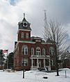
Lamoille County Courthouse
-
Mill Covered Bridge in Belvidere
-
Montgomery Covered Bridge
-
Morgan Covered Bridge
-
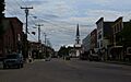
Downtown Morrisville, part of the Historic District
-
Peoples Academy-Copley Building
-
Poland Covered Bridge (Cambridge Junction Bridge)
-
Power House Covered Bridge
-
Red Covered Bridge
-
Scribner Covered Bridge
-
The Butler House in Stowe Village Historic District
-
Village Covered Bridge (Church Street Covered Bridge)
-
A building in the Waterville Village Historic District


