
National Register of Historic Places listings in Grand Isle County, Vermont facts for kids

Welcome to Grand Isle County, Vermont! This special place is home to many historic buildings and sites. These important locations are listed on the National Register of Historic Places. This list helps protect places that are important to American history and culture.
Think of the National Register as a special club for old buildings, homes, and other sites. When a place is on this list, it means it's been recognized as historically important. It also helps make sure these places are cared for and preserved for future generations. In Grand Isle County, there are 10 amazing places that have earned a spot on this list!
Contents
What is the National Register of Historic Places?
The National Register of Historic Places is the official list of the nation's historic places worth saving. It's part of a program run by the United States government. This program encourages people to identify, evaluate, and protect historic and archaeological resources.
Why are places listed?
Places are listed for many reasons. Maybe a famous person lived there, or an important event happened there. Sometimes, a building is listed because it's a great example of a certain type of architecture. Being on the list helps people understand and appreciate the history around them. It also means these places might get special grants or tax benefits to help with their upkeep.
Historic Places in Grand Isle County
Grand Isle County has a rich history, and its historic places tell many stories. From old churches to unique homes, each site has something special to share. Here are the places in Grand Isle County that are on the National Register of Historic Places:
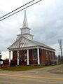
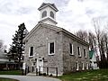
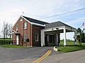
Congregational Church-Grand Isle
- Location: Grand Isle
- Listed: March 2, 2001
This beautiful church has been a central part of the Grand Isle community for many years. It stands as a reminder of the early settlers and their faith.
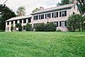
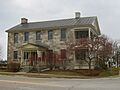
Gordon-Center House
- Location: Grand Isle
- Listed: April 17, 1986
This historic house gives us a peek into what life was like in Grand Isle long ago. It shows the architectural styles popular in its time.
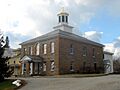
Grand Isle County Courthouse
- Location: North Hero
- Listed: January 11, 1996
The courthouse in North Hero is where many important decisions for the county have been made. It's a key building in the county's civic history.
Ira Hill House
- Location: Isle La Motte
- Listed: November 13, 2003
The Ira Hill House is another example of the historic homes found in Grand Isle County. It adds to the rich history of Isle La Motte.
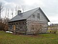
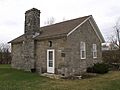
Hyde Log Cabin
- Location: Grand Isle
- Listed: March 11, 1971
This is one of the oldest log cabins in the United States! It was built in 1783 by Jedediah Hyde Jr. and shows how early settlers lived. It's a truly special piece of Vermont's past.
Methodist Episcopal Church of Isle La Motte
- Location: Isle La Motte
- Listed: March 2, 2001
Like the Congregational Church, this church has served the community of Isle La Motte for many years. It's an important part of the town's heritage.
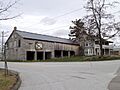
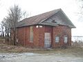
Rutland Railroad Pumping Station
- Location: Alburg
- Listed: December 30, 1999
This station played a role in the history of railroads in Vermont. It reminds us of a time when trains were a main way to travel and transport goods.
South Hero Inn
- Location: South Hero
- Listed: April 16, 1975
The South Hero Inn was once a busy place for travelers. Inns like this were vital stops for people journeying through the area in earlier times.
South Stone School House
- Location: Isle La Motte
- Listed: January 31, 1997
This old schoolhouse shows us what education was like for children many years ago. It's a great example of a historic one-room school.
U.S. Inspection Station-Alburg Springs, Vermont
- Location: Alburg
- Listed: September 10, 2014
This station was important for checking people and goods crossing the border. It tells a story about the history of travel and trade in the region.
Images for kids
-
Congregational Church-Grand Isle
-
Gordon-Center House
-
Grand Isle County Courthouse
-
Ira Hill House
-
Hyde Log Cabin
-
Methodist Episcopal Church of Isle La Motte
-
Rutland Railroad Pumping Station
-
South Hero Inn
-
South Stone School House
-
U.S. Inspection Station-Alburg Springs, Vermont


