
National Register of Historic Places listings in North Dakota facts for kids
North Dakota is home to many amazing places that tell stories about its past! The National Register of Historic Places in North Dakota is like a special list of these important buildings, sites, and objects. It helps protect and celebrate places that are significant to the history, architecture, archaeology, engineering, or culture of the state and the whole country.
There are 461 properties and historic districts on this list in North Dakota. You can find these special places in 52 out of North Dakota's 53 counties!
| Adams | Barnes | Benson | Billings | Bottineau | Bowman | Burke | Burleigh | Cass | Cavalier | Dickey | Divide | Dunn | Eddy | Emmons | Foster | Golden Valley | Grand Forks | Grant | Griggs | Hettinger | Kidder | La Moure | Logan | McHenry | McIntosh | McKenzie | McLean | Mercer | Morton | Mountrail | Nelson | Oliver | Pembina | Pierce | Ramsey | Ransom | Renville | Richland | Rolette | Sargent | Sheridan | Sioux | Slope | Stark | Steele | Stutsman | Towner | Traill | Walsh | Ward | Wells | Williams |
Historic Places Across North Dakota's Counties
This section shows how many historic places are listed in each county. These numbers are approximate and change sometimes as new places are added or, very rarely, removed from the list.
| County | Number of Sites | |
|---|---|---|
| 1 | Adams | 3 |
| 2 | Barnes | 13 |
| 3 | Benson | 7 |
| 4 | Billings | 10 |
| 5 | Bottineau | 3 |
| 6 | Bowman | 2 |
| 7 | Burke | 3 |
| 8 | Burleigh | 24 |
| 9 | Cass | 35 |
| 10 | Cavalier | 2 |
| 11 | Dickey | 8 |
| 12 | Divide | 5 |
| 13 | Dunn | 4 |
| 14 | Eddy | 4 |
| 15 | Emmons | 17 |
| 16 | Foster | 6 |
| 17 | Golden Valley | 2 |
| 18 | Grand Forks | 67 |
| 19 | Grant | 4 |
| 20 | Griggs | 4 |
| 21 | Hettinger | 5 |
| 22 | Kidder | 3 |
| 23 | LaMoure | 2 |
| 24 | Logan | 2 |
| 25 | McHenry | 12 |
| 26 | McIntosh | 8 |
| 27 | McKenzie | 4 |
| 28 | McLean | 7 |
| 29 | Mercer | 8 |
| 30 | Morton | 10 |
| 31 | Mountrail | 3 |
| 32 | Nelson | 3 |
| 33 | Oliver | 1 |
| 34 | Pembina | 11 |
| 35 | Pierce | 7 |
| 36 | Ramsey | 14 |
| 37 | Ransom | 9 |
| 38 | Renville | 2 |
| 39 | Richland | 12 |
| 40 | Rolette | 3 |
| 41 | Sargent | 1 |
| 42 | Sheridan | 2 |
| 43 | Sioux | 0 |
| 44 | Slope | 2 |
| 45 | Stark | 5 |
| 46 | Steele | 3 |
| 47 | Stutsman | 11 |
| 48 | Towner | 1 |
| 49 | Traill | 22 |
| 50 | Walsh | 15 |
| 51 | Ward | 15 |
| 52 | Wells | 5 |
| 53 | Williams | 8 |
| (duplicates) | (2) | |
| TOTAL | 437 | |
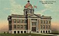
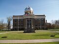
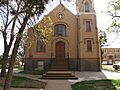
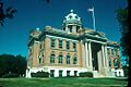
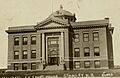
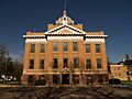
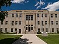
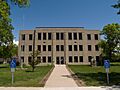
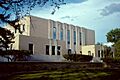
Adams County
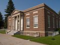
Adams County has three places on the National Register. One of them is the Adams County Courthouse in Hettinger, a historic building where local government decisions are made.
Barnes County
Barnes County has 13 historic places. You can find more details about them here: National Register of Historic Places listings in Barnes County, North Dakota.
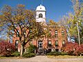
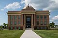
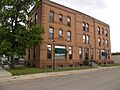
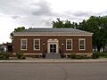
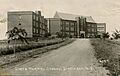
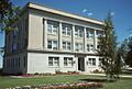
Benson County
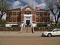
Benson County has seven historic places.
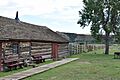
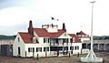
Fort Totten State Historic Site
Fort Totten is a very old military fort south of Fort Totten, built in 1867. It's now a state historic site where you can learn about its past.
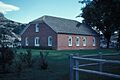
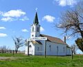
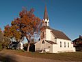
Viking Lutheran Church
The Viking Lutheran Church is a beautiful old church located southeast of Maddock. It was added to the Register in 1979.
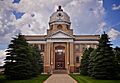
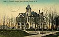
Billings County
Billings County has ten historic places. Many of them are in or near Medora, a town with a rich history.
Chateau de Mores
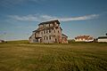
The Chateau de Mores is a historic mansion southwest of Medora. It was the home of a French nobleman named Marquis de Mores, who founded Medora in the late 1800s.
De Mores Packing Plant Ruins
Near the Chateau, you can find the ruins of the De Mores Packing Plant. This was a meatpacking factory that the Marquis de Mores built, showing an important part of the area's early industry.
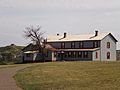
Peaceful Valley Ranch
The Peaceful Valley Ranch is located north of Medora, inside Theodore Roosevelt National Park. It's a historic ranch that gives a glimpse into the life of early settlers.
Bottineau County
Bottineau County has three historic places.
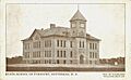
Old Main, North Dakota School of Forestry
Old Main is a building at the North Dakota School of Forestry in Bottineau. It was listed in 2006.
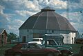
Bowman County
Bowman County has two historic places.
Fort Dilts
Fort Dilts is a historic site near Rhame. It was a temporary fort built by settlers in 1864 during a conflict.
Burke County
Burke County has three historic places.
Burke County Courthouse
The Burke County Courthouse in Bowbells is a historic building that serves as the county's main government office.
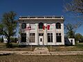
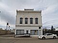
Portal State Bank
The Portal State Bank building in Portal is another historic site in the county, added to the list in 1996.
Burleigh County
Burleigh County has 24 historic places. You can find more details about them here: National Register of Historic Places listings in Burleigh County, North Dakota.
Cass County
Cass County has 35 historic places. You can find more details about them here: National Register of Historic Places listings in Cass County, North Dakota.
Cavalier County
Cavalier County has two historic places.
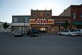
Roxy Theatre
The Roxy Theatre in Langdon is a historic movie theater. It was added to the National Register in 1998.
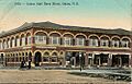
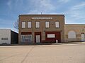
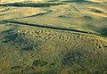
Dickey County
Dickey County has eight historic places.
Dickey County Courthouse
The Dickey County Courthouse in Ellendale is a historic building that was listed in 1980.
Ellendale Opera House Block
The Ellendale Opera House Block is a historic building in Ellendale that once housed an opera house. It was added to the Register in 1992.
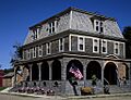
Carroll House Hotel
The Carroll House Hotel in Fullerton is another historic hotel building in the county.
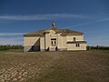
Divide County
Divide County has five historic places.
Divide County Courthouse
The Divide County Courthouse in Crosby is a historic building that has been on the Register since 1980.
Niels Nielsen Fourteen-Side Barn Farm
The Niels Nielsen Fourteen-Side Barn Farm near Noonan is a unique historic farm with a very unusual 14-sided barn!
Dunn County
Dunn County has four historic places.
Lynch Quarry Site
The Lynch Quarry Site near Dunn Center is a National Historic Landmark. It's an important archaeological site where ancient people mined flint for tools.
Eddy County
Eddy County has four historic places.
Eddy County Courthouse
The Eddy County Courthouse in New Rockford is a historic building that was listed in 1985.
Sylvanus Marriage Octagonal Barn
The Sylvanus Marriage Octagonal Barn near New Rockford is another example of a unique, multi-sided barn in North Dakota.
Emmons County
Emmons County has 17 historic places. You can find more details about them here: National Register of Historic Places listings in Emmons County, North Dakota.
Foster County
Foster County has six historic places.
Foster County Courthouse
The Foster County Courthouse in Carrington is a historic building that was added to the Register in 1980.
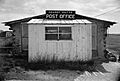
U.S. Post Office-Carrington
The U.S. Post Office in Carrington is also a historic building, listed in 1989.
Golden Valley County
Golden Valley County has two historic places.
Golden Valley County Courthouse
The Golden Valley County Courthouse in Beach is a historic building that was listed in 1985.
Grand Forks County
Grand Forks County has 67 historic places, making it one of the counties with the most listings. You can find more details about them here: National Register of Historic Places listings in Grand Forks County, North Dakota.
Grant County
Grant County has four historic places.
Carson Roller Mill
The Carson Roller Mill in Carson is a historic mill that was added to the Register in 1980.
Medicine Rock State Historic Site
The Medicine Rock State Historic Site near Heil is an important historical and cultural site.
Griggs County
Griggs County has four historic places.
Griggs County Courthouse
The Griggs County Courthouse in Cooperstown is a historic building listed in 1977.
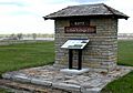
Oscar-Zero Missile Alert Facility
The Oscar-Zero Missile Alert Facility is a very interesting historic site north of Cooperstown. It was a missile launch control center for the U.S. Air Force during the Cold War.
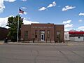
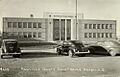
Hettinger County
Hettinger County has five historic places.
Hettinger County Courthouse
The Hettinger County Courthouse in Mott is a historic building that was listed in 1985.
Dr. S. W. Hill Drug Store
The Dr. S. W. Hill Drug Store in Regent is a historic building that tells a story about early businesses in the area.
Kidder County
Kidder County has three historic places.
Kidder County Courthouse
The Kidder County Courthouse in Steele is a historic building that was listed in 1985.
Crystal Springs Fountain
The Crystal Springs Fountain is a historic fountain near Crystal Springs, built during the 1930s.
LaMoure County
LaMoure County has two historic places.
La Moure County Courthouse
The La Moure County Courthouse in LaMoure is a historic building that was listed in 1980.
Logan County
Logan County has two historic places.
Logan County Courthouse
The Logan County Courthouse in Napoleon is a historic building that was listed in 1985.
McHenry County
McHenry County has 12 historic places. You can find more details about them here: National Register of Historic Places listings in McHenry County, North Dakota.
McIntosh County
McIntosh County has eight historic places.
McIntosh County Courthouse
The McIntosh County Courthouse in Ashley is a historic building that was listed in 1980.
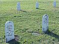
Ashley Jewish Homesteaders Cemetery
The Ashley Jewish Homesteaders Cemetery is a unique historic cemetery that tells the story of Jewish settlers in the area.
McKenzie County
McKenzie County has four historic places.
Fort Union Trading Post National Historic Site
The Fort Union Trading Post National Historic Site near Williston is a very important historic site. It was a major fur trading post in the 1800s, where different Native American tribes and fur traders met.
Fairview Lift Bridge
The Fairview Lift Bridge near Cartwright is a historic railroad bridge that could be lifted to let boats pass underneath.
McLean County
McLean County has seven historic places.
Former McLean County Courthouse
The Former McLean County Courthouse in Washburn is a historic building that was listed in 1985.
Holy Trinity Ukrainian Greek Orthodox Church
The Holy Trinity Ukrainian Greek Orthodox Church in Wilton is a beautiful historic church that was listed in 1982.
Mercer County
Mercer County has eight historic places.
Big Hidatsa Village Site
The Big Hidatsa Village Site near Stanton is a National Historic Landmark. It's an important archaeological site of a large Hidatsa Native American village.
Knife River Indian Villages National Historic Site
The Knife River Indian Villages National Historic Site near Stanton is another very important archaeological district. It preserves the remains of several Native American villages.
Morton County
Morton County has ten historic places. Many are in Mandan.
Huff Archeological Site
The Huff Archeological Site near Huff is a National Historic Landmark. It's a significant archaeological site of a fortified Mandan Native American village.
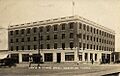
Lewis and Clark Hotel
The Lewis and Clark Hotel in Mandan is a historic hotel building that was listed in 1983.
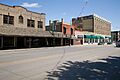
Mandan Commercial Historic District
The Mandan Commercial Historic District includes a group of historic buildings in downtown Mandan, showing what the city looked like long ago.
Mountrail County
Mountrail County has three historic places.
Mountrail County Courthouse
The Mountrail County Courthouse in Stanley is a historic building that was listed in 1978.
Nelson County
Nelson County has three historic places.
Tofthagen Library Museum
The Tofthagen Library Museum in Lakota is a historic building that serves as a library and museum.
Oliver County
Oliver County has one historic place.
Cross Ranch Archeological District
The Cross Ranch Archeological District in Hensler is a large historic area within the Cross Ranch Nature Preserve. It contains many archaeological sites.
Pembina County
Pembina County has 11 historic places. You can find more details about them here: National Register of Historic Places listings in Pembina County, North Dakota.
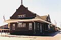
Pierce County
Pierce County has seven historic places.
Great Northern Passenger Depot
The Great Northern Passenger Depot in Rugby is a historic train station. It was listed in 1991.
Pierce County Courthouse
The Pierce County Courthouse in Rugby is a historic building that was listed in 1980.
Ramsey County
Ramsey County has 14 historic places. You can find more details about them here: National Register of Historic Places listings in Ramsey County, North Dakota.
Ransom County
Ransom County has nine historic places.
Biesterfeldt Site
The Biesterfeldt Site near Lisbon is a National Historic Landmark. It's an important archaeological site of a Cheyenne Native American village.
Ransom County Courthouse
The Ransom County Courthouse in Lisbon is a historic building that was listed in 1985.
Renville County
Renville County has two historic places.
Renville County Courthouse
The Renville County Courthouse in Mohall is a historic building that was listed in 1985.
Richland County
Richland County has 12 historic places. You can find more details about them here: National Register of Historic Places listings in Richland County, North Dakota.
Rolette County
Rolette County has three historic places.
Coghlan Castle
The Coghlan Castle near St. John is a unique historic building that looks like a castle! It was listed in 2008.
Sargent County
Sargent County has one historic place.
Sargent County Courthouse
The Sargent County Courthouse in Forman is a historic building that was listed in 1980.
Sheridan County
Sheridan County has two historic places.
Sheridan County Courthouse
The Sheridan County Courthouse in McClusky is a historic building that was listed in 1985.
Sioux County
Sioux County does not currently have any active listings on the National Register of Historic Places.
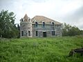
Slope County
Slope County has two historic places.
Mystic Theatre
The Mystic Theatre in Marmarth is a historic movie theater that was listed in 1977.
Stark County
Stark County has five historic places.
Dickinson (Carnegie Area) Public Library
The Dickinson Public Library is a historic library building in Dickinson. It was built with money from Andrew Carnegie.
Dickinson State Normal School Campus District
This historic district includes several buildings on the campus of what is now Dickinson State University.
Stark County Courthouse
The Stark County Courthouse in Dickinson is a historic building that was listed in 1985.
Steele County
Steele County has three historic places.
Baldwin's Arcade
Baldwin's Arcade in Hope is a historic building that was listed in 1975.
Steele County Courthouse
The Steele County Courthouse in Finley is a historic building that was listed in 1985.
Stutsman County
Stutsman County has 11 historic places. You can find more details about them here: National Register of Historic Places listings in Stutsman County, North Dakota.
Towner County
Towner County has one historic place.
Towner County Courthouse
The Towner County Courthouse in Cando is a historic building that was listed in 1985.
Traill County
Traill County has 22 historic places. You can find more details about them here: National Register of Historic Places listings in Traill County, North Dakota.
Walsh County
Walsh County has 15 historic places. You can find more details about them here: National Register of Historic Places listings in Walsh County, North Dakota.
Ward County
Ward County has 15 historic places. You can find more details about them here: National Register of Historic Places listings in Ward County, North Dakota.
Wells County
Wells County has five historic places.
Wells County Courthouse
The Wells County Courthouse in Fessenden is a historic building that was listed in 1977.
Wells County Fairgrounds
The Wells County Fairgrounds in Fessenden is a historic area where the county fair has been held for many years.
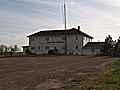
Williams County
Williams County has eight historic places.
Fort Buford State Historic Site
Fort Buford is a historic fort southwest of Williston, located where the Yellowstone and Missouri Rivers meet. It played an important role in the history of the American West.
James Memorial Library
The James Memorial Library in Williston is a historic library building that was listed in 1979.
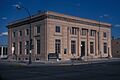
Old U.S. Post Office
The Old U.S. Post Office in Williston is another historic building that served the community for many years.
Images for kids
-
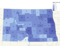
Map showing historic places in North Dakota
-

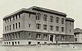
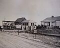
The Grand Forks Herald building after a flood
-
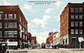
A view of the Downtown Grand Forks Historic District around 1912
-
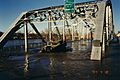
A car on the Sorlie Memorial Bridge
-
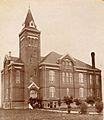
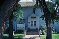
The Adams County Courthouse in Hettinger
-
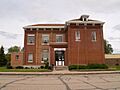
The Benson County Courthouse in Minnewaukan
-
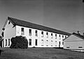
Barracks at Fort Totten State Historic Site
-
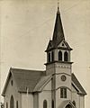
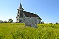
Viking Lutheran Church near Maddock
-
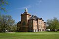
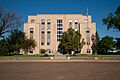
The Billings County Courthouse in Medora
-
Chateau de Mores in Medora
-
Ruins of the De Mores Packing Plant
-
The ranch house at Peaceful Valley Ranch
-

St. Mary's Catholic Church in Medora
-
The Von Hoffman House in Medora
-
Old Main at the North Dakota School of Forestry
-
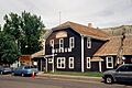
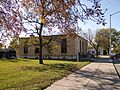
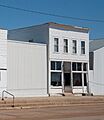
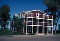
The former State Bank of Antler
-
The Roxy Theatre in Langdon
-
The Carroll House Hotel in Fullerton
-
The Dickey County Courthouse in Ellendale
-

The Opera Block in Ellendale
-

The Klein and Sutmar Block in Oakes
-
The Oakes National Bank Block in Oakes
-
The Oakes Post Office
-

White Stone Hill in Dickey County
-
Alkabo School in Divide County
-
The Divide County Courthouse in Crosby
-
The Niels Nielsen Fourteen-Side Barn Farm
-
The Travelers Hotel in Noonan
-
Lynch Knife River Flint Quarry
-
Saints Peter and Paul Church in New Hradec
-
The Eddy County Courthouse in New Rockford
-
The New Rockford Post Office
-
The Foster County Courthouse in Carrington
-
The Carrington Post Office
-
The Golden Valley County Courthouse in Beach
-
The Carson Roller Mill in Carson
-
Evangelisch Lutheraner Dreieinigkeit Gemeinde
-
The Griggs County Courthouse in Cooperstown
-

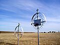
Launch control center at Oscar-Zero Missile Alert Facility
-
The Romness Bridge
-
The Hettinger County Courthouse in Mott
-
Dr. S. W. Hill Drug Store in Regent
-
Neuburg Congregational Church
-
Riverside in New England
-

Crystal Springs Fountain
-
The Kidder County Courthouse in Steele
-
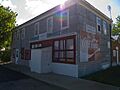
Dagen's Grocery in Jud
-
The La Moure County Courthouse in LaMoure
-
The McIntosh County Courthouse in Ashley
-

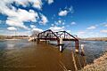
The Fairview Lift Bridge
-
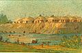
Fort Union Trading Post National Historic Site
-
The Grassy Butte Post Office
-
The former McLean County Courthouse in Washburn
-

Holy Trinity Ukrainian Greek Orthodox Church in Wilton
-
Soo Line Depot in Wilton
-
Wrought-iron crosses at Zion Lutheran Cemetery
-
Big Hidatsa Village Site
-
Fort Clark Archeological District
-

Knife River Indian Villages National Historic Site
-

Hotel Brown in Flasher
-
Huff State Historic Site
-
The Lewis and Clark Hotel in Mandan
-
Mandan Commercial Historic District
-
The Mountrail County Courthouse in Stanley
-
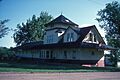
The Great Northern Passenger Depot in Rugby
-

Old Mt. Carmel Cemetery
-
The Pierce County Courthouse in Rugby
-

St. Anselm's Cemetery
-

The Rugby Post Office
-
The Bradford Hotel in Lisbon
-
The Ransom County Courthouse in Lisbon
-
The Lisbon Post Office
-
The Renville County Courthouse in Mohall
-
Coghlan Castle
-
U.S. Inspection Station-St. John
-

The Sargent County Courthouse in Forman
-
The Sheridan County Courthouse in McClusky
-

The former Sioux County Courthouse
-
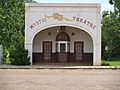
The Mystic Theatre in Marmarth
-
The former Slope County Courthouse
-
The Stark County Courthouse in Dickinson
-
Dickinson State Normal School Campus District
-

Baldwin's Arcade in Hope
-
The Steele County Courthouse in Finley
-
The Towner County Courthouse in Cando
-
Vang Evangelical Lutheran Church in Manfred
-
The Wells County Courthouse in Fessenden
-
Fort Buford State Historic Site
-

The James Memorial Library in Williston
-
The Old Armory in Williston
-
The Old U.S. Post Office in Williston
-
The Ray Opera House in Ray


.jpg)


.jpg)


.jpg)
.jpg)
.jpg)
.jpg)


.jpg)


.jpg)


.jpg)


.jpg)


.jpg)


.jpg)


