
National Register of Historic Places listings in Richland County, North Dakota facts for kids

Hey there! Did you know that some buildings and places are so special that they get a spot on a super important list? This list is called the National Register of Historic Places. It's like a hall of fame for historic sites across the United States. In Richland County, North Dakota, there are 12 amazing places that have made it onto this list! These places are important because they tell us stories about the past and help us understand how things used to be.
| Adams | Barnes | Benson | Billings | Bottineau | Bowman | Burke | Burleigh | Cass | Cavalier | Dickey | Divide | Dunn | Eddy | Emmons | Foster | Golden Valley | Grand Forks | Grant | Griggs | Hettinger | Kidder | La Moure | Logan | McHenry | McIntosh | McKenzie | McLean | Mercer | Morton | Mountrail | Nelson | Oliver | Pembina | Pierce | Ramsey | Ransom | Renville | Richland | Rolette | Sargent | Sheridan | Sioux | Slope | Stark | Steele | Stutsman | Towner | Traill | Walsh | Ward | Wells | Williams |
Cool Historic Places in Richland County
Let's take a look at some of the cool historic spots you can find in Richland County. Each one has its own unique story!
Historic Farms and Their Stories
Richland County is known for its farming history, and some of its most famous historic places are old farms.
Adams-Fairview Bonanza Farm
The Adams-Fairview Bonanza Farm is located near Wahpeton, North Dakota. It was added to the National Register in 1990. "Bonanza farms" were huge farms that operated like big businesses, especially in the late 1800s. They were very important for growing wheat in this region.
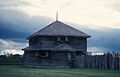
Frederick A. and Sophia Bagg Bonanza Farm
Another incredible bonanza farm is the Frederick A. and Sophia Bagg Bonanza Farm, found near Mooreton, North Dakota. This farm became a National Historic Landmark in 1985, which means it's extra special and important to the whole country! It shows us how farming changed and grew in North Dakota a long time ago.

Fort Abercrombie: A Military Past

Near Abercrombie, North Dakota, you'll find Fort Abercrombie. This fort was built in 1858 and was the very first permanent military settlement in what would become North Dakota! Imagine soldiers living here long ago, protecting settlers and trade routes. It was added to the National Register in 2009.
Important Buildings in Wahpeton
Wahpeton, North Dakota has several buildings on the National Register, showing its rich history as a city.
Leach Public Library
The Leach Public Library, located at 417 2nd Ave. N., is a beautiful building that became historic in 1990. Libraries are super important places for learning and community, and this one has been serving Wahpeton for many years.

Red River Valley University
The Red River Valley University building on N. 6th St. was listed in 1984. Even if it's not a university anymore, its history reminds us of the importance of education in the area.
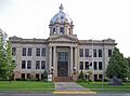
Richland County Courthouse
The Richland County Courthouse, located off ND 13, is where important local government decisions are made. This impressive building was added to the National Register in 1980.

Wahpeton Post Office
The US Post Office in Wahpeton, at 620 Dakota Ave., is another historic spot, listed in 1989. Post offices were, and still are, vital for connecting people through mail.

Wahpeton Hospital
The Wahpeton Hospital, located at 720-722 Dakota Ave., was recognized as historic in 1983. Hospitals are crucial for a community's health, and this building represents a long history of care.
Historic Spots in Christine
The small town of Christine, North Dakota also has two interesting places on the list.
Nelson's Grocery
Nelson's Grocery, at Main and 3rd Sts., was listed in 1977. Imagine a time when this was the main place to get your food and supplies!

Christine Post Office
Right next to Nelson's Grocery, at Main and 3rd Sts., is the historic Post Office in Christine. It was also added to the National Register in 1977.
.jpg)
Churches with History
Churches often play a big role in a community's history and culture.
South Wild Rice Church
The South Wild Rice Church is located southeast of Galchutt, North Dakota, at US Route 81 and County Road 8. This church was listed in 1982 and has been a spiritual center for its community for many years.
St. Alban's Episcopal Church
In Lidgerwood, North Dakota, you can find St. Alban's Episcopal Church at the corner of Hammond and Eastern Aves. It was added to the National Register in 1992, showing its importance to the town's heritage.
Images for kids
-
Fort Abercrombie, the first permanent military post in North Dakota.
-

The main house at the Frederick A. and Sophia Bagg Bonanza Farm.
-

The historic Leach Public Library in Wahpeton.
-

A view of Christine, North Dakota, showing Nelson's Grocery.
-

The historic Post Office in Christine.
-
The Richland County Courthouse.
-

The historic Wahpeton Post Office.
