National Register of Historic Places listings in Ottawa County, Ohio facts for kids
Have you ever wondered about the oldest and most important buildings and places in your area? In Ottawa County, Ohio, there's a special list of historic spots called the National Register of Historic Places. This list helps protect buildings, sites, and objects that are important to the history of the United States. Think of it like a hall of fame for historic places!
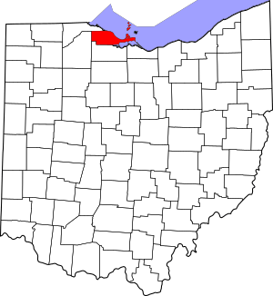
When a place is added to this list, it means it's recognized for its unique history, architecture, or connection to important events. This helps people understand and appreciate the past. In Ottawa County, there are 31 places on this list, including two extra-special ones called National Historic Landmarks. These landmarks are considered to be of national importance, meaning they tell a big story about American history.
Contents
What is the National Register of Historic Places?
The National Register of Historic Places is the official list of the nation's historic places worth saving. It's managed by the National Park Service, which is part of the U.S. government. When a building or site is listed, it gets special recognition and can sometimes get help for preservation. This means keeping it safe and looking good for future generations.
Why are these places important?
These historic places are like time capsules. They show us how people lived, worked, and built things long ago. They can be old houses, churches, lighthouses, or even battlefields. Each one has a story to tell about Ottawa County and Ohio's past.
Famous Historic Places in Ottawa County
Ottawa County is home to some truly amazing historic sites. Let's explore a few that stand out!
Jay Cooke House: A Historic Island Home
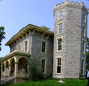
One of the most famous spots is the Jay Cooke House, also known as Cooke Castle. It's located on Gibraltar Island in Lake Erie, near Put-in-Bay, Ohio. This house was built by Jay Cooke, a very important banker during the American Civil War. He helped the U.S. government raise money for the war. The house became a National Historic Landmark in 1966. Imagine living in a castle on your own island!
Johnson's Island Civil War Prison: A Look Back at the Civil War
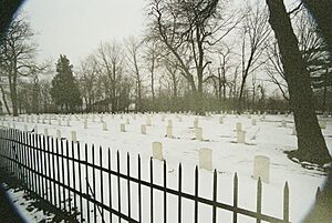
Another National Historic Landmark in Ottawa County is the Johnson Island Civil War Prison and Fort Site. This island, located in Danbury Township, was a prison camp for Confederate officers during the Civil War. It's a powerful reminder of that difficult time in American history. Exploring this site helps us understand the challenges faced by soldiers and prisoners.
Marblehead Lighthouse: Guiding Ships for Centuries
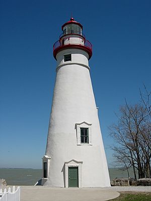
The Marblehead Lighthouse is one of the most iconic landmarks in Ohio. Located in Marblehead, Ohio, it's the oldest continuously operating lighthouse on the Great Lakes. It has been guiding ships safely through the waters of Lake Erie since 1822! It's a beautiful spot to visit and learn about maritime history.
Perry's Victory and International Peace Memorial: A Monument to Peace
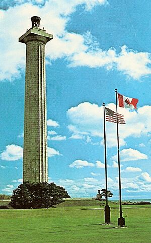
On South Bass Island in Put-in-Bay, Ohio, stands the towering Perry's Victory and International Peace Memorial. This huge monument celebrates the Battle of Lake Erie during the War of 1812. It also honors the lasting peace between the United States, Great Britain, and Canada. It's a powerful symbol of how conflicts can end in friendship.
Other Notable Historic Places
Beyond the landmarks, many other places in Ottawa County have special historical value.
Old Buildings with New Stories
- The Carroll Township Hall is an example of a local government building that has served its community for many years.
- The Catawba Island Wine Company shows the history of winemaking in the region.
- The First Congregational Church in Marblehead is a beautiful example of historic religious architecture.
- The Genoa Town Hall and Port Clinton City Hall are important civic buildings.
- The Island House in Port Clinton is a historic hotel that has welcomed visitors for a long time.
Historic Homes and Farms
Many old homes are also on the list, like the Charles Andres House on Middle Bass Island, the Alexander Clemons House in Marblehead, and the Foster-Gram House on South Bass Island. These homes give us a glimpse into the daily lives of people from the past. The Benajah Wolcott House is another interesting example of an early settler's home.
Bridges and Lighthouses
Besides Marblehead, the Green Island Light is another historic lighthouse in Lake Erie, helping ships navigate. The South Bass Island Light also stands as a guardian of the waters. Even bridges, like the Ohio State Route 51 Bridge over the Portage River, can be historic because of their engineering or age.
Historic Districts
Some areas are listed as "historic districts" because they have many important buildings together. The Lakeside Historic District in Danbury Township is a great example of a community that has kept its historic charm. The Main Street Historic District in Genoa and the Middle Bass Club Historic District also preserve the look and feel of earlier times.
Images for kids


