
National Register of Historic Places listings in Pike County, Illinois facts for kids

Welcome to Pike County, Illinois! This area is full of amazing history, and many of its special places are listed on the National Register of Historic Places. This list helps protect important buildings, sites, and districts across the United States. It's like a special hall of fame for places that tell a part of America's story.
In Pike County, there are 14 different places that have earned a spot on this important list. One of them is even a National Historic Landmark, which is an even higher honor! These places are spread out across the county, from small towns to quiet countryside spots. Let's explore some of these cool historic locations!
Contents
- What is the National Register of Historic Places?
- Historic Places in Pike County
- Barry Historic District
- Church of Christ (Perry, Illinois)
- Griggsville Historic District
- Griggsville Landing Lime Kiln
- Lock and Dam No. 22 Historic District
- Massie Variety Store
- Free Frank McWorter Grave Site
- Naples Mound 8
- New Philadelphia Town Site
- Pittsfield East School
- Pittsfield Historic District
- Lyman Scott House
- John Shastid House
- Zoe Theatre
- Images for kids
What is the National Register of Historic Places?
The National Register of Historic Places is the official list of the nation's historic places worthy of preservation. It's managed by the National Park Service. When a place is added to the Register, it means it's recognized for its importance in American history, architecture, archaeology, engineering, or culture. This recognition can help protect the place and sometimes even provide funds for its care.
Why are places added to the Register?
Places get added to the National Register for many reasons. They might be:
- Where important events happened.
- Homes of famous people.
- Great examples of certain types of architecture.
- Places that show how people lived long ago.
- Sites with important archaeological finds.
Historic Places in Pike County
Pike County has a rich history, and its historic places reflect different times and stories. From old towns to unique buildings, each spot has something interesting to share.
Barry Historic District

The Barry Historic District is located in the town of Barry. This district includes many buildings along U.S. Route 36. It was added to the National Register on March 13, 1979. Historic districts are areas with many buildings that together tell a story about the past. Walking through Barry's historic district is like taking a step back in time!
Church of Christ (Perry, Illinois)
In the town of Perry, you'll find the Church of Christ at 102 Main Street. This church building was recognized for its historical value on August 8, 2006. Churches often play a big role in a community's history, serving as gathering places for many years.
Griggsville Historic District

The Griggsville Historic District is in Griggsville. This district covers an area with an interesting pattern of streets, including Corey, Stanford, Quincy, and Liberty Streets. It was added to the National Register on January 17, 1979. Like Barry, Griggsville's district helps preserve the look and feel of an older American town.
Griggsville Landing Lime Kiln
North of Napoleon Hollow, near Valley City, is the Griggsville Landing Lime Kiln. This old structure was used to make lime, which was important for building and farming long ago. It was listed on August 30, 1999, showing its importance to the area's industrial past.
Lock and Dam No. 22 Historic District
Near Hull, you'll find the Lock and Dam No. 22 Historic District. This district includes parts of Road 920E and even extends into Ralls County, Missouri. It was added on March 10, 2004. Locks and dams are important structures that help boats travel along rivers and control water levels. This one tells a story about transportation and engineering.
Massie Variety Store
The Massie Variety Store is located at 110 South Main Street in New Canton. This store was added to the National Register on August 20, 2004. Old general stores or variety stores were often the heart of small towns, where people could buy almost anything they needed.
Free Frank McWorter Grave Site
About 4 miles east of Barry, off U.S. Route 36, is the Free Frank McWorter Grave Site. This site is very important because it honors Free Frank McWorter, an amazing person who bought his freedom and founded the town of New Philadelphia. His grave site was listed on April 19, 1988, recognizing his incredible achievements.
Naples Mound 8

North of Interstate 72, just west of the Illinois River, you can find Naples Mound 8 near Griggsville. This ancient mound was built by early Native American people. It was listed on October 14, 1975, and is a key archaeological site that helps us understand the history of the first people in this area.
New Philadelphia Town Site

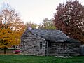
The New Philadelphia Town Site is east of Barry, on Township Road 156. This site is incredibly special because it was the first town in the United States founded by an African American man, Free Frank McWorter. It was listed on August 11, 2005, and later became a National Historic Landmark on January 16, 2009. This makes it one of the most important historic places in the entire country!
Pittsfield East School
The Pittsfield East School is located at 400 East Jefferson Street in Pittsfield. This old school building was added to the National Register on February 12, 1971. School buildings often hold many memories and represent the importance of education in a community's past.
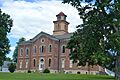
Pittsfield Historic District

Also in Pittsfield is the Pittsfield Historic District. This district is roughly bounded by Washington Court and Sycamore, Morrison, and Griggsville Streets. It was listed on June 4, 1980. This district helps preserve the historic heart of Pittsfield, including many important buildings.
Lyman Scott House
The Lyman Scott House is on U.S. Route 54 near Summer Hill. This historic home was added to the National Register on February 10, 1983. Old houses like this often show us how people lived and what kind of architecture was popular in the past.
John Shastid House
.jpg)
Another historic home in Pittsfield is the John Shastid House at 326 East Jefferson. It was listed on June 26, 2003. Each historic house has its own story, and this one adds to the rich history of Pittsfield.
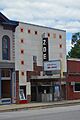
Zoe Theatre

Finally, the Zoe Theatre is located at 209 North Madison Street in Pittsfield. This historic theater was added to the National Register on January 2, 2013. Old movie theaters are special places that bring back memories of entertainment and community gatherings from long ago.
Images for kids
-
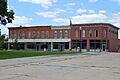
The public square in Barry, part of its historic district.
-
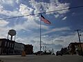
A view of Griggsville, part of its historic district.
-
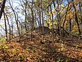
Naples Mound 8, an ancient burial mound.
-

The New Philadelphia townsite, a National Historic Landmark.
-
Pittsfield East School.
-

The courthouse in Pittsfield, part of its historic district.
-
The back of the John Shastid House in Pittsfield.
-
The front of the Zoe Theatre in Pittsfield.

