
National Register of Historic Places listings in Sanpete County, Utah facts for kids
The

Sanpete County in Utah is a special place with many old buildings and sites that are super important to history! These places are listed on something called the National Register of Historic Places. Think of it like a special hall of fame for buildings and areas that tell amazing stories about the past.
Sanpete County, along with its neighbor Sevier County, is sometimes called "Little Scandinavia." Why? Because in the 1800s, about 20,000 people from Scandinavian countries (like Denmark, Norway, and Sweden) came to Utah, and many of them settled right here! You can even find unique "pair-houses" in the area, which are a type of home design brought over by these Scandinavian settlers.
There are 81 different places in Sanpete County that are on this special list. One other place used to be on the list but was later removed. Let's explore some of these cool historic spots!
Contents
Historic Homes and Buildings
Many of the places on the National Register are old homes, each with its own story. These houses show us how people lived long ago and the different styles of buildings they created.
Homes with History
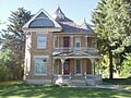
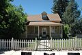
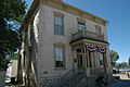
- Claus P. Andersen House in Ephraim: This house was added to the list in 1983. It's a great example of the homes built in the area.
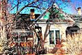
- James Anderson House in Fairview: Listed in 1980, this house gives us a peek into Fairview's past.
- Greaves-Deakin House in Ephraim: This historic home was added to the list in 1980.
- Hans A. Hansen House in Ephraim: Another Ephraim home, listed in 1980, showing the town's early architecture.
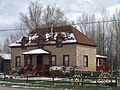
- Niels P. Hjort House in Fairview: This house, listed in 1980, is a historic landmark in Fairview.
- Johnson-Nielson House in Ephraim: This house, listed in 1982, is a significant part of Ephraim's history.
- Larsen-Noyes House in Ephraim: Added to the list in 1978, this house is found on Center Street.
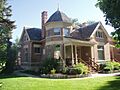
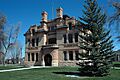
- Canute Peterson House in Ephraim: Listed in 1978, this house belonged to Canute Peterson, an important figure in Ephraim's early days.
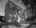
- Fredrick Christian Sorensen House in Ephraim: This Ephraim home was added to the list in 1980.
Other Notable Residences
- John Dorius, Jr. House in Ephraim: This house was listed in 1985.
- Cox-Shoemaker-Parry House in Manti: An important Manti home, listed in 1982.
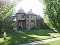
- James and Caroline M. Metcalf House in Gunnison: This house was added to the list in 1998.
- Oberg-Metcalf House in Gunnison: Another historic home in Gunnison, listed in 1997.
- Ezra and Abigail Shomaker House in Manti: This Manti home was added to the list in 2014.
Important Public Buildings
Sanpete County also has many public buildings that are historically important. These include schools, libraries, and government buildings that served the community for many years.
Libraries and City Halls
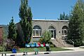
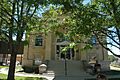
- Ephraim Carnegie Library in Ephraim: Built with money from Andrew Carnegie, this library was listed in 1984. Carnegie helped build many libraries across the U.S.!
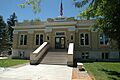
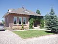
- Fairview City Hall in Fairview: This building, where local government happens, was listed in 1986.
- Manti Carnegie Library in Manti: Another Carnegie-funded library, this one in Manti was listed in 1984.
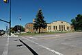
- Manti City Hall in Manti: The city hall for Manti was added to the list in 1985.
- Mount Pleasant Carnegie Library in Mount Pleasant: This library in Mount Pleasant was listed in 1984.
Schools and Community Centers
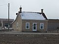
- Centerfield School and Meetinghouse in Centerfield: This building served as both a school and a meeting place and was listed in 2000.
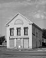
- Fairview Amusement Hall in Fairview: This hall, listed in 2002, was a place for fun and gatherings in Fairview.
- Snow Academy Building in Ephraim: This building is part of Snow College and was listed in 1987.
- Spring City School in Spring City: This historic school building was added to the list in 1978.
Unique Historic Districts and Sites
Some places are listed as "historic districts," which means a whole area or group of buildings is important together.
- Fountain Green Hydroelectric Plant Historic District in Fountain Green: This district, listed in 1989, includes the old power plant that used water to make electricity.
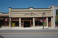
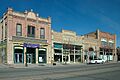
- Mount Pleasant Commercial Historic District in Mount Pleasant: This area, listed in 1979, includes many old shops and businesses that show what the town's main street looked like long ago.
- Spring City Historic District in Spring City: This entire district, listed in 1980, is known for its beautiful historic buildings and unique town layout. It's like stepping back in time!
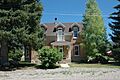
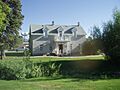
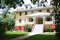
- Wasatch Academy in Mount Pleasant: This historic school campus was listed as a district in 1978.
Religious and Other Important Buildings
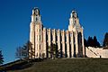
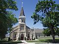
- Manti Temple in Manti: This beautiful temple, a very important building for members of The Church of Jesus Christ of Latter-day Saints, was listed in 1971. It's a landmark in the area.
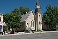
- Manti Presbyterian Church in Manti: This church building was added to the list in 1980.
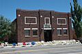
- Ephraim United Order Cooperative Building in Ephraim: This building, listed in 1973, was part of a cooperative effort in the early days of Ephraim.
- Casino Theatre in Gunnison: This old theater, listed in 1989, was a place where people watched movies and shows.
- Manti Motor Company Building in Manti: This building, listed in 2008, was once a place where cars were sold or repaired.
- Moroni Opera House in Moroni: This opera house, listed in 1996, was a center for entertainment in Moroni.
Former Listing
Sometimes, a place might be removed from the National Register if it changes too much or is no longer considered historically important.
- George Washington Bradley House in Moroni: This house was listed in 1980 but was later removed from the list in 1983.
Images for kids
-
The Claus P. Andersen House in Ephraim.
-
The James Anderson House in Fairview.
-
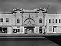
The Casino Theatre in Gunnison.
-
The Centerfield School and Meetinghouse.
-
The John Dorius, Jr. House in Ephraim.
-
The Ephraim Carnegie Library.
-
The Ephraim United Order Cooperative Building.
-
The Fairview Amusement Hall.
-
The Fairview City Hall.
-
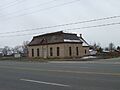
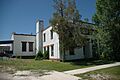
The Fairview Tithing Office/Bishop's Storehouse.
-
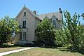
The Greaves-Deakin House in Ephraim.
-
The Hans A. Hansen House in Ephraim.
-
The Niels P. Hjort House in Fairview.
-
The Johnson-Nielson House in Ephraim.
-
The Larsen-Noyes House in Ephraim.
-
The Manti Carnegie Library.
-
The Manti City Hall.
-
The Manti Motor Company Building.
-
The Manti National Guard Armory.
-
The Manti Presbyterian Church.
-
The Manti Temple.
-
The James and Caroline M. Metcalf House in Gunnison.
-
The Mount Pleasant Carnegie Library.
-
A view of the Mount Pleasant Commercial Historic District.
-
The Mount Pleasant National Guard Armory.
-
The Oberg-Metcalf House in Gunnison.
-
The Canute Peterson House in Ephraim.
-
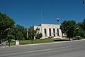
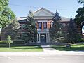
The Sanpete County Courthouse in Manti.
-
The Snow Academy Building in Ephraim.
-

The Fredrick Christian Sorensen House in Ephraim.
-
A building within the Spring City Historic District.
-
The Spring City School.
-
Finks Dormitory at Wasatch Academy in Mount Pleasant.


