Mount Pleasant, Utah facts for kids
Quick facts for kids
Mount Pleasant, Utah
|
|
|---|---|

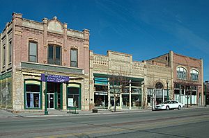
Historic buildings on Mount Pleasant's Main Street
|
|

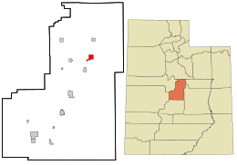
Location in Sanpete County and the state of Utah.
|
|
| Country | |
| State | |
| County | Sanpete |
| Incorporated | 1868 |
| Founded by | Madison Hambleton |
| Area | |
| • Total | 2.93 sq mi (7.59 km2) |
| • Land | 2.93 sq mi (7.59 km2) |
| • Water | 0.00 sq mi (0.00 km2) |
| Elevation | 5,925 ft (1,806 m) |
| Population
(2020)
|
|
| • Total | 3,655 |
| • Estimate
(2019)
|
3,530 |
| • Density | 1,204.78/sq mi (465.11/km2) |
| Time zone | UTC-7 (Mountain (MST)) |
| • Summer (DST) | UTC-6 (MDT) |
| ZIP code |
84647
|
| Area code(s) | 435 |
| FIPS code | 49-53010 |
| GNIS feature ID | 1430522 |
| Website | Mount Pleasant City Website |
Mount Pleasant is a city in the U.S. state of Utah. It is located in Sanpete County. Mount Pleasant is known for being home to Wasatch Academy, a private boarding school. In 2020, the city had a population of 3,655 people.
Contents
History of Mount Pleasant
In the spring of 1852, a group of settlers from Manti started a small community. This group was led by Madison D. Hambleton. They called their new home the Hambleton Settlement.
Early Challenges and Growth
During a conflict known as the Wakara War, the settlers had to move for safety. They went to nearby Spring Town (Spring City) and then to Manti. Native Americans later burned down the original settlement. In 1859, a larger group of settlers returned to the area. They laid out the permanent town where Mount Pleasant stands today.
Many of the first settlers were immigrants from places like Scandinavia and the United Kingdom. By 1880, Mount Pleasant was the largest city in Sanpete County. It had about 2,000 people. Over 72% of the adults were born in other countries. Because of this, five different languages were often spoken in the town for many years.
Town Layout and Development
Mount Pleasant was planned like many early Latter-Day Saint towns. A square-shaped town site was measured out. People then drew lots to get their land. A fort was built with adobe walls and log cabins. Pleasant Creek ran through the fort, and farming happened outside its walls.
James Russell Ivie, one of the leaders, was killed during the Ute Black Hawk War. Around that time, the town got its current name, Mount Pleasant. In 1872, a peace treaty was signed in a house on Main Street. This ended the conflict with the Native Americans. By then, many settlers had built homes outside the fort. The town was designed with lots of space, so even today, it doesn't feel too crowded.
Modern Improvements and Prosperity
Early jobs in Mount Pleasant included tanning animal hides and making shoes. People also worked as blacksmiths, basket makers, and freight haulers. Over time, the town became more modern. The Deseret Telegraph arrived in 1869, allowing faster communication. A newspaper called the Pyramid started in 1890, and a telephone system came in 1891.
Sawmills and flour mills were built to process wood and grain. Irrigation systems were dug to bring water to farms. The city officially became a city in 1868. This was a year after the first cooperative store opened. When the Rio Grande Western Railway arrived in 1890, the city grew even more. Its wealth also increased a lot. By 1900, Mount Pleasant had almost 3,000 people. It was the biggest city in Sanpete County at that time. This led to one of its nicknames, "Hub City."
The city's new wealth meant that old wooden buildings were replaced. Stronger stone and brick structures were built. An example is the Sanpete County Co-op, built in 1888. Also, simple adobe and log homes were replaced with fancier Victorian-style buildings. These included churches, schools, and houses.
Key Buildings and Services
By 1912, the first high school, North Sanpete High School, was finished. The Armory Hall was also built in 1912. The Elite Theater, designed to be "fireproof," was built in 1913. However, it burned down many decades later. In 1917, a Carnegie Library was built in a modern style.
The Marie Hotel was built in 1920. A large cheese factory opened in 1930. That same year, bus service came to town. The completion of U.S. Highway 89 in 1936 helped the city during the Great Depression. A city hall was built in 1939, and a hospital opened in 1945.
Geography
Mount Pleasant covers an area of about 2.8 square miles (7.3 km2).
Climate
The weather in Mount Pleasant changes a lot with the seasons. Summers are warm and dry. Winters are cold, sometimes very cold. This type of weather is called a warm summer continental climate.
Population Information
| Historical population | |||
|---|---|---|---|
| Census | Pop. | %± | |
| 1860 | 746 | — | |
| 1870 | 1,346 | 80.4% | |
| 1880 | 2,004 | 48.9% | |
| 1890 | 2,254 | 12.5% | |
| 1900 | 2,372 | 5.2% | |
| 1910 | 2,280 | −3.9% | |
| 1920 | 2,418 | 6.1% | |
| 1930 | 2,284 | −5.5% | |
| 1940 | 2,382 | 4.3% | |
| 1950 | 2,030 | −14.8% | |
| 1960 | 1,572 | −22.6% | |
| 1970 | 1,516 | −3.6% | |
| 1980 | 2,049 | 35.2% | |
| 1990 | 2,092 | 2.1% | |
| 2000 | 2,707 | 29.4% | |
| 2010 | 3,260 | 20.4% | |
| 2020 | 3,655 | 12.1% | |
| U.S. Decennial Census | |||
In 2000, there were 2,707 people living in Mount Pleasant. The population density was about 958 people per square mile. Most of the people were White (96.45%). About 2.66% of the population identified as Hispanic or Latino.
Many households (40.7%) had children under 18 living with them. The average household had about 3 people. The average family had about 3.5 people. The population was spread out by age. About 36.5% were under 18. About 13.8% were 65 or older. The average age was 30 years old.
Arts and Culture
Annual Cultural Events
- Hub City Days and the Fourth of July Celebration are big events. They include a parade down the main street. There's also a breakfast at the city park. A carnival and a rodeo with local cowboys are part of the fun. Fireworks follow the rodeo.
- Mount Pleasant Pioneer Day is held on the last Saturday in March. This day celebrates the city's early settlers.
Education
Mount Pleasant is part of the North Sanpete School District. The city has one elementary school. It is also home to North Sanpete High School, which is the only high school in the district. The district's middle school is in Moroni. Mount Pleasant is also where Wasatch Academy is located. This is a private boarding school that started in 1875.
Notable People
- Spencer Cox is the 18th Governor of Utah. He was also the 8th Lieutenant Governor of Utah.
- Leonard B. Jordan was the 23rd Governor of Idaho. He also served as a United States Senator from Idaho. He was born in Mount Pleasant.
- Mike Lookinland is an actor.
- Cyrus H. Wheelock wrote the famous Latter-Day Saint hymn "Ye Elders of Israel."
See also
 In Spanish: Mount Pleasant (Utah) para niños
 | Leon Lynch |
 | Milton P. Webster |
 | Ferdinand Smith |


