
National Register of Historic Places listings in Sequoia-Kings Canyon National Parks facts for kids
The Sequoia National Park and Kings Canyon National Park in California, United States, are home to many special places. Some of these places are so important that they are listed on the National Register of Historic Places. This is like a special list of buildings, sites, and objects that are important to American history and culture.
When a place is on this list, it means it's worth protecting and remembering for future generations. In these two national parks, there are 23 such places! They include old cabins, ranger stations, bridges, and even natural spots that tell a story about the past. Let's explore some of these amazing historic sites.
Contents
Historic Places in the Parks
Entrance Signs and Ranger Stations
Many of the historic places in the parks are buildings or structures that helped people explore and manage these wild areas long ago.
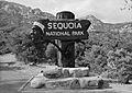
Ash Mountain Entrance Sign

The Ash Mountain Entrance Sign is one of the first things you see when entering Sequoia National Park from the south. It was put on the National Register in 1978. This sign isn't just a sign; it's a piece of history that has welcomed countless visitors to the park for many years. It reminds us of the early days of national parks.
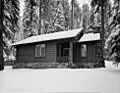
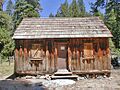
Cabin Creek Ranger Residence and Dormitory

Near Wilsonia, California, you'll find the Cabin Creek Ranger Residence and Dormitory. This building, listed in 1978, was where park rangers lived and worked. Rangers are super important for protecting the parks and helping visitors. This residence shows how park staff lived and managed the park in earlier times.
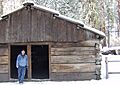
Hockett Meadow Ranger Station

Deep in Sequoia National Park, south of Silver City, California, is the Hockett Meadow Ranger Station. This station, added to the list in 1978, was a remote outpost for rangers. It helped them patrol and protect the more distant parts of the park, especially areas where cattle used to graze.
Quinn Ranger Station

Another important ranger outpost is the Quinn Ranger Station, located south of Mineral King. It was listed in 1977. These stations were vital for park operations, allowing rangers to live and work in the wilderness, keeping an eye on the land and helping visitors.
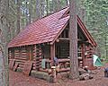
Redwood Meadow Ranger Station

The Redwood Meadow Ranger Station is found northeast of Three Rivers, California in Sequoia National Park. Listed in 1978, this station also played a key role in park management. It shows how rangers lived and worked in different parts of the vast park.
Historic Cabins and Shelters
Many old cabins and shelters in the parks tell stories of early settlers, explorers, and park workers.
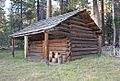
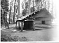
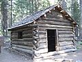
Barton-Lackey Cabin

In Kings Canyon National Park, near Cedar Grove, stands the Barton-Lackey Cabin. This cabin, listed in 1978, is a reminder of the early people who lived and worked in this rugged area before it became a national park.
Cattle Cabin

The Cattle Cabin is located northeast of Three Rivers, California in Sequoia National Park. Added to the list in 1977, this cabin was likely used by cattle ranchers who brought their herds to graze in the meadows of the Sierra Nevada mountains. It shows a different kind of history for the park.
Gamlin Cabin

Northwest of Wilsonia, California, you can find the Gamlin Cabin. This cabin, listed in 1977, is one of the oldest surviving structures in Kings Canyon National Park. It represents the early settlement and pioneer life in the region.
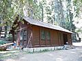
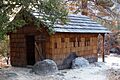
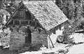
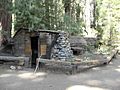
Knapp Cabin

The Knapp Cabin is located west of Cedar Grove in Kings Canyon National Park. It was listed in 1978. This cabin is another example of the simple, sturdy homes built by early residents in the remote mountain environment.
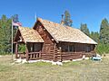
Shorty Lovelace Historic District

East of Pinehurst, California, in Kings Canyon National Park, is the Shorty Lovelace Historic District. This area, listed in 1978, includes the cabin and other features related to Shorty Lovelace, an early settler and miner in the region. It tells a story of self-sufficient living in the wilderness.
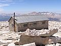
Smithsonian Institution Shelter

The Smithsonian Institution Shelter is located west of Lone Pine, California in Sequoia National Park. Listed in 1977, this shelter was built for scientific research and observation, especially related to Mount Whitney. It's a testament to early scientific exploration in the high Sierra.
Squatter's Cabin

Northeast of Three Rivers, California, you'll find Squatter's Cabin. This cabin, listed in 1977, is another example of the simple dwellings built by people living in the area before it became a protected park. It shows how people adapted to life in the mountains.
Tharp's Log

Also northeast of Three Rivers, California, is the very unique Tharp's Log. Listed in 1977, this isn't a typical cabin! It's a shelter built inside a hollowed-out fallen giant sequoia log. It was used by Hale Tharp, one of the first non-Native American settlers in the Giant Forest area. It's an amazing example of using natural materials for shelter.
Roads, Bridges, and Trails
The ways people traveled through the parks are also important parts of their history.
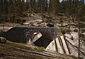
Generals' Highway Stone Bridges
.jpg)
The Generals' Highway Stone Bridges are located north of Mineral King in Sequoia National Park. These beautiful stone bridges, listed in 1978, are part of the famous Generals Highway. They were built with great care to blend into the natural landscape and are still used today. They show the skill of early park builders.
Mineral King Road Cultural Landscape

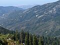
The Mineral King Road Cultural Landscape is the entire area around Mineral King Road in Sequoia National Park. This whole landscape, listed in 2003, is important because it shows how people have used and interacted with this part of the park over time, from mining to recreation.
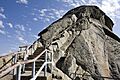
Moro Rock Stairway

North of Three Rivers, California in Sequoia National Park, you can climb the Moro Rock Stairway. This impressive stairway, listed in 1978, was built into the side of a huge granite dome. It allows visitors to safely reach the top for incredible views of the park. It's a great example of early park infrastructure designed for visitors.
Camps and Districts
Some larger areas, including groups of buildings or natural features, are also recognized for their historical importance.
Bearpaw Meadow High Sierra Camp

The Bearpaw Meadow High Sierra Camp is located in Sequoia National Park. Listed in 2016, this camp is part of a series of rustic camps along the High Sierra Trail. It has provided a place for hikers to rest and stay overnight for many years, allowing people to explore the park's backcountry.
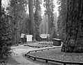
Giant Forest Lodge Historic District

Northeast of Three Rivers, California in Sequoia National Park, you'll find the Giant Forest Lodge Historic District. This area, listed in 1978, includes buildings and features related to the historic Giant Forest Lodge. It was a popular place for visitors to stay and enjoy the giant sequoia trees.
Giant Forest Village-Camp Kaweah Historic District

Just north of Three Rivers, California, the Giant Forest Village-Camp Kaweah Historic District was listed in 1978. This district includes various buildings and areas that supported visitors and park staff in the famous Giant Forest. It shows how the park developed facilities for tourism.
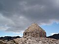
John Muir Memorial Shelter

The John Muir Memorial Shelter is located near General Grant Grove in Kings Canyon National Park. Listed in 1978, this stone shelter is named after the famous naturalist John Muir. It provides a safe haven for hikers in the high mountains, especially along the Pacific Crest Trail.
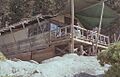
Pear Lake Ski Hut

North of Mineral King in Sequoia National Park is the Pear Lake Ski Hut. This hut, listed in 1978, is a special shelter used by cross-country skiers in the winter. It allows people to explore the snowy wilderness safely and is an important part of the park's winter recreation history.
Other Important Sites
Hospital Rock

Hospital Rock is a very important site near Three Rivers, California. Listed in 1977, this large rock has ancient pictographs (rock paintings) made by Native Americans who lived in the area long ago. It was also a stopping point for early explorers and settlers, and its name comes from its use as a place to care for sick or injured people.
These historic places help us understand the rich history of Sequoia and Kings Canyon National Parks, from the lives of early settlers and rangers to the ways people have explored and enjoyed these amazing natural wonders.
Images for kids
-
The historic Ash Mountain Entrance Sign welcomes visitors to Sequoia National Park.
-
The Barton-Lackey Cabin in Kings Canyon National Park.
-
Bearpaw Meadow High Sierra Camp, a historic stop for hikers.
-
The Cabin Creek Ranger Residence, a historic home for park rangers.
-
The Cattle Cabin, used by early ranchers.
-
The Gamlin Cabin, one of the oldest structures in the park.
-
One of the historic stone bridges on Generals Highway.
-
The Giant Forest Amphitheater, part of the historic lodge district.
-
A historic ranger residence in the Giant Forest Village.
-
The Hockett Meadow Ranger Station, a remote outpost in the park.
-
Hospital Rock, a site with ancient Native American pictographs.
-
Knapp Cabin, a historic dwelling in Kings Canyon.
-
The scenic Mineral King Road, a historic pathway.
-
The historic Moro Rock Stairway, leading to amazing views.
-
The John Muir Memorial Shelter, a stone refuge in the high mountains.
-
The Pear Lake Ski Hut, a winter refuge for skiers.
-
The Quinn Ranger Station, important for managing the park's wilderness.
-
The Redwood Meadow Ranger Station, nestled among the trees.
-
Shorty Lovelace Cabin, part of a historic district.
-
The Smithsonian Institution Shelter, a high-altitude refuge.
-
Squatter's Cabin, a simple home from the past.
-
Tharp's Log, a unique home inside a fallen giant sequoia.
