
National Register of Historic Places listings in Valdez–Cordova Census Area, Alaska facts for kids

This article is a list of special places in the Valdez-Cordova Census Area, Alaska, that are on the National Register of Historic Places. These places are important because they tell us about the history of Alaska and the United States.
The National Register of Historic Places is like a special club for buildings, sites, and objects that are important to American history. When a place is added to this list, it means it's recognized for its historical, architectural, or archaeological value. It helps protect these places for future generations to learn from and enjoy.
In the Valdez-Cordova Census Area, there are 28 places on this list. Three of these are even more special and are called National Historic Landmarks. One place that was on the list was later removed.
Contents
- Historic Places in Valdez-Cordova
- Bering Expedition Landing Site
- Bremner Historic Mining District
- Cape Hinchinbrook Light Station
- Cape St. Elias Lighthouse
- Chilkat Oil Company Refinery Site
- Chisana Historic Mining Landscape
- Chistochina Trading Post
- Chitina Tin Shop
- Copper River and Northwestern Railway
- Copper River and Northwestern Railway Bunkhouse and Messhouse
- Cordova Post Office and Courthouse
- Dakah De'nin's Village Site
- Gakona Historic District
- Gakona Roadhouse
- Kansky's
- Kennecott Mines
- McCarthy General Store
- McCarthy Power Plant
- Million Dollar Bridge
- Nabesna Gold Mine Historic District
- Palugvik Archeological District
- Pioneer Igloo Hall Number 19
- Reception Building
- Red Dragon Historic District
- St. Michael the Archangel Church
- Slana Roadhouse
- Tangle Lakes Archeological District
- Valdez Trail-Copper Bluff Segment
- Former Listing
Historic Places in Valdez-Cordova
This section shares some of the cool historic places you can find in the Valdez-Cordova area.
Bering Expedition Landing Site
The Bering Expedition Landing Site is located south of Katalla on Kayak Island. This spot is very important because it's where the famous explorer Vitus Bering and his crew landed in 1741. This was a big moment in the exploration of Alaska. It's recognized as a National Historic Landmark.

Bremner Historic Mining District
The Bremner Historic Mining District is found within the Wrangell–St. Elias National Park and Preserve. This area was once a busy gold mining camp. It shows what life was like for miners in the early 1900s. You can still see old buildings and equipment from that time.

Cape Hinchinbrook Light Station
The Cape Hinchinbrook Light Station is a lighthouse located on the southwestern tip of Hinchinbrook Island, near Cordova. Lighthouses are important because they guide ships safely through the water. This one has been helping sailors for many years.

Cape St. Elias Lighthouse
Another important lighthouse is the Cape St. Elias Lighthouse, also located south of Katalla on Kayak Island. This lighthouse has a tall, strong tower that stands against the wild Alaskan weather, helping ships navigate the coast.

Chilkat Oil Company Refinery Site
The Chilkat Oil Company Refinery Site is near Katalla. This site is historic because it was home to one of Alaska's first oil refineries. It shows the early days of the oil industry in the state.
Chisana Historic Mining Landscape
The Chisana Historic Mining Landscape is near the town of Chisana. This area was another important gold mining spot. It includes the old Chisana Airstrip and other features that tell the story of mining in this remote part of Alaska.

Chistochina Trading Post
The Chistochina Trading Post is located at the junction of the Glenn Highway and the Tok Cutoff, near Gakona. Trading posts were vital places where people could buy supplies and trade goods in the early days of Alaska. This one served travelers and locals for many years.
Chitina Tin Shop
The Chitina Tin Shop is on Main Street in Chitina. This building was once a workshop where tin items were made or repaired. It's a reminder of the crafts and businesses that supported early Alaskan communities.

Copper River and Northwestern Railway
The Copper River and Northwestern Railway was a very important railroad that started in Chitina and followed the Copper River. This railway was built to transport copper from the rich mines of Kennecott to the coast. It was a huge engineering challenge!

Copper River and Northwestern Railway Bunkhouse and Messhouse
Also in Chitina, these buildings were part of the Copper River and Northwestern Railway. The bunkhouse was where workers slept, and the messhouse was where they ate. They show us what daily life was like for the people who built and operated the railroad.
Cordova Post Office and Courthouse
The Cordova Post Office and Courthouse is on 2nd Street in Cordova. This building served as a central place for mail and legal matters in the community. It's a good example of early 20th-century government buildings in Alaska.
.jpg)
Dakah De'nin's Village Site
This historic village site is located near Chitina. Its exact location is kept private to protect its archaeological importance. It represents an ancient village and provides clues about the lives of Alaska Native people long ago.
Gakona Historic District
The Gakona Historic District is found near Gakona, at Mile 2 on the Tok Cutoff-Glenn Highway. This district includes several historic buildings that show the development of a roadhouse community along an important travel route.

Gakona Roadhouse
The Gakona Roadhouse is a specific building within the Gakona Historic District, located at Mile 205 on the Glenn Highway. Roadhouses were like hotels and restaurants for travelers along Alaska's early roads. This one dates back to around 1904.

Kansky's
Kansky's is located on Skookum Road, north of the Nabesna Mine, near Slana. This site likely represents a historic homestead or business that played a role in the local mining or trapping economy.
Kennecott Mines
The Kennecott Mines are a very famous National Historic Landmark located southeast of the Kennecott Glacier. This was once one of the richest copper mines in the world! The well-preserved buildings and mining structures tell an amazing story of industrial history in a remote wilderness.

McCarthy General Store
The McCarthy General Store is in McCarthy, at the intersection of Kennecott and Sholai Streets. This store was a vital part of the Kennecott mining community, providing supplies and a gathering place for miners and residents.

McCarthy Power Plant
The McCarthy Power Plant is located at McCarthy Creek, also in McCarthy. This power plant provided electricity for the town and the mining operations, showing how these remote communities generated their own power.
Million Dollar Bridge
The Million Dollar Bridge, also known as the Miles Glacier Bridge, is located at Mile 48 on the Copper River Highway near Cordova. This bridge was a huge engineering feat when it was built for the Copper River and Northwestern Railway. It's famous for its impressive size and cost.

Nabesna Gold Mine Historic District
The Nabesna Gold Mine Historic District is at the base of White Mountain, near Nabesna. This was another significant gold mining area in Alaska. The district includes various structures and features related to the mining operations.
Palugvik Archeological District
The Palugvik Archeological District is near Cordova. Like other archaeological sites, its exact location is restricted to protect it. This district contains important evidence of ancient human settlements and cultures in the region. It is a National Historic Landmark.
Pioneer Igloo Hall Number 19
The Pioneer Igloo Hall Number 19 is located at 621 1st Street in Cordova. "Igloo" halls were meeting places for the Pioneers of Alaska, a fraternal organization that played a big role in the early development of Alaskan communities.
Reception Building
The Reception Building is at 2nd and B Streets in Cordova. This building likely served as a welcoming or administrative center for visitors or new arrivals to the town, reflecting the growth of Cordova.
Red Dragon Historic District
The Red Dragon Historic District is on Lake Street in Cordova. This district includes St. George's Episcopal Church and the Red Dragon Reading Room. These buildings were important community centers, offering spiritual guidance and a place for reading and learning.
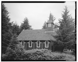
St. Michael the Archangel Church
St. Michael the Archangel Church is located in Cordova. This beautiful church is an example of Russian Orthodox architecture in Alaska. It shows the influence of Russian culture and religion in the state's history.

Slana Roadhouse
The Slana Roadhouse is at Mile 1 on Nebesna Road, near Slana. This historic roadhouse provided lodging and services for travelers on the early Alaskan trails, similar to the Gakona Roadhouse.

Tangle Lakes Archeological District
The Tangle Lakes Archeological District is near Paxson. This area is rich in archaeological finds, showing thousands of years of human activity. Its location is restricted to protect these important historical clues. It is a National Historic Landmark.
Valdez Trail-Copper Bluff Segment
The Valdez Trail-Copper Bluff Segment is at Milepost 106.5 on the Richardson Highway, near Copper City. The Valdez Trail was a very important route for miners and settlers traveling inland from the coast. This segment is a preserved part of that historic trail.
Former Listing
Sometimes, a place is removed from the National Register, often because it was destroyed or changed too much.
Sourdough Lodge
The Sourdough Lodge was located at Mile 147.5 on the Richardson Highway, near Gakona. This historic roadhouse was a popular stop for travelers. Sadly, it was destroyed by fire in 1992 and was removed from the list in 1993.
.jpg)
