
National Register of Historic Places listings in Whatcom County, Washington facts for kids

Have you ever wondered about the old buildings and special places around you? Many of these spots have amazing stories! In Whatcom County, Washington, there are many historic places that are so important, they've been added to a special list called the National Register of Historic Places. This list helps protect and celebrate buildings, areas, and even natural spots that are important to American history, architecture, or culture.
Whatcom County is home to 74 of these amazing places. Each one has a unique past, from old houses and grand theaters to natural landmarks and even a historic ferry! Let's explore some of these cool locations and learn about their history.
Contents
- Cool Historic Places in Whatcom County
- Buildings with a Past
- Aftermath Clubhouse: A Place for Women
- Dr. William H. and Frances C. Axtell House: A Doctor's Home
- B. P. O. E. Building: The Elk's Club
- George H. Bacon House: Family Ties
- Bellingham City Hall: Where Decisions Are Made
- Bellingham Herald Building: News from the Past
- Bellingham National Bank Building: A Strong Foundation
- Berthusen Barn and Privy: Farm Life History
- Alfred L. Black House: Also Known as Wahl House
- J. J. Donovan House: A University Connection
- Fairhaven Library: A Gift from Carnegie
- Flatiron Building: Bellingham's First "Skyscraper"
- Gamwell House: A Grand Home
- Great Northern Passenger Station: Travel by Train
- Hotel Laube: Under Renovation
- Immanuel School of Industries-Department of Public Welfare: A Place of Learning
- Larrabee House: A Vision Fulfilled
- Leopold Hotel: Now a Retirement Home
- Lynden Department Store: A Community Hub
- Montague and McHugh Building: Designed by a Famous Architect
- Morse Hardware Company Building: A Business Landmark
- Robert I. Morse House: A Family Home
- Mount Baker Theatre: A Grand Entertainment Spot
- Oakland Block: Providing Homes Today
- Old Main, Western Washington State College: A School's Heart
- Orchard Terrace Apartments: Modern Living in a Historic Building
- Pickett House: Bellingham's Oldest Building
- T. G. Richards and Company Store: The Oldest Brick Building
- Victor A. Roeder House: Educational Activities
- Lottie Roth Block: A Piece of Downtown
- Sanitary Meat Market: A Changing Storefront
- U.S. Post Office and Courthouse: Now City-Owned
- US Post Office-Lynden Main: Sending Mail for Decades
- James F. Wardner House: Wardner Castle
- Washington Grocery Company Warehouse: Storing Goods
- Whatcom Museum of History and Art: From City Hall to Museum
- Young Women's Christian Association: Supporting the Community
- Historic Districts: Whole Neighborhoods with Stories
- Broadway Park Historic District: A Beautiful Neighborhood
- Cissna Cottages Historic District: Charming Homes
- Downtown Bellingham Historic District: The Heart of the City
- Eldridge Avenue Historic District: A Grand Street
- Fairhaven Historic District: A Lively Old Town
- Sehome Hill Historic District: On the Hilltop
- South Hill Historic District: Another Historic Neighborhood
- York Historic District: A Diverse Area
- Natural and Industrial Wonders
- Austin Pass Warming Hut: A Mountain Shelter
- Beaver Pass Shelter: A Wilderness Stop
- Copper Mountain Fire Lookout: Watching for Wildfires
- Deer Lick Cabin: A Remote Cabin
- Desolation Peak Lookout: A Famous Viewpoint
- Devil's Corner Cliff Walk: A Scenic Path
- Diablo Hydroelectric Power Plant: Power from Water
- Fish and Game-Hozomeen Cabin: For Rangers and More
- Glacier Ranger Station: Forest Service History
- Gorge Hydroelectric Power Plants: More Water Power
- Hovander Homestead: A Historic Farm
- International Boundary US-Canada: A Border Landmark
- Koma Kulshan Ranger Station: Near Baker Lake
- Middle Fork Nooksack River Bridge: An Old Bridge
- MV Plover: A Historic Ferry
- Nooksack Falls Hydroelectric Power Plant: Power from Waterfalls
- Park Butte Lookout: High in the Mountains
- Peace Arch: A Symbol of Friendship
- Perry Creek Shelter: Another Wilderness Shelter
- Si'ke village with historic area called Tsi'lich: Ancient History
- Skagit River and Newhalem Creek Hydroelectric Projects: A Big Power System
- Sourdough Mountain Lookout: A Challenging Hike
- Wild Goose Pass Tree: A Natural Landmark
- Winchester Mountain Lookout: Overlooking Valleys
- Buildings with a Past
- Former Listings: Places That Were Once Historic
- Images for kids
Cool Historic Places in Whatcom County
Buildings with a Past
Whatcom County has many buildings that tell tales of earlier times. These aren't just old structures; they're pieces of history you can still see today!
Aftermath Clubhouse: A Place for Women
The Aftermath Clubhouse in Bellingham, Washington is a very special building. It was built in 1905 and is thought to be one of the first clubhouses made just for women in all of Washington State! It shows how women worked together to create their own spaces and communities long ago.
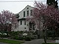
Dr. William H. and Frances C. Axtell House: A Doctor's Home
The Dr. William H. and Frances C. Axtell House, also in Bellingham, was built in 1909. Dr. Axtell was a well-known doctor in the area. This house gives us a peek into the lives of important people who helped shape the community in the early 1900s.
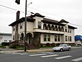
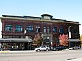
B. P. O. E. Building: The Elk's Club
The B. P. O. E. Building, also known as the Elk's Club, stands proudly in Bellingham. Built in 1912, this grand building was once a meeting place for a fraternal organization called the Benevolent and Protective Order of Elks. It's a great example of the fancy architecture from that time.
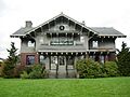
George H. Bacon House: Family Ties
The George H. Bacon House in Bellingham has an interesting family story. It was built in 1901 by Henry Bacon, who was George Bacon's first cousin. It's cool to think about how families built homes together and how those homes still stand today.
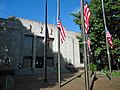
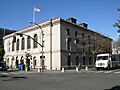
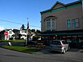
Bellingham City Hall: Where Decisions Are Made
Bellingham City Hall is a beautiful building where many important decisions for the city are made. Built in 1939, it's a great example of the Art Deco style, which was popular back then. It's a place where local history continues to be made every day.
Bellingham Herald Building: News from the Past
The Bellingham Herald Building was once home to the local newspaper, the Bellingham Herald. Built in 1926, this building played a big role in sharing news and stories with the people of Whatcom County for many years.
Bellingham National Bank Building: A Strong Foundation
The Bellingham National Bank Building was built in 1912. Banks were very important back then for helping towns grow and develop. This building shows the strong foundations of Bellingham's early economy.
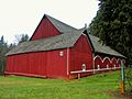
Berthusen Barn and Privy: Farm Life History
Out in Lynden, Washington, you can find the Berthusen Barn and Privy. This historic barn, built in 1910, and its outhouse, give us a glimpse into farm life in Whatcom County over a hundred years ago. It reminds us of the agricultural roots of the area.
Alfred L. Black House: Also Known as Wahl House
The Alfred L. Black House, built in 1909, is another historic home in Bellingham. It's also known as the Wahl House. Many old homes have different names over time, reflecting the families who lived there.
J. J. Donovan House: A University Connection
The J. J. Donovan House in Bellingham, built in 1909, has a unique history. For about 25 years, it was used as a women's dormitory by Western Washington University. Imagine students living in such a historic place!
Fairhaven Library: A Gift from Carnegie
The Fairhaven Library in Bellingham, built in 1904, is a special kind of library. It's one of the many "Carnegie Libraries" built across the country with money donated by Andrew Carnegie, a very rich businessman who believed in the power of reading and education.
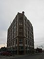
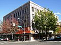
Flatiron Building: Bellingham's First "Skyscraper"
Bellingham's Flatiron Building, built in 1908, was considered the city's first "skyscraper" because of its unique triangular shape, like a clothes iron. It was originally built for the Bellingham Bay Furniture Co. It's a cool example of early tall buildings.
Gamwell House: A Grand Home
The Gamwell House in Bellingham, built in 1892, is a beautiful and grand home. It stands as a reminder of the elegant homes built during the late 19th century.
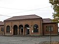
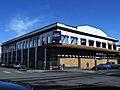
Great Northern Passenger Station: Travel by Train
The Great Northern Passenger Station in Bellingham, built in 1909, was once a busy train station. People would arrive and depart from here, connecting Bellingham to other parts of the country. Today, it's still used by the Burlington Northern-Santa Fe railway.
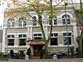
Hotel Laube: Under Renovation
The Hotel Laube in Bellingham, built in 1908, was once a bustling hotel. It's currently being remodeled, which means it will soon have a new life while keeping its historic charm.
Immanuel School of Industries-Department of Public Welfare: A Place of Learning
The Immanuel School of Industries-Department of Public Welfare in Bellingham, built in 1928, served as a place for learning and public welfare. It highlights efforts to help and educate people in the community during that time.
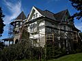
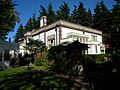
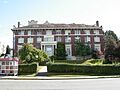
Larrabee House: A Vision Fulfilled
The Larrabee House in Bellingham, built in 1913, was commissioned by Charles Xavier Larrabee, a very important figure in Bellingham's history. Sadly, he passed away before it was finished. It's also known as Lairmont Manor and Mt. St. Mary's Novitiate, showing its different uses over the years.
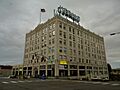
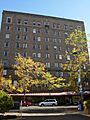
Leopold Hotel: Now a Retirement Home
The Leopold Hotel in Bellingham, built in 1929, was once a grand hotel. Today, it has a new purpose, housing a retirement home. It's a great example of how historic buildings can be adapted for modern uses.
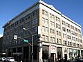
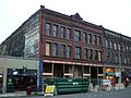
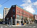
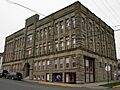
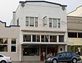
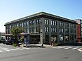
Lynden Department Store: A Community Hub
The Lynden Department Store in Lynden, Washington, built in 1909, was a central place for shopping and community life. Also known as the Waples Building / Delft Square, it was sadly damaged by fire in 2008 but remains a historic landmark.
Montague and McHugh Building: Designed by a Famous Architect
The Montague and McHugh Building in Bellingham, built in 1911, was designed by John Graham Sr., a famous architect. He designed many important buildings, and this one shows his skill and style.
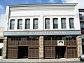
Morse Hardware Company Building: A Business Landmark
The Morse Hardware Company Building in Bellingham, built in 1904, was home to a hardware store that served the community for many years. It's a reminder of the local businesses that helped towns grow.
Robert I. Morse House: A Family Home
The Robert I. Morse House in Bellingham, built in 1904, was the home of Robert I. Morse. It's another example of the beautiful residential architecture from the early 20th century.
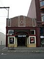
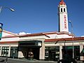
Mount Baker Theatre: A Grand Entertainment Spot
The Mount Baker Theatre in Bellingham, built in 1927, is a truly grand place! It was designed by Robert Reamer, who also designed the famous Old Faithful Inn in Yellowstone National Park. This theater was a popular spot for movies and shows, and it still is today!
Oakland Block: Providing Homes Today
The Oakland Block in Bellingham, built in 1908, has a new life today. It was recently remodeled to provide housing for people with low incomes. It's wonderful to see historic buildings being used to help the community.
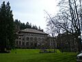
Old Main, Western Washington State College: A School's Heart
Old Main at Western Washington University in Bellingham, built in 1896, is one of the oldest and most important buildings on campus. It has been a center for learning for over a century, educating generations of students.
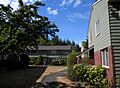
Orchard Terrace Apartments: Modern Living in a Historic Building
The Orchard Terrace Apartments in Bellingham, built in 1949, are a great example of how buildings from the mid-20th century are also becoming historic. They show the architectural styles of that time.
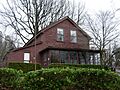
Pickett House: Bellingham's Oldest Building
The Pickett House in Bellingham, built in 1856, is super old! It was the home of George Pickett, a famous military officer. This house is the oldest building in Bellingham, making it a very important piece of local history.
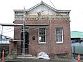
T. G. Richards and Company Store: The Oldest Brick Building
The T. G. Richards and Company Store in Bellingham, built in 1858, is another record-breaker! It later became the Washington Territorial Courthouse. This building is the oldest brick building in Washington State. Imagine all the history inside those walls!
Victor A. Roeder House: Educational Activities
The Victor A. Roeder House in Bellingham, built in 1909, now provides space for different educational activities. It's a great way for a historic home to continue serving the community.
Lottie Roth Block: A Piece of Downtown
The Lottie Roth Block in Bellingham, built in 1907, is an important part of the downtown area. Buildings like this show the growth and development of Bellingham's business district.
Sanitary Meat Market: A Changing Storefront
The Sanitary Meat Market in Bellingham, built in 1904, originally occupied several storefronts. Now, it's a smaller space, but it still stands as a reminder of the early businesses that served the community.
U.S. Post Office and Courthouse: Now City-Owned
The U.S. Post Office and Courthouse in Bellingham, built in 1913, was once a federal building. It's now owned by the city, showing how important public buildings are preserved and reused.
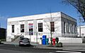
US Post Office-Lynden Main: Sending Mail for Decades
The US Post Office-Lynden Main in Lynden, built in 1937, has been where people in Lynden send and receive their mail for many years. It's a classic example of a post office from that era.
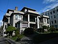
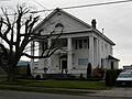
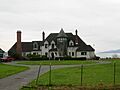
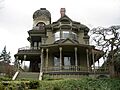
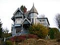
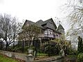
James F. Wardner House: Wardner Castle
The James F. Wardner House in Bellingham, built in 1890, is also known as Wardner Castle because of its grand appearance. Interestingly, James Wardner himself only lived in the home for one year!
Washington Grocery Company Warehouse: Storing Goods
The Washington Grocery Company Warehouse in Bellingham, built in 1903, was a place where groceries and other goods were stored before being sold. It shows the importance of trade and commerce in the early days of the city.
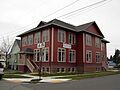
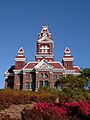
Whatcom Museum of History and Art: From City Hall to Museum
The Whatcom Museum of History and Art in Bellingham, built in 1892, has a cool story! It was originally the Bellingham City Hall. Now, it's a museum where you can learn all about the history and art of Whatcom County.
Young Women's Christian Association: Supporting the Community
The Young Women's Christian Association (YWCA) building in Bellingham, built in 1926, was a place that supported women and the community. Organizations like the YWCA played a big role in social welfare and education.
Historic Districts: Whole Neighborhoods with Stories
Sometimes, it's not just one building that's historic, but a whole group of them! These areas are called historic districts.
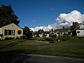
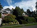
Broadway Park Historic District: A Beautiful Neighborhood
The Broadway Park Historic District in Bellingham is a neighborhood with many historic homes. Walking through it feels like stepping back in time, with beautiful old houses and tree-lined streets.
Cissna Cottages Historic District: Charming Homes
The Cissna Cottages Historic District in Bellingham features charming, smaller homes. These cottages show a different style of living from the grander houses and give us an idea of how different people lived in the past.
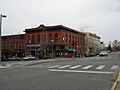
Downtown Bellingham Historic District: The Heart of the City
The Downtown Bellingham Historic District covers a large part of the city center. It includes many of the historic buildings we've already talked about, showing how the heart of Bellingham has grown and changed over time.
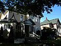
Eldridge Avenue Historic District: A Grand Street
The Eldridge Avenue Historic District in Bellingham is a long street lined with many historic homes. It's a beautiful area that shows the elegance of early Bellingham. It covers a large area with many buildings and structures.
Fairhaven Historic District: A Lively Old Town
The Fairhaven Historic District in Bellingham is a very popular area today, known for its shops and restaurants. But it's also packed with history! It was once a separate town with big plans to become a major city. The historic buildings here tell the story of that exciting time.
Sehome Hill Historic District: On the Hilltop
The Sehome Hill Historic District in Bellingham is located on a hill, offering great views. It includes many historic homes and shows how the city expanded onto the hillsides.
South Hill Historic District: Another Historic Neighborhood
The South Hill Historic District in Bellingham is another residential area with many historic homes. It's a great place to see different architectural styles from the past.
York Historic District: A Diverse Area
The York Historic District in Bellingham is a diverse neighborhood with a mix of historic homes and other buildings. It shows the different ways people lived and worked in Bellingham's past.
Natural and Industrial Wonders
Not all historic places are buildings! Some are natural features or important industrial sites.
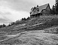
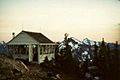
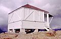
Austin Pass Warming Hut: A Mountain Shelter
The Austin Pass Warming Hut near Glacier, Washington, is a small shelter in the mountains. It was built in 1939 to provide warmth and safety for people exploring the snowy areas around Mount Baker.
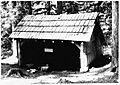
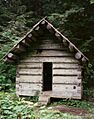
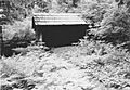
Beaver Pass Shelter: A Wilderness Stop
The Beaver Pass Shelter near Diablo, Washington, built in 1939, is another remote shelter. These shelters were important for explorers and workers in the vast wilderness of the North Cascades.
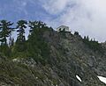
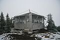
Copper Mountain Fire Lookout: Watching for Wildfires
The Copper Mountain Fire Lookout near Newhalem, Washington, built in 1932, was a vital spot for spotting wildfires. Lookouts like this helped protect forests and communities from dangerous fires.
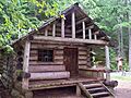
Deer Lick Cabin: A Remote Cabin
The Deer Lick Cabin near Hozomeen, WA, built in 1939, is a remote cabin in the wilderness. It was likely used by forest rangers or trappers.
Desolation Peak Lookout: A Famous Viewpoint
The Desolation Peak Lookout near Hozomeen, built in 1932, is famous for its incredible views. It was also a fire lookout. The writer Jack Kerouac spent time here, which made it even more well-known.
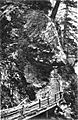
Devil's Corner Cliff Walk: A Scenic Path
The Devil's Corner Cliff Walk near Newhalem, built in 1922, is a scenic path along a cliff. It's part of the beautiful landscape of the Ross Lake National Recreation Area.
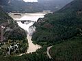
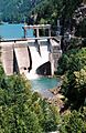
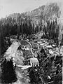
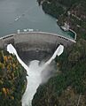
Diablo Hydroelectric Power Plant: Power from Water
The Diablo Hydroelectric Power Plant near Newhalem, built in 1930, is part of the larger Skagit River Hydroelectric Project. This plant uses the power of water to create electricity, which was a huge step forward for cities like Seattle.
Fish and Game-Hozomeen Cabin: For Rangers and More
The Fish and Game-Hozomeen Cabin near Hozomeen, built in 1939, was likely used by fish and game wardens or other officials working in the remote areas of the North Cascades.
Glacier Ranger Station: Forest Service History
The Glacier Ranger Station near Glacier, built in 1934, was an important base for the U.S. Forest Service. Rangers worked here to manage and protect the forests and natural resources.
Gorge Hydroelectric Power Plants: More Water Power
The Gorge Hydroelectric Power Plants near Newhalem, built in 1924, are another part of the Skagit River Hydroelectric Project. These plants are amazing examples of engineering that harnessed the power of the Skagit River.
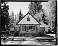
Hovander Homestead: A Historic Farm
The Hovander Homestead in Ferndale, Washington, is a historic farm that shows what life was like for early settlers. It's a great place to learn about farming history in Whatcom County.
International Boundary US-Canada: A Border Landmark
A section of the International Boundary US-Canada within Whatcom County is also listed as historic. This boundary, established in 1846, marks the line between the United States and Canada.
Koma Kulshan Ranger Station: Near Baker Lake
The Koma Kulshan Ranger Station near Concrete, Washington, built in 1934, is another ranger station in the Mount Baker National Forest. These stations were crucial for managing vast forest lands.
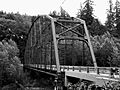
Middle Fork Nooksack River Bridge: An Old Bridge
The Middle Fork Nooksack River Bridge near Acme, Washington, built in 1912, is a historic bridge. Old bridges are important because they show us how engineers built structures long ago and how transportation developed.
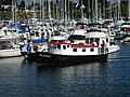
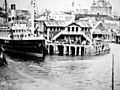
MV Plover: A Historic Ferry
The MV Plover in Blaine, Washington, launched in 1944, is a historic motor vessel. It's a ferry that has served the community for many years, connecting people across the water.
Nooksack Falls Hydroelectric Power Plant: Power from Waterfalls
The Nooksack Falls Hydroelectric Power Plant near Glacier, built in 1906, uses the power of the Nooksack Falls to generate electricity. It's a beautiful spot where nature and engineering meet.
Park Butte Lookout: High in the Mountains
The Park Butte Lookout near Sedro-Woolley, Washington, built in 1926, is another fire lookout high in the mountains. Imagine the views from up there!
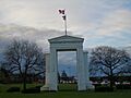
Peace Arch: A Symbol of Friendship
The Peace Arch in Blaine, built in 1921, is a famous monument on the Canada–United States border. It symbolizes peace and friendship between the United States and Canada. It's a very unique and meaningful historic place.
Perry Creek Shelter: Another Wilderness Shelter
The Perry Creek Shelter near Hozomeen, built in 1939, is another remote shelter in the North Cascades, providing refuge for those in the wilderness.
Si'ke village with historic area called Tsi'lich: Ancient History
The Si'ke village with historic area called Tsi'lich near Blaine represents ancient history. This site is important for understanding the lives and culture of the Native American people who lived in this area long before European settlers arrived.
Skagit River and Newhalem Creek Hydroelectric Projects: A Big Power System
The Skagit River and Newhalem Creek Hydroelectric Projects near Newhalem, built between 1918 and 1961, are a huge system of dams and power plants. They provide electricity to many homes and businesses, especially in Seattle. It's an amazing example of large-scale engineering.
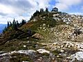
Sourdough Mountain Lookout: A Challenging Hike
The Sourdough Mountain Lookout near Diablo, built in 1933, is another fire lookout. Getting to it involves a challenging hike, but the views are incredible.
Wild Goose Pass Tree: A Natural Landmark
The Wild Goose Pass Tree near Glacier is a natural landmark. Sometimes, special trees or natural features are recognized for their historical or cultural importance.
Winchester Mountain Lookout: Overlooking Valleys
The Winchester Mountain Lookout near Sedro-Woolley, built in 1935, overlooks the Nooksack River and Silesia Creek. These lookouts were essential for protecting the vast forests of the region.
Former Listings: Places That Were Once Historic
Sometimes, a place that was once on the National Register of Historic Places might be removed from the list. This usually happens if the place is destroyed or changes so much that it no longer has its historic value.
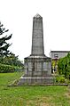
Citizen's Dock: Lost to a Storm
The Citizen's Dock in Bellingham was listed in 1981 but was removed in 2000. Sadly, it collapsed during a storm in 1986. This shows that even strong structures can be damaged by nature.
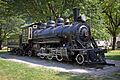
Old No. 6: A Train's Journey
Old No. 6 was a train located near Newhalem. It was listed in 1973 but removed shortly after because it was decided it didn't meet the requirements. However, it's now considered a contributing part of the Skagit River and Newhalem Creek Hydroelectric Projects historic district, meaning it's still recognized as important to that larger historic area.
Images for kids
-
Aftermath Clubhouse
-
Austin Pass Warming Hut
-
Dr. William H. and Frances C. Axtell House
-
B. P. O. E. Building
-
George H. Bacon House
-
Barlow Building
-
Beaver Pass Shelter
-
Bellingham City Hall
-
Bellingham Herald Building
-
Bellingham National Bank Building
-
Berthusen Barn
-
Alfred L. Black House
-
Boundary Marker No. 1
-
Broadway Park Historic District
-
Cissna Cottages Historic District
-
Copper Mountain Fire Lookout
-
Daylight Building
-
Deer Lick Cabin
-
Desolation Peak Lookout
-
Devil's Corner Cliff Walk
-
Diablo Hydroelectric Power Plant
-
J. J. Donovan House
-
Downtown Bellingham Historic District
-
Eldridge Avenue Historic District
-
Eldridge Homesite and Mansion
-
Fairhaven Historic District
-
Fairhaven Library
-
Fish and Game-Hozomeen Cabin
-
Flatiron Building
-
Gamwell House
-
Glacier Ranger Station
-
Gorge Hydroelectric Power Plants
-
Great Northern Passenger Station
-
Hotel Laube
-
Hovander Homestead
-
Immanuel School of Industries-Department of Public Welfare
-
Larrabee House
-
Leopold Hotel
-
Lynden Department Store
-
Middle Fork Nooksack River Bridge
-
Montague and McHugh Building
-
Morse Hardware Company Building
-
Robert I. Morse House
-
Mount Baker Theatre
-
MV Plover
-
Nooksack Falls Hydroelectric Power Plant
-
Oakland Block
-
Old Main, Western Washington State College
-
Orchard Terrace Apartments
-
Park Butte Lookout
-
Peace Arch
-
Perry Creek Shelter
-
Pickett House
-
T. G. Richards and Company Store
-
Victor A. Roeder House
-
Lottie Roth Block
-
Sanitary Meat Market
-
Sehome Hill Historic District
-
Si'ke village with historic area called Tsi'lich
-
Skagit River and Newhalem Creek Hydroelectric Projects
-
Sourdough Mountain Lookout
-
South Hill Historic District
-
U.S. Post Office and Courthouse
-
US Post Office-Lynden Main
-
James F. Wardner House
-
Washington Grocery Company Warehouse
-
Whatcom Museum of History and Art
-
Winchester Mountain Lookout
-
York Historic District
-
Young Women's Christian Association
-
Citizen's Dock (Former Listing)
-
Old No. 6 (Former Listing)


