Ndilǫ facts for kids
Quick facts for kids
Ndilǫ
|
|
|---|---|
|
Yellowknives Dene First Nation (Ndilǫ)
|
|
 |
|
| Country | Canada |
| Territory | Northwest Territories |
| Region | North Slave Region |
| Territorial electoral district | Tu Nedhé-Wiilideh |
| Census division | Region 6 |
| Elevation | 157 m (515 ft) |
| Population
(2016)GNWT estimate
|
|
| • Total | 321 |
| Time zone | UTC−07:00 (MST) |
| • Summer (DST) | UTC−06:00 (MDT) |
| Canadian Postal code |
X1A
|
| Area code(s) | 867 |
| Website | www.ykdene.com |
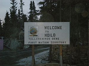
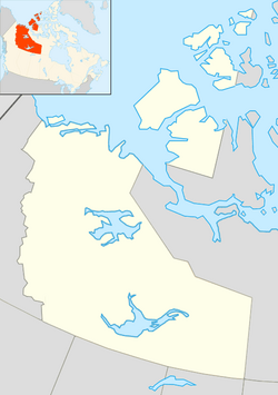
Ndilǫ (pronounced dee-loh) is a small community of First Nations people. It is located in the North Slave Region of the Northwest Territories, Canada. This Dene community sits on the edge of the city of Yellowknife, at the very tip of Latham Island. In 2016, about 321 people lived there.
Ndilǫ and another community called Dettah are home to the Yellowknives people. The people of Ndilǫ are part of the Yellowknives Dene First Nation. They are also part of the larger Akaitcho Territory Government. Traditionally, the people of Ndilǫ speak two Dene dialects: Wíílíídeh and Chipewyan (also known as Denesuline).
The land where Ndilǫ is located was set aside for status Indians by the Government of Canada in 1947. It was officially called 'Lot 500'. In 1959, the government built the first ten permanent houses for Dene families. These homes were very colourful, so people started calling the community 'Rainbow Valley'. By the 1970s, about 200 people lived in 20 houses. The community's name was officially changed to Ndilǫ in 1991. This name means "end of the island" in the local Dene language.
Climate and Weather in Ndilǫ
Ndilǫ has a subarctic climate. This means it has mild to warm summers and very long, cold winters.
Weather records for Ndilǫ are taken from the Yellowknife Airport. This airport is about 5 kilometers (3 miles) west of Ndilǫ.
| Climate data for Yellowknife (Yellowknife Airport) WMO ID: 71936; coordinates 62°27′46″N 114°26′25″W / 62.46278°N 114.44028°W; elevation: 205.7 m (675 ft); 1981–2010 normals, extremes 1942–present |
|||||||||||||
|---|---|---|---|---|---|---|---|---|---|---|---|---|---|
| Month | Jan | Feb | Mar | Apr | May | Jun | Jul | Aug | Sep | Oct | Nov | Dec | Year |
| Record high humidex | 2.9 | 6.1 | 8.9 | 20.2 | 25.6 | 34.0 | 35.4 | 34.3 | 27.2 | 18.1 | 6.3 | 1.6 | 35.4 |
| Record high °C (°F) | 3.4 (38.1) |
6.2 (43.2) |
9.3 (48.7) |
20.4 (68.7) |
26.3 (79.3) |
31.1 (88.0) |
32.5 (90.5) |
32.6 (90.7) |
26.1 (79.0) |
19.0 (66.2) |
7.8 (46.0) |
2.8 (37.0) |
32.6 (90.7) |
| Mean maximum °C (°F) | −7.3 (18.9) |
−4.9 (23.2) |
1.6 (34.9) |
11.4 (52.5) |
20.6 (69.1) |
26.3 (79.3) |
28.4 (83.1) |
26.5 (79.7) |
19.3 (66.7) |
10.2 (50.4) |
1.1 (34.0) |
−5.0 (23.0) |
28.8 (83.8) |
| Mean daily maximum °C (°F) | −21.6 (−6.9) |
−18.1 (−0.6) |
−10.8 (12.6) |
0.4 (32.7) |
9.7 (49.5) |
18.1 (64.6) |
21.3 (70.3) |
18.1 (64.6) |
10.4 (50.7) |
0.9 (33.6) |
−10.0 (14.0) |
−17.8 (0.0) |
0.0 (32.0) |
| Daily mean °C (°F) | −25.6 (−14.1) |
−22.9 (−9.2) |
−16.8 (1.8) |
−5.3 (22.5) |
4.6 (40.3) |
13.3 (55.9) |
17.0 (62.6) |
14.2 (57.6) |
7.2 (45.0) |
−1.7 (28.9) |
−13.7 (7.3) |
−21.8 (−7.2) |
−4.3 (24.3) |
| Mean daily minimum °C (°F) | −29.5 (−21.1) |
−27.5 (−17.5) |
−22.7 (−8.9) |
−11.0 (12.2) |
−0.5 (31.1) |
8.5 (47.3) |
12.6 (54.7) |
10.2 (50.4) |
4.0 (39.2) |
−4.2 (24.4) |
−17.5 (0.5) |
−25.7 (−14.3) |
−8.6 (16.5) |
| Mean minimum °C (°F) | −42.1 (−43.8) |
−39.8 (−39.6) |
−36.3 (−33.3) |
−25.7 (−14.3) |
−9.3 (15.3) |
1.9 (35.4) |
7.7 (45.9) |
3.6 (38.5) |
−2.6 (27.3) |
−15.8 (3.6) |
−31.1 (−24.0) |
−38.5 (−37.3) |
−43.1 (−45.6) |
| Record low °C (°F) | −51.2 (−60.2) |
−51.2 (−60.2) |
−43.3 (−45.9) |
−40.6 (−41.1) |
−22.8 (−9.0) |
−4.4 (24.1) |
0.6 (33.1) |
−0.6 (30.9) |
−9.7 (14.5) |
−28.9 (−20.0) |
−44.4 (−47.9) |
−48.3 (−54.9) |
−51.2 (−60.2) |
| Record low wind chill | −64.0 | −61.0 | −56.8 | −53.2 | −31.8 | −11.2 | 0.0 | −4.8 | −16.4 | −36.3 | −54.7 | −58.9 | −64.0 |
| Average precipitation mm (inches) | 14.3 (0.56) |
14.1 (0.56) |
13.9 (0.55) |
11.3 (0.44) |
18.4 (0.72) |
28.9 (1.14) |
40.8 (1.61) |
39.3 (1.55) |
36.3 (1.43) |
30.3 (1.19) |
24.8 (0.98) |
16.2 (0.64) |
288.6 (11.36) |
| Average rainfall mm (inches) | 0.1 (0.00) |
0.0 (0.0) |
0.2 (0.01) |
2.5 (0.10) |
13.8 (0.54) |
28.9 (1.14) |
40.8 (1.61) |
39.2 (1.54) |
32.7 (1.29) |
12.1 (0.48) |
0.3 (0.01) |
0.2 (0.01) |
170.7 (6.72) |
| Average snowfall cm (inches) | 19.7 (7.8) |
20.0 (7.9) |
18.5 (7.3) |
10.3 (4.1) |
4.7 (1.9) |
0.0 (0.0) |
0.0 (0.0) |
0.1 (0.0) |
3.5 (1.4) |
20.9 (8.2) |
36.5 (14.4) |
23.5 (9.3) |
157.6 (62.0) |
| Average precipitation days (≥ 0.2 mm) | 10.7 | 10.0 | 8.4 | 5.0 | 6.6 | 7.6 | 9.6 | 10.5 | 11.2 | 13.4 | 14.4 | 11.2 | 118.5 |
| Average rainy days (≥ 0.2 mm) | 0.2 | 0.1 | 0.3 | 1.2 | 5.3 | 7.5 | 9.6 | 10.4 | 10.6 | 5.5 | 0.6 | 0.2 | 51.3 |
| Average snowy days (≥ 0.2 cm) | 11.9 | 11.0 | 9.2 | 4.4 | 2.1 | 0.1 | 0.0 | 0.1 | 1.2 | 10.0 | 16.0 | 12.8 | 78.6 |
| Average relative humidity (%) | 64.6 | 61.6 | 54.7 | 52.5 | 45.9 | 45.2 | 47.9 | 55.7 | 64.7 | 75.2 | 77.8 | 69.2 | 59.6 |
| Mean monthly sunshine hours | 50.6 | 107.3 | 188.4 | 276.4 | 335.7 | 373.8 | 358.0 | 276.2 | 157.7 | 65.0 | 42.7 | 24.6 | 2,256.5 |
| Percent possible sunshine | 26.8 | 43.5 | 51.8 | 62.2 | 60.8 | 63.0 | 61.2 | 55.5 | 40.3 | 21.0 | 20.2 | 15.4 | 43.5 |
| Average ultraviolet index | 0 | 0 | 1 | 2 | 4 | 5 | 5 | 4 | 2 | 1 | 0 | 0 | 2 |
| Source 1: Environment and Climate Change Canada and Weather Atlas wind chill | |||||||||||||
| Source 2: Météo Climat (mean maximum) (mean minimum) | |||||||||||||
Notable People from Ndilǫ
 | Toni Morrison |
 | Barack Obama |
 | Martin Luther King Jr. |
 | Ralph Bunche |


