
Nederweert facts for kids
Quick facts for kids
Nederweert
Ni-jwieërt
|
|||
|---|---|---|---|

Saint Lambert church in Nederweert
|
|||
|
|||
.svg)
Location in Limburg
|
|||
| Country | Netherlands | ||
| Province | Limburg | ||
| Government | |||
| • Body | Municipal council | ||
| Area | |||
| • Total | 101.78 km2 (39.30 sq mi) | ||
| • Land | 100.23 km2 (38.70 sq mi) | ||
| • Water | 1.55 km2 (0.60 sq mi) | ||
| Elevation | 33 m (108 ft) | ||
| Population
(May 2014)
|
|||
| • Total | 16,747 | ||
| • Density | 167/km2 (430/sq mi) | ||
| Demonym(s) | Nederweerter | ||
| Time zone | UTC+1 (CET) | ||
| • Summer (DST) | UTC+2 (CEST) | ||
| Postcode |
6030–6035, 6090–6092
|
||
| Area code | 0495 | ||


Nederweert is a town and a municipality in the southeastern part of the Netherlands. It is located in the province of Limburg. The town has a population of about 16,747 people as of 2014.
Nederweert covers an area of about 101.78 km2 (39.30 sq mi). A small part of this area, about 1.55 km2 (0.60 sq mi), is water.
This town is special because it sits where three important canals meet. These are the Zuid-Willemsvaart, the Noordervaart, and the Wessem-Nederweert Canal. In the 1800s, these canals were used to transport peat. Peat is a type of soil that was dug up from the nearby Peel area. The canals also connect Nederweert to larger cities like Maastricht and 's-Hertogenbosch.
Contents
History of Nederweert
Nederweert has a long and interesting history. It was once known by a different name.
Early Names and Meanings
The original name for Nederweert was 'Merefelt'. This name means 'amongst the lakes'. Later, it was called Weert van den nedersten eynde. In old Dutch, a 'Weert' means a high place in the landscape. This name eventually changed to Nederweert, which is what we call it today.
Becoming Independent

Before the 14th century, Nederweert was part of the larger municipality of Weert. The first time Nederweert was mentioned as its own independent place was in the year 1419.
Changes in Rulers
For a long time, until 1701, Nederweert was ruled by the Graven van Horn, also known as the dukes of Horn. After that, in 1715, it became part of the southern states of the Netherlands.
In 1785, the French took control of Nederweert. During this time, it was part of a department called Nedermaas, which was connected to Belgium.
Important Buildings and Landmarks
Nederweert has some beautiful old buildings. These buildings show the town's rich history.
Sint-Lambertus Kerk

The most famous building in Nederweert is the Sint-Lambertus Kerk. This is a church built in the Brabantine Gothic style. It was finished in 1467, making it a very old and important monument.
Villages and Communities
The municipality of Nederweert includes several smaller villages and communities.
- Budschop
- Leveroy
- Nederweert
- Nederweert-Eind
- Ospel
- Ospeldijk
- Schoor
Famous People from Nederweert
Some notable people were born or lived in Nederweert.
- Margriet Tindemans (1951–2014): She was a musician who specialized in medieval music.
- Marie Kessels (born 1954): She is a Dutch poet and writer.
Images for kids
-
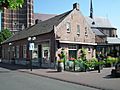
Restaurant Bi-J Siem, built in 1659
-
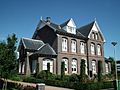
Front of the former rectory in Nederweert
-
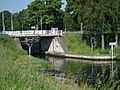
Sluis 15 in de Zuid-Willemsvaart
-
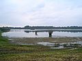
"De Banen", a lake in the nature area "Sarsven en De Banen", near Nederweert


See also
 In Spanish: Nederweert para niños
