
Maastricht facts for kids
Quick facts for kids
Maastricht
Mestreech (Limburgish)
|
|||
|---|---|---|---|
|
City and municipality
|
|||
|
River Meuse in winter
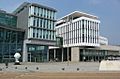
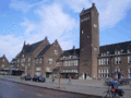
Maastricht City Hall at night
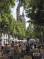
Sidewalk cafés at Onze Lieve Vrouweplein
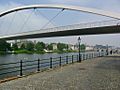
Saint Servatius Bridge
Our Lady, Star of the Sea chapel
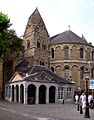
St. John's and St. Servatius' churches at Vrijthof square
View from Mount Saint Peter
|
|||
|
|||
| Anthem: Mestreechs Volksleed | |||
.svg)
Location in Limburg
|
|||

Maastricht
Location in Netherlands

Maastricht
Location in Europe
|
|||
| Country | Netherlands | ||
| Province | Limburg | ||
| Settled | c. 50 AD | ||
| City rights | gradually acquired | ||
| City Hall | Maastricht City Hall | ||
| Boroughs |
7 districts
Centrum (Binnenstad, Jekerkwartier, Kommelkwartier, Statenkwartier, Boschstraatkwartier, Sint Maartenspoort, Wyck-Céramique)
Noordoost (Beatrixhaven, Borgharen, Itteren, Meerssenhoven) Oost (Wyckerpoort, Wittevrouwenveld, Nazareth, Limmel, Amby, Scharn, Heugemerveld) Zuidoost (Randwyck, Heugem, Heer, De Heeg, Vroendaal) Zuidwest (Villapark, Jekerdal, Biesland, Campagne, Wolder, Sint Pieter) West (Brusselsepoort, Mariaberg, Belfort, Pottenberg, Malpertuis, Caberg, Malberg, Dousberg-Hazendans, Daalhof) Noordwest (Boschpoort, Bosscherveld, Frontenkwartier, Belvédère, Lanakerveld) |
||
| Government | |||
| • Body | Municipal council | ||
| Area | |||
| • Municipality | 60.03 km2 (23.18 sq mi) | ||
| • Land | 56.81 km2 (21.93 sq mi) | ||
| • Water | 3.22 km2 (1.24 sq mi) | ||
| Elevation | 49 m (161 ft) | ||
| Population
(Municipality, May 2014; Urban and Metro, May 2014)
|
|||
| • Municipality | 121,906 | ||
| • Density | 2,146/km2 (5,560/sq mi) | ||
| • Urban | 277,721 | ||
| • Metro | ≈ 3,500,000 | ||
| Urban population for Dutch-Belgian region; metropolitan population for Dutch-Belgian-German region. | |||
| Demonyms | (Dutch) Maastrichtenaar; (Limb.) Mestreechteneer or "Sjeng" (nickname) |
||
| Time zone | UTC+1 (CET) | ||
| • Summer (DST) | UTC+2 (CEST) | ||
| Postcode |
6200–6229
|
||
| Area code | 043 | ||


Maastricht is a historic city in the southeastern Netherlands. It is the capital and largest city of the Limburg province. The city sits on both sides of the Meuse river, where the Jeker river joins it. Mount Saint Peter is also part of the city's area. Maastricht is very close to the border with Belgium. It is part of a larger international area called the Meuse-Rhine Euroregion, which includes cities like Aachen in Germany and Liège in Belgium.
Maastricht started as a Roman settlement. Over time, it grew into an important center for trade and religion in the Middle Ages. Later, it became a military town and then an early industrial hub. Today, Maastricht is a lively cultural and regional center. It is famous for the Maastricht Treaty, which helped create the European Union and the euro currency. The city has many old buildings, with 1,677 national heritage sites. This is the second-highest number in the Netherlands, after Amsterdam. Tourists visit Maastricht for shopping and fun. It also has many international students. The last part of the Cretaceous period, when dinosaurs disappeared, is named the Maastrichtian after this city.
Contents
History of Maastricht
What's in a Name?
The name Maastricht comes from old words meaning "crossing the Meuse river." It was called Masa- (for the Meuse river) and *treiekt (meaning a place to cross a river). This is why it's called Maastricht, to avoid confusion with other places like Utrecht that have similar names.
People from Maastricht are called Maastrichtenaar. In the local dialect, they are called Mestreechteneer or even Sjeng. This nickname comes from the old French name Jean.
Early Beginnings

Very old human remains have been found near Maastricht. Neanderthals lived here long ago. Later, around 500 BC, Celts lived here. They chose this spot because the Meuse river was shallow and easy to cross.
The Romans arrived in Maastricht a long time ago. They built a bridge across the Meuse river in the 1st century AD. This bridge was a key part of a main road connecting important Roman cities. Roman Maastricht was not very big. Parts of the Roman road, the bridge, and old buildings have been found. You can see Roman coins, jewelry, and pottery at the city's public library, Centre Céramique.
A legend says that Saint Servatius, a bishop, died in Maastricht in 384 AD. He was buried along the Roman road. Later, around 570 AD, a church was built over his grave. This church was the beginning of the Basilica of Saint Servatius we see today. Maastricht was an early Christian center for a while.
The Middle Ages
In the early Middle Ages, Maastricht was a very important city. It was a center for river trade and making things. Coins made in Maastricht have been found all over Europe. In 881, Vikings attacked and robbed the town. For a short time in the 10th century, it was even the capital of a region called Lower Lorraine.
The city became a cultural hub in the 11th and 12th centuries. Many important church leaders from Maastricht held powerful positions. The two main churches were rebuilt and decorated beautifully. Art from Maastricht during this time, like stone sculptures and silver items, was very famous. A poet named Henric van Veldeke wrote a story about Saint Servatius, which is one of the oldest works in Dutch literature. The churches collected many holy items, and a special pilgrimage to Maastricht happened every seven years, attracting thousands of visitors.
Maastricht didn't get its "city rights" all at once like most towns. These rights developed slowly over time. By 1204, the city was officially ruled by two powers: the prince-bishop of Liège and the duke of Brabant. Soon after, the first city walls were built. In 1275, the old Roman bridge fell down, and a new one, the Sint Servaasbrug, was built. This bridge is still standing today.
During the Middle Ages, Maastricht was known for making wool and leather. However, its economy slowly declined. Wars in the 16th and 17th centuries made things worse. The city's economy only started to get better with the Industrial Revolution in the early 1800s.
From the 16th to 18th Centuries

Maastricht's location by the river meant it needed strong defenses. Many forts and walls were built around the city. In 1579, the Spanish army attacked and took over the city in the Siege of Maastricht (1579). The Spanish ruled Maastricht for over 50 years. In 1632, the Dutch took control of the city.
Another big attack happened in 1673 during the Franco-Dutch War. King Louis XIV of France attacked Maastricht. A famous French military engineer, Vauban, developed new ways to break through strong forts during this siege. These methods were used for centuries. During this attack, a brave captain-lieutenant named Charles de Batz de Castelmore, also known as d'Artagnan, was killed. This event is part of the famous novel The Vicomte de Bragelonne. French troops stayed in Maastricht from 1673 to 1678.
In 1748, the French took the city again. After each attack, the city's defenses were made even stronger. But in 1794, the French revolutionary army finally took Maastricht. The city became part of France for almost 20 years.
The 19th and Early 20th Centuries

After the time of Napoleon, Maastricht became part of the United Kingdom of the Netherlands in 1815. It became the capital of the new province of Limburg. When the southern parts of the kingdom broke away in 1830 to form Belgium, Maastricht stayed loyal to the Dutch king. Even though many people in Maastricht wanted to join Belgium, the city remained Dutch. This was confirmed by a treaty in 1839. During this time, Maastricht became an early industrial city.

Because Maastricht was far from the rest of the Netherlands and close to Belgium and Germany, it took time for it to feel fully Dutch. During World War I, the Netherlands stayed neutral. However, Maastricht took in many refugees, which put a strain on the city. In World War II, the city was quickly taken by the Germans in May 1940. On September 13 and 14, 1944, Maastricht was the first Dutch city to be freed by American forces. Most of the bridges over the Meuse were destroyed or damaged during the war. Sadly, many Jewish people from Maastricht died in Nazi camps.
After World War II

In the second half of the 20th century, old industries like pottery declined. The city's economy changed to focus more on services. Maastricht University was started in 1976. Many European organizations also set up offices in Maastricht. In 1981 and 1991, important European meetings were held here. The 1991 meeting led to the signing of the Maastricht Treaty a year later. This treaty was a big step in creating the European Union and the euro currency. Since 1988, The European Fine Art Fair (TEFAF), a world-famous art fair, has been held in Maastricht every year.
Since the 1990s, many parts of the city have been updated. This includes areas around the main train station and the Maasboulevard along the Meuse river. New shopping centers like Entre Deux and Mosae Forum were built. A new area with a museum, library, and theater was also created. Other big projects, like improving the area around the A2 motorway, are still being worked on.
Geography
City Areas


Maastricht is divided into seven main areas called wijken, which are then split into 44 smaller neighborhoods called buurten. Each area and neighborhood has a special code.
- Maastricht Centrum (City Center): Includes Binnenstad, Jekerkwartier, Kommelkwartier, Statenkwartier, Boschstraatkwartier, Sint Maartenspoort, Wyck-Céramique.
- South-West: Includes Villapark, Jekerdal, Biesland, Campagne, Wolder, Sint Pieter.
- West: Includes Brusselsepoort, Mariaberg, Belfort, Pottenberg, Malpertuis, Caberg, Malberg, Dousberg-Hazendans, Daalhof.
- North-West: Includes Boschpoort, Bosscherveld, Frontenkwartier, Belvédère, Lanakerveld.
- North-East: Includes Beatrixhaven, Borgharen, Itteren, Meerssenhoven.
- East: Includes Wyckerpoort, Wittevrouwenveld, Nazareth, Limmel, Amby, Scharn, Heugemerveld.
- South-East: Includes Randwyck, Heugem, Heer, De Heeg, Vroendaal.
Some of these neighborhoods, like Itteren and Sint Pieter, used to be separate villages. They became part of Maastricht during the 20th century.
Nearby Towns
Maastricht is surrounded by other towns and villages. Here are some of the places that border Maastricht:
- Bunde
- Meerssen
- Berg en Terblijt
- Bemelen
- Cadier en Keer
- Gronsveld
- Oost
- Lanaye (Belgium)
- Petit-Lanaye (Belgium)
- Kanne (Belgium)
- Vroenhoven (Belgium)
- Kesselt (Belgium)
- Veldwezelt (Belgium)
- Lanaken (Belgium)
- Neerharen (Belgium)
International Border
Maastricht's city limits touch the international border with Belgium. Most of this border is with Belgium's Flemish region. A smaller part to the south borders the Wallonia region. Both the Netherlands and Belgium are part of the Schengen Area. This means people can cross the border without passport checks.
Climate
Maastricht has a climate similar to most of the Netherlands. However, because it's more inland and surrounded by hills, summers can be a bit warmer. Winters can be a little colder. The highest temperature ever recorded in Maastricht was 39.6°C on July 25, 2019.
| Climate data for Maastricht (1991−2020 normals, extremes 1906−present) | |||||||||||||
|---|---|---|---|---|---|---|---|---|---|---|---|---|---|
| Month | Jan | Feb | Mar | Apr | May | Jun | Jul | Aug | Sep | Oct | Nov | Dec | Year |
| Record high °C (°F) | 16.5 (61.7) |
19.8 (67.6) |
24.2 (75.6) |
29.7 (85.5) |
33.1 (91.6) |
37.2 (99.0) |
39.6 (103.3) |
36.8 (98.2) |
34.3 (93.7) |
28.7 (83.7) |
21.4 (70.5) |
17.0 (62.6) |
39.6 (103.3) |
| Mean maximum °C (°F) | 12.5 (54.5) |
13.6 (56.5) |
18.3 (64.9) |
23.2 (73.8) |
27.3 (81.1) |
30.9 (87.6) |
32.5 (90.5) |
31.8 (89.2) |
26.8 (80.2) |
22.1 (71.8) |
16.3 (61.3) |
12.8 (55.0) |
34.3 (93.7) |
| Mean daily maximum °C (°F) | 5.7 (42.3) |
6.7 (44.1) |
10.7 (51.3) |
15.0 (59.0) |
18.8 (65.8) |
21.7 (71.1) |
23.8 (74.8) |
23.5 (74.3) |
19.7 (67.5) |
14.8 (58.6) |
9.7 (49.5) |
6.3 (43.3) |
14.7 (58.5) |
| Daily mean °C (°F) | 3.2 (37.8) |
3.7 (38.7) |
6.6 (43.9) |
10.1 (50.2) |
13.8 (56.8) |
16.8 (62.2) |
18.8 (65.8) |
18.4 (65.1) |
15.0 (59.0) |
11.0 (51.8) |
6.8 (44.2) |
4.0 (39.2) |
10.7 (51.3) |
| Mean daily minimum °C (°F) | 0.5 (32.9) |
0.7 (33.3) |
2.7 (36.9) |
5.0 (41.0) |
8.7 (47.7) |
11.7 (53.1) |
13.8 (56.8) |
13.4 (56.1) |
10.6 (51.1) |
7.3 (45.1) |
3.8 (38.8) |
1.4 (34.5) |
6.6 (43.9) |
| Mean minimum °C (°F) | −7.3 (18.9) |
−6.0 (21.2) |
−3.5 (25.7) |
−1.0 (30.2) |
2.5 (36.5) |
6.4 (43.5) |
9.0 (48.2) |
8.8 (47.8) |
5.6 (42.1) |
0.8 (33.4) |
−2.6 (27.3) |
−5.5 (22.1) |
−9.5 (14.9) |
| Record low °C (°F) | −19.3 (−2.7) |
−21.4 (−6.5) |
−12.9 (8.8) |
−5.6 (21.9) |
−1.6 (29.1) |
0.7 (33.3) |
4.3 (39.7) |
4.9 (40.8) |
−0.9 (30.4) |
−6.5 (20.3) |
−12.0 (10.4) |
−18.3 (−0.9) |
−21.4 (−6.5) |
| Average precipitation mm (inches) | 63.8 (2.51) |
57.6 (2.27) |
54.6 (2.15) |
41.0 (1.61) |
57.7 (2.27) |
68.9 (2.71) |
72.8 (2.87) |
82.8 (3.26) |
57.5 (2.26) |
63.6 (2.50) |
62.2 (2.45) |
74.3 (2.93) |
756.8 (29.80) |
| Average precipitation days (≥ 1 mm) | 12.0 | 10.8 | 10.4 | 8.4 | 9.4 | 9.7 | 10.2 | 10.2 | 8.8 | 10.7 | 11.7 | 13.2 | 125.7 |
| Average snowy days | 6.1 | 6.7 | 3.3 | 0.3 | 0.1 | 0.0 | 0.0 | 0.0 | 0.0 | 0.1 | 1.1 | 4.7 | 22.2 |
| Average relative humidity (%) | 86.4 | 83.2 | 77.7 | 71.7 | 72.1 | 72.8 | 73.1 | 74.8 | 79.4 | 83.9 | 87.9 | 88.3 | 79.3 |
| Mean monthly sunshine hours | 66.9 | 86.0 | 138.5 | 180.8 | 208.7 | 205.5 | 209.0 | 197.5 | 157.0 | 118.2 | 74.1 | 53.5 | 1,695.7 |
| Percent possible sunshine | 25.4 | 30.3 | 37.5 | 43.7 | 43.4 | 41.7 | 42.1 | 43.8 | 41.3 | 35.5 | 27.4 | 21.5 | 36.1 |
| Source: Royal Netherlands Meteorological Institute (snowy days 2003–2020) Infoclimat | |||||||||||||
People of Maastricht
| Historical population | ||
|---|---|---|
| Year | Pop. | ±% p.a. |
| 1400 | 7,000 | — |
| 1500 | 10,000 | +0.36% |
| 1560 | 13,500 | +0.50% |
| 1600 | 12,600 | −0.17% |
| 1650 | 18,000 | +0.72% |
| 1740 | 12,500 | −0.40% |
| 1796 | 17,963 | +0.65% |
| 1818 | 20,000 | +0.49% |
| 1950 | 77,710 | +1.03% |
| 1960 | 90,202 | +1.50% |
| 1970 | 93,927 | +0.41% |
| 1980 | 109,285 | +1.53% |
| 1990 | 117,008 | +0.69% |
| 2000 | 122,070 | +0.42% |
| 2010 | 118,533 | −0.29% |
| 2020 | 121,575 | +0.25% |
| Source: (1400–1795) Statistics Netherlands |
||
People from Different Countries
Maastricht is home to people from many different countries. This is partly because of its location near other countries and its international student population.
| Nationality | 2021 | 2014 | 2010 | 2000 |
|---|---|---|---|---|
| 100,297 | 107,418 | 109,722 | 116,171 | |
| 3,908 | 3,869 | 1,956 | 783 | |
| 1,572 | 653 | 387 | 280 | |
| 1,475 | 1,055 | 946 | 909 | |
| 913 | 431 | 232 | 241 | |
| 842 | 815 | 386 | 280 | |
| 739 | 595 | 248 | 87 | |
| 686 | 351 | 214 | 120 | |
| 665 | 623 | 277 | 162 | |
| 436 | 404 | 368 | 404 |
Birthplaces of Residents
Many people living in Maastricht were born in other countries. Here's a look at the top 10 countries of birth for Maastricht residents.
| Country of birth | 2020 | 2013 | 2010 | 2000 |
|---|---|---|---|---|
| 93,162 | 100,269 | 102,433 | 109,632 | |
| 3,949 | 4,100 | 2,467 | 1,444 | |
| 2,355 | 1,920 | 1,839 | 1,900 | |
| 1,380 | 753 | 383 | 217 | |
| 1,020 | 1,199 | 1,267 | 1,556 | |
| 1,019 | 651 | 373 | 215 | |
| 973 | 919 | 836 | 784 | |
| 926 | 677 | 404 | 310 | |
| 829 | 838 | 867 | 859 | |
| 563 | 437 | 316 | 152 |
Languages Spoken
Maastricht is a city where many languages are spoken. This is because it's located where different language areas meet. Also, many international students live here.
- Dutch is the main language of the Netherlands. It's used in schools and for official business. People in Maastricht often speak Dutch with a special Limburgish accent. This accent is different from the Limburgish language itself.
- Limburgish is a group of dialects spoken in the Limburg provinces of both the Netherlands and Belgium. The Maastrichtian dialect (Mestreechs) is one type of Limburgish. It has long vowel sounds and some French words. This dialect is becoming less common as more people speak standard Dutch.
- French used to be very important in Maastricht for education and culture. In the 18th and 19th centuries, it was the language of government and was preferred by the upper classes. Many street names in Maastricht are French. French words have also influenced the local dialect.
- German is also taught in many secondary schools. Because Maastricht is close to Germany and has many German students, German is widely spoken.
- English has become very important in education. At Maastricht University and Hogeschool Zuyd, many courses are taught in English. Many foreign students and people from other countries use English to communicate. English is also a required subject in Dutch secondary schools.
Religion
Religions in Maastricht (2013) Roman Catholic (60.1%) Protestant Church in the Netherlands (2.8%) Other Christian denominations (2.2%) Islam (3.3%) Hinduism (0.1%) Buddhism (0.4%) Judaism (0.2%) No affiliation (30.9%)
Between 2010 and 2014, about 70% of people in Maastricht said they were religious. Most of them, about 60%, were Roman Catholic. About 14% of the population attended a religious ceremony at least once a month.
Economy


Companies in Maastricht
Many different companies have their base in Maastricht. These include:
- Sappi – a company that makes pulp and paper.
- Royal Mosa – known for ceramic tiles.
- O-I Manufacturing – makes glass products.
- BASF – produces pigments.
- Mondi – a packaging company.
- Rubber Resources/Elgi Rubber – recycles rubber.
- Radium Foams – makes special foam products.
- Hewlett-Packard – a technology company.
- Vodafone – a mobile phone company.
- Q-Park – manages parking garages.
- DHL – provides international express mail services.
- Teleperformance – offers contact center services.
- Mercedes-Benz – has a customer contact center for Europe here.
- VGZ – a health insurance company.
- Pie Medical Imaging – creates software for heart and blood vessel analysis.
- Esaote – makes medical and veterinary diagnostic equipment.
- BioPartner Centre Maastricht – supports new life sciences companies.
- Medtronic – a medical devices company with a research and development center.
Public Organizations


Since the 1980s, many European and international organizations have chosen Maastricht as their home. They offer many jobs, especially for people from other countries.
- The government office for the Dutch province of Limburg.
- Meuse-Rhine Euroregion – a group that works together across borders.
- Limburg Development Company LIOF – helps businesses grow in Limburg.
- RHCL and SHCL – archives for the Limburg province.
- Eurocontrol – helps manage air traffic safety in Europe.
- European Journalism Centre – supports journalism.
- European Institute of Public Administration (EIPA) – trains public officials.
- European Centre for Development Policy Management (ECDPM) – works on development policy.
- European centre for work and society (ECWS).
- Maastricht Centre for Transatlantic Studies (MCTS).
- Expert Centre for Sustainable Business and Development Cooperation (ECSAD).
- Council of European Municipalities and Regions (REGR).
- European Centre for Digital Communication (EC/DC).
- UNU-MERIT – a research and training center.
- Maastricht Research School of Economics of TEchnology and ORganization (METEOR).
- Research Institute for Knowledge Systems (RIKS).
- Cicero Foundation (CF).
Culture and Tourism


.jpg)


_(5a).JPG)


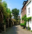
Maastricht is famous for its lively squares, narrow streets, and old buildings. The city has 1,677 national heritage buildings, which is a lot for a Dutch city. The entire city center is a protected area and mostly free of cars. The tourist information office is in the basement of Dinghuis, an old courthouse.
Main Sights of Maastricht
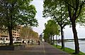
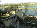
- Meuse river: You can find parks and walking paths along the river. There are also interesting bridges:
- Sint Servaasbrug: This bridge is partly from the 13th century and is the oldest bridge in the Netherlands.
- Hoge Brug ("High Bridge"): A modern bridge for people walking, designed by René Greisch.
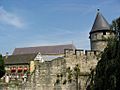
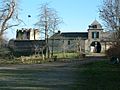
- City Defenses: These include old walls and forts:
- Old city walls: Parts of the first and second medieval city walls and several towers from the 13th and 14th centuries.
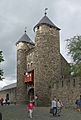
- Helpoort ("Hell's Gate"): A large gate with two towers, built around 1230. It's the oldest city gate in the Netherlands.
- Hoge Fronten: Parts of 17th and 18th-century forts, with well-preserved walls and moats.
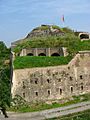
- Fort Sint-Pieter: An early 18th-century fort on Mount Saint Peter. You can take guided tours and see great views of the city.
- Casemates: An underground network of tunnels, built for guns and cannons. These tunnels are about 14 kilometers long. Guided tours are available.
- Binnenstad (Inner City): This area is for pedestrians and has popular shopping streets. Many sights, cafes, and restaurants are around three main squares:
- Vrijthof: The largest and most famous square in Maastricht. It has many pubs and restaurants.
- Basilica of Saint Servatius: A beautiful Romanesque church with old sculptures. The tomb of Saint Servatius is a popular pilgrimage site. The church also has an important treasury.
- Sint-Janskerk: A Gothic church next to the Basilica of Saint Servatius. It has a unique red limestone tower.
- Spaans Gouvernement ("Spanish Government Building"): A 16th-century building now home to the Fotomuseum aan het Vrijthof.
- Onze Lieve Vrouweplein: A tree-lined square with outdoor cafes.
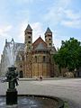
- Basilica of Our Lady: A church partly from the 11th century, known for its shrine of Our Lady, Star of the Sea.
- Derlon Museumkelder: An exhibit of ancient Roman ruins in the basement of Hotel Derlon.
- Markt (Market Square): The city's historic market square.
- The Town Hall: Built in the 17th century, it's a great example of Dutch Baroque style.
- Entre Deux: A modern shopping center that includes a bookstore inside a former 13th-century Dominican church. This bookstore has been called one of the most beautiful in the world.
- Vrijthof: The largest and most famous square in Maastricht. It has many pubs and restaurants.
- Jekerkwartier: This area is named after the small Jeker river. It has many university buildings and art schools.
- Maastricht Natural History Museum: A small museum about the natural history of Limburg.
- Wyck: The old part of the city on the east side of the Meuse river.
- Saint Martin's Church: A Gothic Revival church designed in 1856.
- Rechtstraat and Hoogbrugstraat: The oldest streets in Wyck, with historic buildings, shops, and restaurants.
- Céramique: A modern area built where old pottery factories used to be. It has a park along the Meuse river and interesting buildings.
- Bonnefanten Museum: Designed by Aldo Rossi, it has a unique rocket-shaped tower.
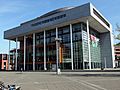
- Centre Céramique: A public library and exhibition space.
- Sint-Pietersberg ("Mount Saint Peter"): A small hill and nature reserve south of the city. It's a great place for recreation and views.
- Caves of Maastricht: An underground network of man-made tunnels in limestone quarries. Guided tours are available.
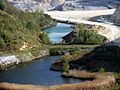
- ENCI Quarry: A former quarry and nature reserve with lakes.
- Slavante: A popular spot with great views over the Meuse valley.
Museums in Maastricht
- Bonnefanten Museum: This museum shows old master paintings and modern art. It has medieval sculptures and works by famous artists.
- The Treasury of the Basilica of Saint Servatius: This museum has religious items from the 4th to 20th centuries. It includes items related to Saint Servatius.
- The Treasury of the Basilica of Our Lady: Contains religious art, textiles, and other items from the Middle Ages.
- Derlon Museumkelder: An archaeological site in a hotel basement, showing Roman and older remains.
- The Maastricht Natural History Museum: Shows collections about the geology, fossils, plants, and animals of Limburg. It has parts of Mosasaur skeletons found in a quarry.
- Fotomuseum aan het Vrijthof: A photography museum in a 16th-century building. It has temporary exhibits by photographers.
Events and Festivals
Maastricht hosts many exciting events throughout the year:
- Dies natalis: The birthday of Maastricht University (January 9).
- Carnival (Vastelaovend): A three-day festival with music and parades (February/March).
- The European Fine Art Fair (TEFAF): A world-leading art and antiques fair (March).
- Tattoo Expo Maastricht: An international tattoo exhibition (March).
- Amstel Gold Race: An international cycling race that starts in Maastricht (usually April).
- Pilgrimage of the Relics (Heiligdomsvaart): A Christian pilgrimage with relics on display (May/June; every 7 years; next in 2032).
- Giants' Parade (Reuzenstoet): A parade of large processional giants (June; every 5 years; next in 2024).
- Vrijthof concerts by André Rieu: Famous outdoor concerts (July/August).
- Preuvenemint: A large food festival on Vrijthof square (August).
- Inkom: The start of the academic year for new university students (August).
- Musica Sacra: A festival of religious classical music (September).
- Nederlandse Dansdagen (Netherlands Dance Days): A modern dance festival (October).
- Jazz Maastricht: A jazz festival (autumn).
- 11de van de 11de: The official start of the carnival season (November 11).
- Jumping Indoor Maastricht: An international horse showjumping event (November).
- Magic Maastricht (Magisch Maastricht): A winter funfair and Christmas market (December/January).
The Maastricht Exposition and Congress Centre (MECC) also hosts many events all year.
Nature


Parks
Maastricht has several city parks and green areas:
- Stadspark: The main public park, with parts of medieval city walls, a branch of the Jeker river, and a mini-zoo. It also has a statue of d'Artagnan.
- Jekerpark: A new park along the Jeker river.
- Frontenpark: A new park west of the city center, including parts of Maastricht's old fortifications.
- Charles Eykpark: A modern park on the east bank of the Meuse river.
- Griendpark: A modern park on the east bank of the river with areas for inline-skating and skateboarding.
- Geusseltpark and J.J. van de Vennepark: Both have sports facilities.
Natural Areas
- The Meuse river: Its green banks in the outer areas are beautiful. New natural areas are being created here.
- Pietersplas: A lake created from gravel pits near the Meuse river. It has a beach and a marina.
- The Jeker Valley: This area along the Jeker river has green meadows, fields, vineyards, and old water mills.
- Sint-Pietersberg ("Mount Saint Peter"): This hill is a nature reserve with many walking paths.
- Dousberg and Zouwdal: A small hill and valley on the western edge of the city, partly in Belgium. A large part of the hill is now a golf course.
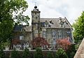
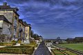
- Landgoederenzone: An area in northeast Maastricht with about 15 country estates and castles.
- Bike paths: You can find bike paths through farming areas in several outer neighborhoods.
Sports

- Football: Maastricht has a football team called MVV Maastricht. They play in the Dutch first division, which is the second-highest league. Their home stadium is the Geusselt stadium.
- American Football: Maastricht is also home to the Maastricht Wildcats, an American Football team.
- Cycling: Since 1998, Maastricht has been the starting point of the annual Amstel Gold Race, a famous Dutch cycling race. Tom Dumoulin, a well-known cyclist, was born in Maastricht.
- Lacrosse: Maastricht was the first city in the Netherlands to have a Lacrosse team, called "Maaslax."
Politics
City Council
| Parties | 2014 |
2018 |
2022 |
|---|---|---|---|
| Senioren Partij Maastricht (SPM) | 6 | 5 | 5 |
| CDA | 5 | 5 | 4 |
| D66 | 5 | 5 | 4 |
| GroenLinks | 4 | 5 | 4 |
| PvdA | 5 | 3 | 4 |
| VVD | 3 | 3 | 3 |
| Partij Veilig Maastricht | 3 | 3 | 3 |
| SP | 5 | 3 | 2 |
| Party for the Animals (PvdD) | – | – | 2 |
| Volt | – | – | 2 |
| Party for Freedom (PVV) | – | 2 | 1 |
| Liberale Partij Maastricht (LPM) | 1 | 1 | 1 |
| 50PLUS (50+) | – | 1 | 1 |
| Sociaal Actieve Burgerpartij (SAB) | – | 1 | 1 |
| M:OED | – | 2 | 1 |
| Forum for Democracy (FvD) | – | – | 1 |
| Stadsbelangen Mestreech (SBM) | 1 | – | – |
| Christelijke Volkspartij (Maastricht) | 1 | – | – |
| Total | 39 | 39 | 39 |
Maastricht's local government has a city council, a mayor, and several aldermen. The city council has 39 members. They are elected every four years and choose the aldermen.
Mayors of Maastricht
The mayor and aldermen manage the city's daily operations. Wim Hillenaar became the mayor in July 2023.
Transport
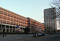
.jpg)


Getting Around by Bike
Maastricht is a great city for biking. You can cross the river using any of the city's bridges.
Traveling by Car
Maastricht is connected by the A2 and A79 highways. You can reach Brussels and Cologne in about an hour. Amsterdam is about two and a half hours away.
The A2 motorway goes through Maastricht in a special two-level tunnel. Before 2016, the highway caused a lot of traffic and air pollution in the city. The tunnel was built to solve these problems and opened in stages by December 2016.
Parking in the city center can be difficult, especially on weekends and holidays. Parking fees are high to encourage people to use public transport or park outside the center.
Traveling by Train
Maastricht has three train operators. All of them stop at the main Maastricht railway station. Two also stop at the smaller Maastricht Randwyck railway station, near the university. Only Arriva stops at Maastricht Noord railway station, which opened in 2013.
- Dutch Railways runs intercity trains north to cities like Amsterdam and Utrecht.
- Arriva operates trains to Heerlen, Valkenburg, and Kerkrade.
- The National Railway Company of Belgium runs trains south to Liège in Belgium.
Traveling by Bus
Regular bus lines connect the city center, outer areas, and train stations. The regional Arriva bus network covers most of South Limburg and goes to Aachen in Germany. Regional buses by De Lijn connect Maastricht with Hasselt, Tongeren, and Maasmechelen in Belgium. One bus connects Maastricht with Liège, operated by TEC. Other bus companies like Flixbus and Eurolines offer long-distance bus services to many European cities.
Traveling by Air
Maastricht is served by the nearby Maastricht Aachen Airport (MST/EHBK), located about 10 kilometers north of the city. Airlines like Corendon Dutch Airlines and Ryanair offer flights to places around the Mediterranean, the Canary Islands, North Africa, and London Stansted Airport. There are also charter flights to Lourdes.
Traveling by Boat
Maastricht has a river port called Beatrixhaven. It is connected by water to Belgium and the rest of the Netherlands through the Meuse river and several canals. While there are no regular boat connections to other cities, you can take organized boat trips for tourists to Belgian cities like Liège.
Distances to Other Cities
Here are the straight-line distances to some other cities:
 Liège: 25.5 km south
 Aachen: 31.0 km east
 Eindhoven: 66.8 km north-west
- Düsseldorf: 86.2 km north-east
- Cologne: 89.6 km east
- Brussels: 95.1 km west
- Antwerp: 97.8 km north-west
- Bonn: 99.9 km south-east
- Charleroi: 102.1 km south-west
- Mons: 130.8 km south-west
 Luxembourg City: 141.4 km south
- Ghent: 141.5 km west
- Utrecht: 142.4 km north-west
- Rotterdam: 144.5 km north-west
- Amsterdam: 175.1 km north-west
 Lille: 186.3 km west
- Frankfurt am Main: 228.8 km south-east
- Groningen: 269.6 km north
- Strasbourg: 288.7 km south-east
- Paris: 325.6 km south-west
- Hannover: 325.7 km north-east
- Stuttgart: 341.3 km south-east
 Basel: 390.2 km south-east
- Zürich: 438.7 km south-east
 London: 411.5 km north-west
Education


High Schools
- Bernard Lievegoedschool (a special type of education)
- Bonnefantencollege
- Porta Mosana College
- Sint-Maartenscollege
- United World College Maastricht
Universities and Colleges
- Maastricht University (UM): This includes University College Maastricht and Maastricht School of Management.
- Zuyd University of Applied Sciences (Hogeschool Zuyd): This university also has departments in Sittard and Heerlen. It includes:
- Academy for Dramatic Arts Maastricht
- School of Fine Arts Maastricht
- Maastricht Academy of Music
- Academy of architecture
- Faculty of International Business and Communication
- Maastricht Hotel Management School
Other Educational Places
- Jan Van Eyck Academie - a post-academic art institute.
- Berlitz Language School Maastricht.
- Talenacademie Nederland.
International Connections
Twin Towns
Maastricht has special connections with other cities around the world. These are called twin towns:
Famous People from Maastricht

.jpg)


Born in Maastricht
- Peter Debye (1884–1966) – a chemist who won a Nobel Prize.
- Tom Dumoulin (born 1990) – a cyclist who won the 2017 Giro d'Italia.
- Jan Pieter Minckeleers (1748–1824) – a scientist who invented coal gas lighting.
- Henrietta d'Oultremont (1792–1864) – the second wife of William I of the Netherlands.
- André Rieu (born 1949) – a famous violinist, conductor, and composer.
- Victor de Stuers (1843–1916) – a politician who worked to preserve old buildings.
- Frans Timmermans (born 1961) – a well-known politician.
- Boudewijn Zenden (born 1976) – a football player.
People Who Lived in Maastricht

- Saint Servatius (4th century–384?) – a bishop and saint.
- Henric van Veldeke (12th century) – a poet.
Local Anthem
In 2002, the city government officially adopted a local anthem. It's called Mestreechs Volksleed in the local dialect. The words were written by Alfons Olterdissen.
| Maastrichtian municipal anthem (Mestreechs Volksleed) (adopted 2002, written 1910) |
|---|
|
Images for kids
-
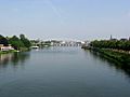
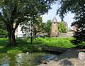
The Meuse
-
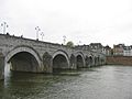
Saint Servatius Bridge
-
Dinghuis
-
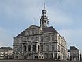
Townhall
-
Mosae Forum
-
Saint Servatius Basilica
-
Onze-Lieve-Vrouweplein
-
Basilica of Our Lady
-
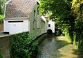
Lang Grachtje
-
Helpoort ("Hell's Gate")
-
Pater Vink Tower
-
Bastion Haet ende Nijt
-
Stadspark
-
Jeker river
-
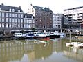
Bassin harbour
-
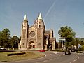
Saint Lambert Church
-
Train station, Wyck
-
Stationsplein, Wyck
-
Hoeg Brögk
-
Charles Eyckpark, Céramique
-
Public library, Céramique
-
Fortress Sint Pieter
-
View from Slavante
-
Castle ruin Lichtenberg
-
Huis de Torentjes
-
ENCI quarry
-
Château Neercanne
-
View on Cannerberg


See also
 In Spanish: Maastricht para niños
- Jewish inhabitants of Maastricht
- Maastricht Treaty
- Treaty of Maastricht (1843)
- The Maastrichtian Age, which marks the end of the Cretaceous Period and Mesozoic Era of geological time
