
Needle Peak (British Columbia) facts for kids
Quick facts for kids Needle Peak |
|
|---|---|

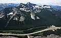
Needle Peak, northeast aspect
|
|
| Highest point | |
| Elevation | 2,095 m (6,873 ft) |
| Prominence | 865 m (2,838 ft) |
| Parent peak | Coquihalla Mountain (2157 m) |
| Geography | |

Needle Peak
Location in British Columbia

Needle Peak
Location in Canada
|
|
| Location | British Columbia, Canada |
| Parent range | North Cascades |
| Topo map | NTS 92H/11 |
| Type of rock | granitic |
| Climbing | |
| Easiest route | Easy scrambling via west ridge |
Needle Peak is a tall mountain in British Columbia, Canada. It stands about 2,095-metre (6,873-foot) high. You can find it in the Coquihalla Summit Recreation Area, which is part of the North Cascades mountain range.
Needle Peak is very close to Coquihalla Summit and not far from Yak Peak. Because it's so close to the Coquihalla Highway, many people love to visit Needle Peak. In summer, they go hiking, and in winter, they enjoy skiing and snowshoeing. Rain and melting snow from the mountain flow into streams that feed the Coquihalla River. Its name, 'Needle Peak,' was officially given in 1936 because it looks like a sharp needle.
How Needle Peak Was Formed
Millions of years ago, during the Ice Age, huge glaciers moved across the land. These glaciers were like giant ice bulldozers. They scraped away rock and dirt, shaping the landscape. This is why many river valleys in the area look like a "U" shape.
Over time, the land also pushed up and cracked. This process, along with the glaciers, created the tall peaks and deep valleys you see in the North Cascades today. The North Cascades has very rugged land with sharp peaks, deep valleys carved by glaciers, and tall granite spires. All these natural events created the different landscapes and climates in the area. This also led to many different types of plants growing there.
Weather at Needle Peak

Needle Peak is in a "marine west coast" climate zone. This means it gets a lot of rain and snow. Most of the weather comes from the Pacific Ocean. When these weather systems hit the Cascade Range, they are forced to rise. As they go higher, they drop their moisture as rain or snow.
Because of this, the Cascade Mountains get a lot of precipitation, especially snow in winter. Temperatures can get very cold, sometimes dropping below -20 degrees Celsius. With the wind, it can feel even colder. The best time to climb Needle Peak is usually from July to September, when the weather is nicer.
Climbing Needle Peak

There are several ways to climb Needle Peak. Some routes are easier, while others are more challenging.
- West Ridge: This route involves trail hiking and some easy scrambling. Scrambling is like climbing over rocks using both your hands and feet.
- South Face: This is another route that involves scrambling.
- Northeast Ridge: This route is a bit more difficult.
- Southeast Buttress: This is the most challenging route, requiring more advanced climbing skills.
Images for kids
-
Needle Peak viewed from Yak Peak, with the Coquihalla Highway below

