Nelsonville, Wisconsin facts for kids
Quick facts for kids
Nelsonville, Wisconsin
|
|
|---|---|
|
Village
|
|

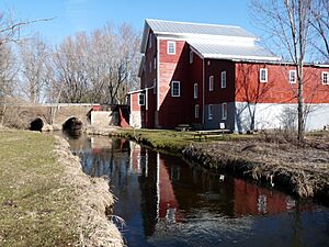
Rising Star Flouring Mill, built in 1868 by Nelsonville's founder
|
|

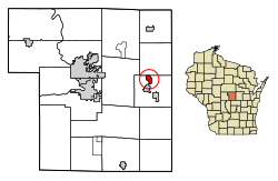
Location of Nelsonville in Portage County, Wisconsin.
|
|
| Country | |
| State | |
| County | Portage |
| Area | |
| • Total | 1.05 sq mi (2.71 km2) |
| • Land | 1.03 sq mi (2.67 km2) |
| • Water | 0.01 sq mi (0.04 km2) |
| Elevation | 1,073 ft (327 m) |
| Population
(2010)
|
|
| • Total | 155 |
| • Estimate
(2019)
|
151 |
| • Density | 146.32/sq mi (56.52/km2) |
| Time zone | UTC-6 (Central (CST)) |
| • Summer (DST) | UTC-5 (CDT) |
| Zip code(s) |
54407, 54458
|
| Area code(s) | 715 & 534 |
| FIPS code | 55-56000 |
| GNIS feature ID | 1570168 |
Nelsonville is a small village located in Portage County, Wisconsin, in the United States. In 2010, about 155 people lived there. It's a quiet place with a rich history.
Contents
History of Nelsonville
The story of Nelsonville began around 1855. An immigrant from England named Jerome Nelson started it all. He built a six-foot-high dam across the Tomorrow River. He also built a sawmill on the riverbank.
After fighting in the Civil War, Jerome Nelson returned. In 1868, he added a flouring mill. This mill helped turn grain into flour. A post office opened in 1871. It was named Nelsonville, after Jerome Nelson.
By 1876, the community was growing. It had a general store called Nelson & Loberg. There was also a shoe shop, Peterson Boots and Shoes. More businesses opened over the years. A Norwegian Lutheran church was built in 1888.
By 1913, about 170 people lived in Nelsonville. Other businesses included Swenson's Furniture Store and the Loberg Company Mill. There was also the Nelsonville Creamery and the State Bank of Nelsonville. The community officially became a village that year. This helped them make their own rules. They wanted to stop saloons and prevent animals from roaming freely on the streets.
Geography of Nelsonville
Nelsonville is located at 44°29′35″N 89°18′44″W / 44.49306°N 89.31222°W. It's a small area.
The village covers about 1.05 square miles (2.71 square kilometers). Most of this area is land. Only a tiny part, about 0.02 square miles (0.04 square kilometers), is water.
People of Nelsonville
| Historical population | |||
|---|---|---|---|
| Census | Pop. | %± | |
| 1920 | 187 | — | |
| 1930 | 198 | 5.9% | |
| 1940 | 180 | −9.1% | |
| 1950 | 188 | 4.4% | |
| 1960 | 170 | −9.6% | |
| 1970 | 152 | −10.6% | |
| 1980 | 199 | 30.9% | |
| 1990 | 171 | −14.1% | |
| 2000 | 191 | 11.7% | |
| 2010 | 155 | −18.8% | |
| 2019 (est.) | 151 | −2.6% | |
| U.S. Decennial Census | |||
Population in 2010
In 2010, Nelsonville had 155 people. These people lived in 61 households. About 39 of these were families. The village had about 150 people per square mile.
Most people in Nelsonville were White (96.8%). A small number were African American or from other backgrounds. About 1.3% of the population was Hispanic or Latino.
Many households (34.4%) had children under 18. Over half (52.5%) were married couples. Some households had a single parent. About 26.2% of households were individuals living alone.
The average age in Nelsonville was 42.5 years. About 25.8% of residents were under 18. Another 14.8% were 65 or older. The population was almost evenly split between males (50.3%) and females (49.7%).
See also
 In Spanish: Nelsonville (Wisconsin) para niños
 | Leon Lynch |
 | Milton P. Webster |
 | Ferdinand Smith |


