
Netherton Tunnel Branch Canal facts for kids
 |
|
| Netherton Tunnel North Portal in use 2007 | |
| Overview | |
|---|---|
| Coordinates | 52°30′16″N 2°03′34″W / 52.50435°N 2.05932°W |
| Status | Open |
| Waterway | Birmingham Canal Navigations |
| Start | 52°30′55″N 2°02′58″W / 52.51534°N 2.04948°W |
| End | 52°29′36″N 2°04′09″W / 52.49335°N 2.06916°W |
| Operation | |
| Owner | Canal and River Trust |
| Technical | |
| Construction | 1855–1858 |
| Length | 9,081 feet (2,768 m) |
| Tunnel clearance | 16 feet (4.9 m) |
| Width | 27 feet (8.2 m) |
| Towpath | Yes (two) |
| Boat-passable | Yes |

The Netherton Tunnel Branch Canal is a historic waterway located in the West Midlands county, England. It is an important part of the Birmingham Canal Navigations (BCN), a large network of canals. This canal was built at a high level, about 453 feet (138 meters) above sea level, known as the Birmingham Level. It is special because it has no locks, which are like water elevators used to raise or lower boats.
The entire branch canal is about 2.4 miles (3.9 km) long. A big part of this length is the Netherton Tunnel itself, which stretches for 9,081 feet (2,768 m). This tunnel was the very last canal tunnel built in Britain during the time when canals were the main way to transport goods.
Contents
Building the Tunnel
The construction of the Netherton Tunnel began on 31 December 1855, when Lord Ward officially started the project. It opened just a few years later, on 20 August 1858. The main goal of this new canal was to connect the towns of Netherton and Tipton in the Black Country.
Why the Tunnel Was Needed
Before the Netherton Tunnel, boats had to use the nearby Dudley Tunnel. This tunnel was very narrow, allowing only one-way traffic at a time. Boats often had to wait for many hours, sometimes even days, to get through. The Netherton Tunnel was built to solve this problem and make boat travel much faster and easier.
Tunnel Design and Features
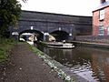
The Netherton Tunnel was designed to be wide enough for two narrowboats to pass each other at the same time. It is 27 feet (8.2 m) wide and is lined with bricks all the way through.
One of its unique features is that it has two towpaths, one on each side. In the past, horses would walk on these paths to pull the boats through the tunnel. You can still see distance markers on the eastern wall today. When it first opened, the tunnel was lit by gas lamps along the towpaths. Later, these were changed to electric lights, but now the tunnel is unlit.
Air Vents: The "Pepper Pots"
Along the top of the tunnel, there are special air vents. These vents help with air circulation and let shafts of light into the tunnel. Locals often call them "pepper pots" because of their shape. They are also lined with bricks, and their openings are covered by iron grates. Because the Netherton Tunnel is wide and has good ventilation, boats can use their engines to travel through it today. This is different from the narrower Dudley Tunnel, where engines are not allowed.
Construction Costs
Building the Netherton Tunnel was quite expensive. It cost £302,000, which was more than the original estimate of £238,000. The main reason for the extra cost was the difficult ground conditions they encountered while digging the tunnel.
Tunnel Repairs
Over the years, the Netherton Tunnel has needed some repairs to keep it in good condition.
In 1983, the British Waterways Board replaced about 80 yards (73.2 m) of the brick floor (called the invert) with concrete. This was because the floor had risen too much, making it hard for boats to pass.
More recently, in 2011, engineers found significant cracks in parts of the tunnel's lining. This meant that traffic through the tunnel had to be limited. Repair work to fix these cracks started in early 2013.
Tunnel Route
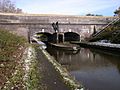
The Netherton Tunnel Branch Canal starts by running south-west from the BCN New Main Line at Dudley Port Junction. It then goes under the Old Main Line at a place called Tividale Aqueduct.
The northern entrance of the tunnel is near Dudley Road West, close to the border between Tipton and Oldbury. Several air-vents are visible along the tunnel's path. One stands in the middle of Aston Road, and another is located between two houses in Regent Road, both in the Tividale Hall area near Dudley.
The southern entrance of the tunnel is in Warrens Hall Park, on the border of Dudley and Rowley Regis. Nearby, you can find the Bumble Hole and Cobb's Engine House. The Bumble Hole is now a beautiful landscaped lake, but it used to be a clay pit. The Dudley No. 2 Canal and the Boshboil Canal Arm meet at Windmill End Junction. The Boshboil Arm was once part of a loop of the original Dudley Canal, but it became a separate arm due to ground sinking.
Important Locations Along the Route
| Point | Coordinates |
|---|---|
| Dudley Port Junction | 52°31′19″N 2°02′36″W / 52.52204°N 2.04331°W |
| Groveland Bridge (Tipton Road, A457) | 52°31′03″N 2°02′51″W / 52.51758°N 2.04760°W |
| Tividale Aqueduct (Old BCN Main Line) | 52°30′59″N 2°02′54″W / 52.51640°N 2.04843°W |
| Northern tunnel portal | 52°30′55″N 2°02′58″W / 52.51534°N 2.04948°W |
| Air vent No. 16 | 52°30′45″N 2°03′07″W / 52.512436°N 2.052015°W |
| Packwood Road Air vent (No. 14) | 52°30′35″N 2°03′16″W / 52.50986°N 2.054329°W |
| Aston Road air vent | 52°30′31″N 2°03′19″W / 52.50850°N 2.05518°W |
| Regent Road air vent | 52°30′25″N 2°03′25″W / 52.50697°N 2.05708°W |
| Approx. tunnel midpoint | 52°30′16″N 2°03′34″W / 52.50435°N 2.05932°W |
| Air vent No. 8 | 52°30′15″N 2°03′34″W / 52.504191°N 2.059364°W |
| Air vent No. 6 | 52°30′06″N 2°03′42″W / 52.501551°N 2.061764°W |
| Air vent No. 4 | 52°29′57″N 2°03′51″W / 52.499036°N 2.064032°W |
| Air vent No. 2 | 52°29′47″N 2°03′59″W / 52.496345°N 2.066459°W |
| Southern tunnel portal | 52°29′36″N 2°04′09″W / 52.49335°N 2.06916°W |
| Windmill End Junction | 52°29′30″N 2°04′13″W / 52.49157°N 2.07019°W |
Gallery
-
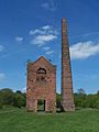
Cobb's Engine House near the southern portal
-
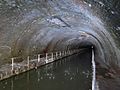
Netherton Tunnel inside northern portal showing the dual towpath
-
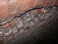
Slippage in the roof of a southern end of the tunnel, caused by the 2002 Dudley earthquake
-
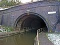
Netherton Tunnel northern portal
-
Tividale Aqueduct with old turbine which once generated electricity to illuminate the tunnel
-
Tividale Aqueduct and Netherton Tunnel northern portal
-
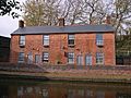
Canal cottages on the branch at Tividale Aqueduct


