New Exchequer Dam facts for kids
Quick facts for kids New Exchequer Dam |
|
|---|---|

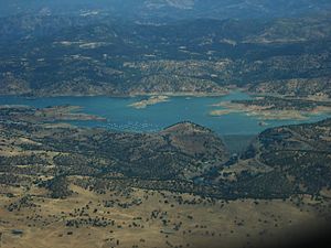
New Exchequer Dam and Lake McClure viewed from the air
|
|
| Country | United States |
| Location | Mariposa County, California |
| Coordinates | 37°35′10″N 120°16′10″W / 37.58611°N 120.26944°W |
| Construction began | 1964 |
| Opening date | 1967 |
| Owner(s) | Merced Irrigation District |
| Dam and spillways | |
| Type of dam | Concrete–faced rockfill |
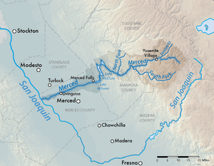
| Impounds | Merced River |
| Height | 490 ft (150 m) |
| Length | 1,220 ft (370 m) |
| Elevation at crest | 879 ft (268 m) |
| Spillways | Gated ogee crest |
| Reservoir | |
| Creates | Lake McClure |
| Total capacity | 1,024,600 acre-feet (1.2638 km3) |
| Catchment area | 1,040.1 sq mi (2,694 km2) |
| Surface area | 7,147 acres (2,892 ha) |
| Maximum length | 29 mi (47 km) |
| Normal elevation | 867 ft (264 m) |
| Power station | |
| Hydraulic head | 437 ft (133 m) |
| Installed capacity | 94.5 MW |
| Annual generation | 279,065,000 KWh (2001–2012) |
The New Exchequer Dam is a huge dam in central California, United States. It's built on the Merced River. This dam creates a big lake called Lake McClure. The lake holds a lot of water – enough to fill over a million football fields!
The dam helps farmers by providing water for their crops. It also makes electricity. The Merced Irrigation District (MID) owns and runs the dam. They also built it.
The New Exchequer Dam was built between 1964 and 1967. It replaced an older dam called the Exchequer Dam. The new dam is 490 feet (150 m) tall. When it was finished, it was the biggest dam of its kind in the world. The dam is named after a town called Exchequer, which is now under the lake. The lake itself is named after Wilbur F. McClure, who was a state engineer in California.
Contents
Building the Dam: A Look Back
The First Exchequer Dam
In 1926, the Merced Irrigation District finished building the first Exchequer Dam. This dam was on the Merced River, about six miles (9.7 kilometres (6.0 mi)) from the town of Merced Falls. It was a concrete dam, 326 feet (99 m) high. It created a lake 14 miles (23 km) long. This lake could hold 281,000 acre-feet (347,000,000 m3) of water.
The main reason for the dam was to provide water for farming. But it also made electricity. On June 23, 1926, President Calvin Coolidge officially started the power plant. It could make 31 megawatts of electricity.
Why a New Dam Was Needed
By the 1950s, the old Exchequer Dam wasn't big enough. Farmers in the Merced River valley needed more water. So, people decided to build a much bigger dam. This new dam would create a lake almost four times larger than the old one.
Construction of the New Dam
Work on the New Exchequer Dam started on July 8, 1964. It was built right downstream from the old dam. A company from San Francisco called Tudor Engineering Company designed the new dam.
The dam was built using layers of rock and dirt. The old Exchequer Dam was even used as a base to help support the new dam. The outside of the new dam was covered with strong reinforced concrete. The main part of the dam was finished in early 1967. The power plant started making electricity by July of that year.
When the new lake filled up, it covered an extra 15 miles (24 km) of the Merced River canyon. It also buried parts of the old Yosemite Valley Railroad and the mining town of Bagby under 50 feet (15 m) of water.
The New Exchequer Dam was one of the first large dams of its type. Because it was a new design, it sometimes leaked a lot of water. The Merced Irrigation District fixed these leaks starting in 1985.
Dam Size and How It's Used
The New Exchequer Dam is 490 feet (150 m) tall from its base. It is 1,220 feet (370 m) long at the top. The dam is 18 feet (5.5 m) wide at the top and 1,000 feet (300 m) wide at the bottom. It's made of a huge amount of rock and dirt – about 5,169,000 cubic yards (3,952,000 m3)!
Controlling Water Flow
When there's a lot of water, like during heavy rains, the dam has a special spillway. This spillway is about 2 miles (3.2 km) north of the dam. It has gates that can open to let extra water out safely.
Making Electricity
The dam also has a power station. This station can make 94.5 megawatts of electricity. It generates about 316 million kilowatt hours of power each year. This is enough electricity for many homes!
Lake McClure's Capacity
Lake McClure can hold a total of 1,024,600 acre-feet (1.2638 km3) of water. About 350,000 acre-feet (0.43 km3) of this is kept empty for flood control. This means there's space to store extra water if there's a big flood.
When the lake is full, the water level is 867 feet (264 m) high. The lake covers 7,147 acres (2,892 ha) of land and has 82 miles (132 km) of shoreline. To prevent floods downstream, the lake only fills into the flood control area if the river flow is expected to be very high.
Dealing with Floods and Droughts
The dam has been very good at stopping major floods. For example, it helped during the New Year's Day Flood of 1997.
However, the dam can't always stop the effects of very bad droughts.
- In 1977, the lake dropped to only 75,000 acre-feet (0.093 km3) of water. This was just one-fourteenth of its full capacity.
- In 1991, the water levels were also very low.
- In February 2015, the lake reached its lowest level ever. It held less than 7 percent of its total capacity because of three years of drought.
Future Plans for the Dam
The Merced Irrigation District has thought about raising the spillway gates. This would allow the dam to hold an extra 70,000 acre⋅ft (0.086 km3) of water. But some people are against this idea. They worry it might flood parts of the Merced River that are protected as "Wild and Scenic". They also say it's not needed because the lake has never overflowed due to flooding since it was built.
Fun at Lake McClure
Lake McClure is also a popular place for fun activities!
- It has 515 campsites for people who want to stay overnight.
- There are four boat ramps for launching boats.
- You can also find two marinas.
In 1992, about 606,000 people visited the lake. Most visitors come between May and September to enjoy the water and outdoors.
 | Dorothy Vaughan |
 | Charles Henry Turner |
 | Hildrus Poindexter |
 | Henry Cecil McBay |


