
Floods in California facts for kids
California experiences many types of floods, but most of them (about 90%) are caused by rivers overflowing. This usually happens because of very heavy rain, lots of snowmelt (when snow turns into water), too much water running over the ground, or when levees (walls built to hold back water) break. Sometimes, it's a mix of all these things.
Here are some of the most important flood events that have happened in California's history.
Contents
Major Floods in California's History
Early Floods (1800s)
Los Angeles Flood of 1825
In 1825, a big flood changed the path of the Los Angeles River. Before this flood, the river flowed west into Santa Monica Bay. After the flood, it started flowing south into San Pedro Bay, which is close to where it flows today.
Sacramento Floods (1850s)
In January 1850, a huge flood hit the new city of Sacramento. Heavy rain made the ground very wet, and both the American River and Sacramento River overflowed at the same time.
More floods happened in Sacramento and other low-lying towns along the Sierra Nevada rivers in the years after 1850. This was partly because of "hydraulic mining" in the foothills. This type of gold mining used powerful jets of water to wash away hillsides. The mud and dirt from this mining supposedly raised the riverbeds in the valley below by about two feet. Hydraulic gold mining became a big issue and was eventually stopped by California lawmakers.
San Diego Storm Surge of 1858
In October 1858, a strong storm caused a huge storm surge in San Diego. The water was so high that it pushed a sailing ship, called a schooner, onto the beach!
The Great Flood of 1861–1862
This was the biggest flood ever recorded in California's history. It started on December 24, 1861, and lasted for 45 days. The entire Sacramento Valley and San Joaquin Valley were covered in water. This area is about 300 miles (480 km) long and 20 miles (32 km) wide!
The state government had to move out of the capital in Sacramento and stay in San Francisco for 18 months. In Orange County, the rain created a huge inland "sea" that lasted about three weeks. The water was about 4 feet (1.2 m) deep and stretched up to 4 miles (6.4 km) from the river.
The Los Angeles area was also flooded, from the San Gabriel Mountains all the way to the Palos Verdes Peninsula. Higher areas became like islands. The Los Angeles area lost 200,000 cattle that drowned. Many homes, ranches, farms, and vineyards were also washed away.
Floods in the Early 1900s
California Flood of 1909
A big storm in 1909 hit areas from Fort Ross on the coast to the Feather River area. One town, La Porte, got an amazing 57.41 inches (1,458 mm) of rain in just 20 days! This kind of rainfall happens only about once every 12,000 years. Because of the floods in 1907 and 1909, California completely changed how it planned its flood control systems.
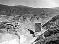
St. Francis Dam Disaster (1928)

On March 12, 1928, a dam that had just been built, called the St. Francis Dam, broke. It was located about 40 miles (64 km) northwest of downtown Los Angeles. The huge rush of water from the broken dam killed at least 431 people, and possibly more.
Crescenta Valley Flood of 1933–1934
In the last week of December 1933, 12 inches (30 cm) of rain fell in the communities of La Crescenta, La Cañada, and Montrose, just north of Los Angeles. On New Year's Eve, even more rain fell. This caused a flood of mud and water around midnight, destroying over 400 homes.
This disaster was even remembered in a song by Woody Guthrie called "Los Angeles New Year's Flood." Because of this flood, the Army Corps of Engineers and Los Angeles County built a special flood control system. This system included catch basins and concrete storm drains to stop such a disaster from happening again.
Santa Ana Flood of 1937
From February 4–7, 1937, a storm brought very heavy rainfall to the Santa Ana River basin. The Riverside North station received over 8 inches (20 cm) of rain in just four days. This was an event that happens only about once every 450 years!
Los Angeles Flood of 1938
Two major storms hit the Los Angeles area between February 27 and March 3, 1938. Over 10 inches (254 mm) of rain fell in just five days. Huge amounts of mud and debris flowed from the San Gabriel Mountains into the Los Angeles Basin.
While Los Angeles County was damaged, Riverside and Orange counties were hit the hardest. A total of 5,601 homes were destroyed, and another 1,500 homes became unsafe to live in. The three main railroads connecting Los Angeles to the rest of the country had bridges washed out and tracks flooded, cutting off the city. The U.S. Coast Guard even had to deliver mail after the flood! This flood killed 115 people and was the worst flood in the region since 1934. As a result, the Flood Control Act of 1941 was passed, which allowed the U.S. Army Corps of Engineers to build many concrete sewers to control floods.
Floods in the Late 1900s
California Flood of 1950
On November 21, 1950, a statewide disaster was declared because of floods. These floods caused 9 deaths and $32 million in damage.
California Flood of 1955
This storm mainly affected the central Sierra mountains and the South Bay area. The Eel River on the North Coast had its highest water flow ever recorded at that time. Rivers in the Central Valley also had near-record flows.
A statewide disaster was declared, with the storm causing 74 deaths and $200 million in economic losses. The most rain in 24 hours was recorded on December 20, when 15.34 inches (390 mm) fell in Shasta County.
Sutter County was hit very hard. On December 24, 1955, a levee on the Feather River broke. A 21-foot (6.4 m) wall of water rushed into the county, flooding 90% of Yuba City and the nearby farmlands. About 600 people were rescued by helicopter, but 37 people drowned.
North Coast California Tsunami of 1964
In March 1964, a huge earthquake in Alaska caused a tsunami to hit the California North Coast. This tsunami completely destroyed several towns. It caused 14 deaths and $14 million in damage in Del Norte County alone.
California Flood of 1964
The six days from December 19–24, 1964, were the wettest ever recorded at many places on the North Coast. Every major stream in the North Coast had new record high water flows. Thirty-four California counties were declared disaster areas.
Northern California Flood of 1982
Heavy rain in the San Francisco Bay area from January 3–5, 1982, caused thousands of mudslides and landslides. It also caused flooding along the San Lorenzo River, Soquel Creek, and Aptos Creek in Santa Cruz County. The landslides caused at least $66 million in damage. Sadly, landslides were responsible for 25 of the 33 deaths caused by the storm. The total cost of the storm was about $280 million.
California and Western Nevada Floods of 1986
From February 11 to February 24, 1986, a strong weather system called a Pineapple Express brought huge amounts of rain to northern California and western Nevada. This nine-day storm brought half of the average yearly rainfall for California!
Record flooding happened in three streams that flow into the southern part of the San Francisco Bay area. There was also a lot of flooding in the Napa and Russian rivers. Napa had its worst flood up to that time. Nearby Calistoga received 29 inches (737 mm) of rain in 10 days, which is a rainfall event that happens only once every thousand years.
The heaviest 24-hour rainfall ever recorded in the Central Valley was 17.60 inches (447 mm) on February 17 in the Feather River area. In Sacramento, almost 10 inches (254 mm) of rain fell in 11 days. Levees broke in the Sacramento River basin, causing terrible floods in the Olivehurst and Linda areas on the Feather River. Linda, about 40 miles (64 km) north of Sacramento, was devastated after the levee on the Yuba River broke, forcing thousands of people to leave their homes.
This California flood resulted in 13 deaths, 50,000 people being evacuated, and over $400 million in property damage.
California Flood of 1995
In January and March 1995, over 100 weather stations recorded their highest one-day rainfall ever. The main part of the January storms hit the Sacramento River Basin, causing small streams to flood, mostly because drainage systems couldn't handle the water. However, almost every part of the state was affected.
The Salinas River rose more than four feet higher than its previous record. The Napa River also set a new record, and the Russian and Pajaro rivers came close to their record peaks. Twenty-eight people were killed, and the flood cost $1.8 billion.
Northern California Flood of 1997
A series of strong storms, fueled by a weather pattern called the Pineapple Express, hit northern California from late December 1996 to early January 1997. December 1996 was one of the wettest Decembers ever recorded.
The Klamath River on California's North Coast experienced major flooding, which permanently changed the river's path in some areas. The Klamath National Forest had its worst flood since 1974. Huge amounts of rain and melted snow rushed into the Feather River and San Joaquin River basins. Rain fell even at very high elevations (up to 11,000 feet or 3,350 m), causing snow to melt quickly.
The Cosumnes River, which flows into the San Joaquin River, was hit the hardest by the flooding. Sacramento was spared, but levee breaks flooded Olivehurst, Arboga, Wilton, Manteca, and Modesto. Huge landslides in the Eldorado National Forest east of Sacramento closed U.S. Route 50. Damages totaled $35 million.
The Sierra Nevada mountains were already soaked when three more storms added over 30 inches (762 mm) of rain in late December 1996 and early January 1997. Levees broke or were topped by water in the Sacramento River Basin, causing a lot of damage. In the San Joaquin River Basin, dozens of levees broke, leading to widespread flooding. The Sacramento-San Joaquin River Delta also had several levee breaks.
Forty-eight counties were declared disaster areas, including all 46 counties in northern California. Over 23,000 homes and businesses, farms, bridges, roads, and flood control systems were damaged, costing about $2 billion. Nine people were killed, and 120,000 people had to leave their homes. About 300 square miles (777 sq km) were flooded, including Yosemite Valley, which flooded for the first time since the Great Flood of 1861–62.
Floods in the 2000s
California Flood of 2017
Significant flooding affected parts of California in January 2017. The Russian River rose three feet (0.9 m) above flood stage, covering about 500 houses with water. Dams were opened to release pressure from the built-up floodwaters. The Sacramento Weir, a structure that helps control river flow, was opened for the first time in eleven years.
Many roads in Northern California were closed due to floods and mudslides, including U.S. Route 395. Over 570,000 customers of the Pacific Gas and Electric Company lost power in Northern and Central California during the event. More than 3,000 people in the Guerneville area had to be evacuated from their homes.
Images for kids
-
The remains of the St. Francis Dam after it broke in March 1928.
